
Sharing Arrangement Between the Department of Industry of Canada and the Federal Communications Commission of the United States of America Concerning the Use of the Frequency Bands 806-824 MHz and 851-869 MHz by the Land Mobile Service Along the Canada-United States Border
Updated March 2022
Contents
- 1. Scope
- 2. Sharing and protection zones
- 3. General sharing arrangements
- 4. Special sharing arrangements
- 5. Technical limits
- 6. Coordination necessitated by the special sharing arangements
- 7. Use of frequencies allotted to one administration by the other administration
- 8. Information exchange
- Annex A
- Annex B
- Annex C
- Annex D
- Annex E
Editor's note:
This document has been updated to correct some errors in the frequency ranges shown in figure 1 of annex B. The frequency bands have been updated to correctly align with the ranges prescribed in sections 3 and 4 of the sharing arrangement. Other editorial corrections have also been made.
The Department of Industry of Canada (Industry Canada), and the Federal Communications Commission of the United States of America (FCC), hereinafter referred to as the “Agencies”,
Have agreed to the following:
1. Scope
1.1 This Arrangement is made pursuant to the Exchange of Notes (October 24, 1962) between the Government of Canada and the Government of the United States of America concerning the coordination and use of radio frequencies above thirty megacycles per second, with annex, completed at Ottawa October 24, 1962, as amended, and covers the sharing and coordination of frequency spectrum for the establishment and operation of land mobile radio services operating in the bands 806 to 824 MHz, and 851 to 869 MHz, along the Canada-United States border.
1.2 Aeronautical and maritime mobile services in this band are not covered by this arrangement but may be subject to special coordination procedures on a case-by-case basis at the request of either Agency prior to their introduction.
1.3 The Agencies may initiate and implement special coordination allowing proposed stations to operate in a manner exceeding the technical conditions stated in this Arrangement within the sharing zones where the affected licensees agree to such conditions. Special coordination may be initiated by either Agency through an exchange of correspondence and must be approved by both Agencies.
1.4 This Arrangement is subject to review at any time at the request of either Agency, the U.S. Department of State or the Department of Foreign Affairs and International Trade Canada.
2. Sharing and Protection Zones
There are three Sharing Zones.
2.1 Sharing Zone I:
This Sharing Zone is the area adjacent to the United States-Canada border East of longitude 121°30′ W and extending a distance of 100 km within either country. However, within Sharing Zone I, the following special geographic areas are recognized:
- (a) In the Great Lakes area there are significant land areas that are within 100 km of the international border between the United States and Canada, but further than 100 km from any land mass of the other country. These areas contain several significant population centers that would benefit from additional spectrum if the lake shores were considered for purposes of sharing. With this in mind, the following cities shall be considered as falling outside of Sharing Zone I, but inside the Protection Zone: in the United States, the cities of Akron, Ohio; Youngstown, Ohio; Syracuse, New York; and in Canada, the cities of Kitchener-Waterloo, Ontario; Peterborough, Ontario; London, Ontario. These cities are defined in Annex A, Table A4 as an area with the given center coordinates and encompassing a circle of 30 km radius.
- (b) Sector 1 and Sector 2 as defined in section 4 below are recognized as special geographic areas within Sharing Zone I.
2.2 Sharing Zone II:
This Sharing Zone is the area adjacent to the United States-Canada border between 121° 30′ and 127° W longitude and extending a distance of 140 km within either country.
2.3 Sharing Zone III:
This Sharing Zone is the area adjacent to the Alaska-British Columbia/Yukon Territory border and extending a distance of 100 km within either country.
2.4 Protection Zone:
The Protection Zones are the areas adjacent to Sharing Zones I and III and extending from 100 to 140 km away from the United States-Canada border within both countries as well as the areas defined in Annex A, Table A4.
3. General Sharing Arrangements
3.1 Paired Channeling Arrangements
Within the Sharing Zones and Protection Zones, the Agencies shall use the spectrum on the basis of a paired frequency channeling plan with mobile station transmitters in the band 806-824 MHz and base station transmitters in the band 851-869 MHz. A mobile station may also transmit on any frequency assigned to its associated base station. Base station to base station transmissions may occur in either of these frequency bands.
3.2 Distribution/Allotment of Frequencies
The frequency bands covered by the Arrangement are to be shared along the border, as indicated below (summarized in Annex B, Figure 1). Each Agency may use their allotted portions of spectrum subject to not causing harmful interference to assignments beyond the allotted frequency band edges and subject to the technical limits described in section 5.
3.2.1 Canada
In the Sharing Zones, except as specified in section 4, Canada has primary use of the frequency bands:
- 809.7500 to 817.2500 MHz,
- 821.0000 to 822.5000 MHz,
- 854.7500 to 862.2500 MHz, and
- 866.0000 to 867.5000 MHz.
Canada also has primary use of the following 25 kHz bandwidth paired channels with the center frequencies as indicated:
- 821.0125 MHz paired with 866.0125 MHz
- 821.5125 MHz paired with 866.5125 MHz
- 822.0125 MHz paired with 867.0125 MHz
- 822.5125 MHz paired with 867.5125 MHz
- 823.0125 MHz paired with 868.0125 MHz.
3.2.2 United States
In the Sharing Zones, except as specified in sections 3.2.1 and 4, the United States has primary use of the frequency bands:
- 806.0000 to 809.7500 MHz,
- 817.2500 to 821.0000 MHz,
- 822.5000 to 824.0000 MHz,
- 851.0000 to 854.7500 MHz,
- 862.2500 to 866.0000 MHz, and
- 867.5000 to 869.0000 MHz.
3.2.3 Shared Channels
The following 25 kHz bandwidth paired channels with the center frequencies as indicated are to be available as public safety interoperability channels.Footnote 1 These channels are available for each Agency’s use in all areas. Usage of these channels in the Sharing Zones may be locally coordinated in accordance with the interoperability requirements of the Canadian and U.S. public safety licensees.
- 806.0125 MHz paired with 851.0125 MHz
- 806.5125 MHz paired with 851.5125 MHz
- 807.0125 MHz paired with 852.0125 MHz
- 807.5125 MHz paired with 852.5125 MHz
- 808.0125 MHz paired with 853.0125 MHz.
Canadian assignments that were operating prior to August 1, 2011 and that comply with the pfd limits as described in Annex E shall be permitted to continue operations under their current parameters on a secondary basis as detailed in section 7.2.
3.2.4 Protection Zones
In the Protection Zones, each Agency has primary use of the frequency bands 806-824 MHz and 851-869 MHz.
3.3 Use of the 806-824 MHz, and 851-869 MHz Bands Outside of the Sharing and Protection Zones
Beyond 140 km from the border, the Agencies have primary use of these bands.
3.4 In the event that harmful interference is experienced, both Agencies shall take appropriate action to eliminate such interference.
4. Special Sharing Arrangements
In recognition of particular demographic circumstances, the Agencies agree on the unequal division of spectrum between Canada and the United States in the following two sectors of Sharing Zone I:
4.1 Sector 1:
Sector 1 is defined to be the portion of Sharing Zone I in the United States and Canada, bounded on the West by 85° W longitude and on the East in Canada by 81° W longitude and in the United States by 80° 30′ W longitude.
In this Sector, except as specified in section 3.2.3, the United States has primary use of the frequency bands:
- 806.0000 to 811.2500 MHz,
- 815.7500 to 821.0000 MHz,
- 821.4500 to 824.0000 MHz,
- 851.0000 to 856.2500 MHz,
- 860.7500 to 866.0000 MHz and
- 866.4500 to 869.0000 MHz.
In this Sector, Canada has primary use of the frequency bands:
- 811.2500 to 815.7500 MHz
- 821.0000 to 821.4500 MHz,
- 856.2500 to 860.7500 MHz and
- 866.0000 to 866.4500 MHz.
4.2 Sector 2:
Sector 2 is defined to be the portion of Sharing Zone I in the United States and Canada, bounded on the East by 71° W longitude and on the West in Canada by 81° W longitude and in the United States by 80° 30′ W longitude.
In this Sector, except as specified in section 3.2.3, the United States has primary use of the frequency bands:
- 806.0000 to 808.2500 MHz,
- 818.7500 to 821.0000 MHz,
- 823.1000 to 824.0000 MHz,
- 851.0000 to 853.2500 MHz,
- 863.7500 to 866.0000 MHz and
- 868.1000 to 869.0000 MHz.
In this Sector, Canada has primary use of the frequency bands:
- 808.2500 to 818.7500 MHz,
- 821.0000 to 823.1000 MHz,
- 853.2500 to 863.7500 MHz and
- 866.0000 to 868.1000 MHz.
Within an area of 30 km radius from the centre city coordinates of London, Ontario, 42° 59′ N. 81° 14′ W., Canada has primary access as defined in section 2.1 (protection zone).
5. Technical Limits
5.1 Within Sharing Zones I (including Sectors 1 and 2) and III, the Agencies may use their allotted portions of spectrum subject to the Effective Radiated Power (ERP) and Effective Antenna Height (EAH) limits of Annex A, Table A1.
5.2 Within Sharing Zone II, the Agencies may use their allotted portions of spectrum subject to the Effective Radiated Power (ERP) and Antenna Height Above Mean Sea Level (AMSL) limits of Annex A, Table A2.
5.3 Each Agency has full use of the 806-824 MHz and 851-869 MHz bands within the Protection Zone in its respective country subject to the condition that base stations not exceed the maximum Effective Radiated Power (ERP) and Effective Antenna Height (EAH) limits of Annex A, Table A1.
5.4 Within the Sharing and Protection Zones, calculation of the limits on Effective Radiated Power (ERP) should be based on the power radiated toward the horizon in the vertical plane and should apply only in the direction of the common border.
5.5 Each Agency may authorize stations that exceed the ERP limits specified in sections 5.1 through 5.4 provided the signal from such a station does not exceed a maximum power flux density (pfd) limit of -107dB (W/m2)/25 kHz at and beyond the border and a maximum ERP of 500 watts in the direction of the common border. If the border falls over water the pfd limit shall apply at the shore beyond the border.
- (a) The Agencies shall require applicants or licensees under this provision to calculate the pfd described in section 5.5 using good engineering practice and generally accepted terrain-sensitive propagation models (with location and time variables of 10% and standard 3 arc-second digitized terrain data). The Agencies shall provide all data and calculations for determining compliance with this Arrangement upon request.
- (b) In the event that the actual pfd at or beyond the border exceeds the value described in section 5.5, it is the responsibility of the licensee to bring the station’s actual pfd into compliance with section 5.5 or bring the station into compliance with the power limits described in sections 5.1 through 5.4.
5.6 Assignments listed in Tables C1 and C2 of Annex C are exempt from the limits on ERP and antenna height detailed in Annex A. These assignments may continue operating at the indicated parameters but are prohibited from modification which would extend their existing 22 dBµV/m interference contour further in the direction of the common border.
6. Coordination Necessitated by the Special Sharing Arrangements
6.1 As a result of the division of spectrum described in sections 4.1 and 4.2, portions of the bands allotted to both countries under this Arrangement overlap. Therefore, the Agencies shall coordinate the proposed frequency assignments in the overlapping portions of those bands, as described in sections 6.2 and 6.3 below, in accordance with the procedures specified in Arrangement A annexed to the Agreement concerning the Coordination and Use of Radio Frequencies Above Thirty Megacycles per Second, as amended 24 June 1965.
6.2 Coordination is required for assignments in the frequency bands 808.2500 to 809.7500 MHz, 817.2500 to 818.7500 MHz, 822.5000 to 823.1000 MHz, 853.2500 to 854.7500 MHz, 862.2500 to 863.7500 MHz and 867.5000 to 868.1000 MHz in the following area (See Annex B, Figure 2):
- (a) The geographical area in Canada enclosed by the United States-Canada border, the meridian 71° W and the line beginning at the intersection of 72° W and the United States-Canada border, thence running North along meridian 72°W to the intersection of 45° 45′ N, thence running East along 45° 45′ N to the meridian 71° W, and
- (b) the geographical area in the United States enclosed by the United States border, the meridian 71° W and the line beginning at the intersection of 44° 25′ N, 71° W, thence running by great circle arc to the intersection of 45°N, 70°W, thence North along meridian 70°W to the intersection of 45° 45′N, thence running West along 45° 45′N to the intersection of the United States-Canada border.
The Agencies shall assign channels in the overlapping bands on center frequencies spaced 25 kHz apart. The FCC shall assign frequencies from 808.2625 to 809.7375 MHz, 817.2625 to 818.7375 MHz, 822.5375 to 823.0875 MHz, 853.2625 to 854.7375 MHz, 862.2625 to 863.7375 MHz and 867.5375 to 868.0875 MHz inclusive. Industry Canada shall assign frequencies from 808.2750 to 809.7250 MHz, 817.2750 to 818.7250 MHz, 822.5500 to 823.0750 MHz, 853.2750 to 854.7250 MHz, 862.2750 to 863.7250 MHz and 867.5500 to 868.0750 MHz inclusive. The Agencies may agree to mutually beneficial changes to the above noted channeling plan in an effort to promote spectral efficiency.
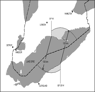
6.3 Coordination is required for assignments in the frequency bands 808.2500 to 811.2500 MHz, 815.7500 to 818.7500 MHz, 821.4500 to 823.1000 MHz, 853.2500 to 856.2500 MHz, 860.7500 to 863.7500 MHz and 866.4500 to 868.1000 MHz in the following area (see Annex B, Figure 3):
- (a) The geographical area in Canada enclosed by the meridian of 81°W longitude, the arc of a circle of 100 km radius centered at 41° 58′N latitude and 80° 30′W longitude at the southern shore of Lake Erie and drawn clockwise from the northerly intersection with 81°W longitude to intersect the United States-Canada border East of 80° 30′W, and the United States-Canada border, and
- (b) the geographical area in the United States enclosed by the meridian of 81°W longitude, the arc of a circle of 100 km radius centered at 42° 39′30″ N latitude and 81°W longitude at the northern shore of Lake Erie and drawn clockwise from the southerly intersection with 80° 30′W longitude to intersect the United States-Canada border West of 81°W, and the United States-Canada border.
The Agencies shall assign channels in the overlapping bands on center frequencies spaced 25 kHz apart. The FCC shall assign frequencies from 808.2625 to 811.2375 MHz, 815.7625 to 818.7375 MHz, 821.4625 to 823.0875 MHz, 853.2625 to 856.2375 MHz, 860.7625 to 863.7375 MHz and 866.4625 to 868.0875 MHz inclusive. Industry Canada shall assign frequencies from 808.2750 to 811.2250 MHz, 815.7750 to 818.7250 MHz, 821.4750 to 823.0750 MHz, 853.2750 to 856.2250 MHz, 860.7750 to 863.7250 MHz and 866.4750 to 868.0750 MHz inclusive. The Agencies may agree to mutually beneficial changes to the above noted channeling plan in an effort to promote spectral efficiency.
Within an area of 30 km radius from the centre city coordinates of London, Ontario, 42° 59′ N. 81° 14′ W., Canada has primary access as defined in section 2.1 (protection zone).
6.4 Canadian assignments listed in Table C3 of Annex C are granted protection against harmful interference from United States stations. These assignments may continue to operate at the indicated parameters but are subject to coordination if modifications are made which would extend their existing 22 dBµV/m interference contour further in the direction of the common border and exceed the technical limits described in section 5.
7. Use of Frequencies Allotted to One Administration by the Other Administration
7.1 Frequencies allotted for primary use of one Agency may be assigned by the other Agency for use within the sharing zones in its country under the following conditions:
- (a) The maximum power flux density (pfd) of the signal at and beyond the border of the primary user’s country does not exceed -124 dB(W/m2)/25 kHz.
- (1) The Agencies shall require applicants or licensees under this provision to calculate the pfd described in section 7.1(a) using good engineering practice and generally accepted terrain-sensitive propagation models (with location and time variables of 10% and standard 3 arc-second digitized terrain data). The Agencies shall provide all data and calculations for determining compliance with this Arrangement upon request.
- (2) In the event that the measured pfd at or beyond the border exceeds the value described in section 7.1(a), it is the responsibility of the licensee to bring the station’s pfd into compliance with section 7.1(a).
- (b) Stations authorized under this provision shall be considered as secondary and shall neither be granted protection against harmful interference from stations that have primary use of their authorized frequency, nor shall they cause harmful interference to stations having primary use of their authorized frequency, regardless of whether they meet the pfd values specified in 7.1(a) above.
- (c) Mobile stations exceeding 5 watts transmitter power output (TPO) shall not be operated in frequencies allotted for primary use of the other Agency within 30 km of the common border.
- (d) Beyond 30 km of the common border, mobile stations operating in frequencies allotted for primary use of the other Agency must not exceed the pfd value specified in 7.1(a).
- (e) The documentation issued by each Agency authorizing such stations to use these frequencies shall include a clause stating that such authorization is subject to the following conditions:
- (1) In the event that the measured signal at or beyond the border is found to exceed -124 dB(W/m2)/25 kHz, the signal level shall be reduced accordingly;
- (2) In the event that harmful interference occurs to any station that has primary use of the authorized frequency, regardless of signal strength, the licensee shall take immediate action to eliminate such interference. The Agency granting the authorization for secondary use is responsible for ensuring that remedial action is taken, up to and including revocation of the authorization.
7.2 Stations that were operating prior to August 1, 2011 and that comply with the pfd limits as described in Annex E shall be permitted to continue operations under their current parameters. Stations authorized under this provision shall neither be granted protection against harmful interference from stations that have primary use of their authorized frequency, nor shall they cause harmful interference to stations having primary use of their authorized frequency.
7.3 Canadian assignments within the coordination zone, listed in Tables C4-1 and C4-2 of Annex C, are operating according to a Special Coordination Procedure (SCP) signed between the Agencies in October 2001. Although this SCP is no longer in effect, the Canadian assignments listed in Tables C4-1 and C4-2 of Annex C may continue to operate in excess of the pfd limit listed in section 7.1(a) above until March 31, 2014 under the following conditions.
- (a) Canadian assignments listed in Table C4-2 of Annex C shall be required to comply with the pfd limit listed in section 7.1(a) within 60 business daysFootnote 2 upon notification by the FCC to Industry Canada that the 22 dBµV/m interference contour of a Canadian assignment overlaps with the 40 dBµV/m protected contour of a co-channel assignment in the United States, which assignment has been made part of the United States’ reconfiguration of the 800 MHz band.
- (b) Canadian assignments listed in Tables C4-1 of Annex C shall be required to comply with the pfd limit listed in section 7.1(a) within 90 business daysFootnote 3 upon notification by the FCC to Industry Canada that the 22 dBµV/m interference contour of a Canadian assignment overlaps with the 40 dBµV/m protected contour of a co-channel assignment in the United States, which assignment has been made as part of the United States’ reconfiguration of the 800 MHz band. The FCC, however, shall exert good faith efforts to avoid assigning a frequency, in connection with 800 MHz band reconfiguration, that requires a Canadian assignment listed in Table C4-1 to comply with the pfd limit listed in section 7.1(a) prior to March 31, 2014.
- (c) In exceptional circumstances in which the FCC may assign a channel unrelated to the 800 MHz band reconfiguration, which assignment creates the co-channel contour overlap described in sections (a) and (b) above, the Agencies shall mutually agree to a time period, reasonable under the circumstances, for the Canadian assignment to comply with the pfd limit listed in section 7.1(a).
- (d) Contour distances referred to in sections (a) and (b) above shall be derived from R-6602 curves, F(50,50) for the protected contour and F(50,10) for the interference contour.
- (e) If a modification is made to a Canadian assignment, that assignment shall be subject to the provisions of section 7.1(a) and shall be removed from Annex C unless the modification causes no extension of the existing 22 dBµV/m interference contour further in the direction of the common border.
- (f) After March 31, 2014, the Canadian assignments listed in Tables C4-1 and C4-2 of Annex C must comply with the pfd limit specified in section 7.1(a). After this date, the United States shall no longer be subject to the restrictions detailed in section (a), (b) or (c) above. The Agencies may agree to a longer period of time for individual Canadian assignments to exceed the pfd limit specified in section 7.1(a) but in this case the individual Canadian assignments shall neither be granted protection against harmful interference from stations that have primary use of their authorized frequency, nor shall they cause harmful interference to stations having primary use of their authorized frequency.
8. Information Exchange
8.1 To facilitate the coordination requirements of this Arrangement, the Agencies shall exchange information including, but not limited to: (1) licensee name(s); (2) licensed service areas; and (3) licensee point(s) of contact; or means to obtain the above information.
8.2 When necessary, the Agencies shall provide information to their respective licensees to facilitate the coordination requirements of this Arrangement.
8.3 To facilitate cross-border coordination between licensees, the Agencies shall encourage licensees to exchange data as listed in Annex D to this Arrangement.
Annex A
Limits of Effective Radiated Power and Antenna Height for General Sharing Arrangements
Effective Radiated Power (ERP) is defined as the product of the power supplied to the antenna and its gain relative to a half-wave dipole in a given direction.
For base stations in Sharing Zones I (include Sectors 1 and 2) and III, and the Protection Zones, Table A1 lists the limits of Effective Radiated Power (ERP) corresponding to the Effective Antenna Height (EAH) ranges shown. In this case, Effective Antenna Height is calculated by subtracting the Assumed Average Terrain Elevation given in Table A3 from the antenna height above mean sea level.
| Effective Antenna Height (EAH) in Meters | ERP Watts (Maximum) |
|---|---|
| Up to 153 | 500 |
| Above 153 to 306 | 125 |
| Above 306 to 458 | 40 |
| Above 458 to 610 | 20 |
| Above 610 to 915 | 10 |
| Above 915 to 1067 | 6 |
| Above 1067 | 5 |
For base stations in Sharing Zone II, Table A2 lists the limits of Effective Radiated Power (ERP) corresponding to the antenna height above mean sea level (AMSL) ranges shown.
| Antenna Height Above Mean Sea Level (AMSL) in Meters | ERP Watts (Maximum) |
|---|---|
| Up to 504 | 500 |
| Above 504 to 610 | 350 |
| Above 610 to 763 | 200 |
| Above 763 to 915 | 140 |
| Above 915 to 1067 | 100 |
| Above 1067 to 1220 | 75 |
| Above 1220 to 1372 | 70 |
| Above 1372 to 1523 | 65 |
| Above 1523 | 5 |
Table A3 lists the values of Assumed Average Terrain Elevations (AATE) within the Sharing and Protection Zones on both sides of the United States-Canada border.
EAH = Antenna Height Above Mean Sea Level - AATE
| Longitude (φ) (°West) | Latitude (Ω) (°North) | Assumed Average Terrain Elevation | |||
|---|---|---|---|---|---|
| United States | Canada | ||||
| Feet | Meters | Feet | Meters | ||
| 65 ≤ Φ < 69 | Ω < 45 | 0 | 0 | 0 | 0 |
| " | 45 ≤ Ω < 46 | 300 | 91 | 300 | 91 |
| " | Ω ≥ 46 | 1000 | 305 | 1000 | 305 |
| 69 ≤ Φ < 73 | All | 2000 | 609 | 1000 | 305 |
| 73 ≤ Φ < 74 | " | 500 | 152 | 500 | 152 |
| 74 ≤ Φ < 78 | " | 250 | 76 | 250 | 76 |
| 78 ≤ Φ < 80 | Ω < 43 | 250 | 76 | 250 | 76 |
| " | Ω ≥ 43 | 500 | 152 | 500 | 152 |
| 80 ≤ Φ < 90 | All | 600 | 183 | 600 | 183 |
| 90 ≤ Φ < 98 | " | 1000 | 305 | 1000 | 305 |
| 98 ≤ Φ < 102 | " | 1500 | 457 | 1500 | 457 |
| 102 ≤ Φ < 108 | " | 2500 | 762 | 2500 | 762 |
| 108 ≤ Φ < 111 | " | 3500 | 1066 | 3500 | 1066 |
| 111 ≤ Φ < 113 | " | 4000 | 1219 | 3500 | 1066 |
| 113 ≤ Φ < 114 | " | 5000 | 1524 | 4000 | 1219 |
| 114 ≤ Φ < 121.5 | " | 3000 | 914 | 3000 | 914 |
| 121.5 ≤ Φ < 127 | " | 0 | 0 | 0 | 0 |
| Φ ≥ 127 | 54 ≤ Ω < 56 | 0 | 0 | 0 | 0 |
| " | 56 ≤ Ω < 58 | 500 | 152 | 1500 | 457 |
| " | 58 ≤ Ω < 60 | 0 | 0 | 2000 | 609 |
| " | 60 ≤ Ω < 62 | 4000 | 1219 | 2500 | 762 |
| " | 62 ≤ Ω < 64 | 1600 | 488 | 1600 | 488 |
| " | 64 ≤ Ω < 66 | 1000 | 305 | 2000 | 609 |
| " | 66 ≤ Ω < 68 | 750 | 228 | 750 | 228 |
| " | 68 ≤ Ω < 69.5 | 1500 | 457 | 500 | 152 |
| " | Ω ≥ 69.5 | 0 | 0 | 0 | 0 |
Table A4 lists cities in the United States and Canada that for the purposes of this agreement shall be considered as falling outside of Sharing Zone I but within the Protection Zone. These cities are defined as circles with a 30 km radius around the center coordinates listed.
| Location | Coordinates (NAD83) | |
|---|---|---|
| Latitude | Longitude | |
| Akron, Ohio | 41° 05′ 00.2" N | 81° 30′ 39.4" W |
| Youngstown, Ohio | 41° 05′ 57.2" N | 80° 39′ 01.3" W |
| Syracuse, New York | 43° 03′ 04.2" N | 76° 09′ 12.7" W |
| Kitchener-Waterloo, Ontario | 43° 27′ 30.2" N | 80° 29′ 59.4" W |
| Peterborough, Ontario | 44° 18′ 00.2" N | 78° 18′ 59.2" W |
| London, Ontario | 42° 59′ 00.0" N | 81° 14′ 00.0" W |
Annex B
| 143° | 127° | 121°30' | 85° | 81° | 71° | 66° | |
| Canada | Protection Zone 806.00-824.00 851.00-869.00 | Sharing Zone II 809.75-817.25 821.00-822.50 854.75-862.25 866.00-867.50 | Protection Zone 806.00-824.00 851.00-869.00 | 40 km | |||
|---|---|---|---|---|---|---|---|
| Sharing Zone III 809.75-817.25 821.00-822.50 854.75-862.25 866.00-867.50 | Sharing Zone I | 100 km | |||||
809.75-817.25 821.00-822.50 854.75-862.25 866.00-867.50 | Sector 1 811.25-815.75 821.00-821.45 856.25-860.75 866.00-866.45 | Sector 2 808.25-818.75 821.00-823.10 853.25-863.75 866.00-868.10 | 809.75-817.25 821.00-822.50 854.75-862.25 866.00-867.50 | ||||
| United States | 806.00-809.75 817.25-821.00 822.50-824.00 851.00-854.75 862.25-866.00 867.50-869.00 Sharing Zone III | 806.00-809.75 817.25-821.00 822.50-824.00 851.00-854.75 862.25-866.00 867.50-869.00 Sharing Zone II | 806.00-809.75 817.25-821.00 822.50-824.00 851.00-854.75 862.25-866.00 867.50-869.00 | 806.00-811.25 815.75-821.00 821.45-824.00 851.00-856.25 860.75-866.00 866.45-869.00 Sector 1 | 806.00-808.25 818.75-821.00 823.10-824.00 851.00-853.25 863.75-866.00 868.10-869.00 Sector 2 | 806.00-809.75 817.25-821.00 822.50-824.00 851.00-854.75 862.25-866.00 867.50-869.00 | 100 km |
806.00-824.00 851.00-869.00 Protection Zone | Sharing Zone I | ||||||
806.00-824.00 851.00-869.00 Protection Zone | 40 km | ||||||
| 143° | 127° | 121°30' | 85° | 80°30' | 71° | 66° | |
Notes:
- - All frequencies are in Megahertz
- - The Protection Zone and Sharing Zones I and III are subject to Annex A, Table A1 requirements
- - Sharing Zone II is subject to Annex A, Table A2 requirements
- - In the Sharing Zones, Canada has primary use of the following 25 kHz bandwidth paired channels with center frequencies as indicated:
- 821.0125 MHz paired with 866.0125 MHz
- 821.5125 MHz paired with 866.5125 MHz
- 822.0125 MHz paired with 867.0125 MHz
- 822.5125 MHz paired with 867.5125 MHz
- 823.0125 MHz paired with 868.0125 MHz
- - The following 25 kHz bandwidth paired channels with the center frequencies as indicated are to be available as public safety interoperability channels.Footnote 4 These channels are available for each Agency’s use in all areas. Usage of these channels in the Sharing Zones may be locally coordinated in accordance with the interoperability requirements of the Canadian and U.S. public safety licensees.
- 806.0125 MHz paired with 851.0125 MHz
- 806.5125 MHz paired with 851.5125 MHz
- 807.0125 MHz paired with 852.0125 MHz
- 807.5125 MHz paired with 852.5125 MHz
- 808.0125 MHz paired with 853.0125 MHz
Canadian assignments that were operating prior to August 1, 2011 and that comply with the pfd limits as described in Annex E shall be permitted to continue operations under their current parameters on a secondary basis as detailed in section 7.2.
Figure 2: Band Overlap Area 1 Where Coordination is Required
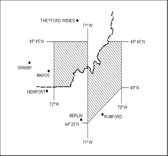
Figure 3: Band Overlap Area 2 Where Coordination is required
| Canada | United States |
|---|---|
| 808.2750-809.7250 | 808.2625-809.7375 |
| 817.2750-818.7250 | 817.2625-818.7375 |
| 821.4750-823.0750 | 821.4625-823.0875 |
| 853.2750-854.7250 | 853.2625-854.7375 |
| 862.2750-863.7250 | 862.2625-863.7375 |
| 866.4750-868.0750 | 866.4625-868.0875 |
| Overlap Bands | |
| 808.2500-809.7500 | |
| 817.2500-818.7500 | |
| 822.5000-823.1000 | |
| 853.2500-854.7500 | |
| 862.2500-863.7500 | |
| 867.5000-868.1000 | |
| Canada | United States |
|---|---|
| 808.2750-811.2250 | 808.2625-811.2375 |
| 815.7750-818.7250 | 815.7625-818.7375 |
| 822.5500-823.0750 | 822.5375-823.0875 |
| 853.2750-856.2250 | 853.2625-856.2375 |
| 860.7750-863.7250 | 860.7625-863.7375 |
| 867.5500-868.0750 | 867.5375-868.0875 |
| Overlap Bands | |
| 808.2500-811.2500 | |
| 815.7500-818.7500 | |
| 821.4500-823.1000 | |
| 853.2500-856.2500 | |
| 860.7500-863.7500 | |
| 866.4500-868.1000 | |
Annex C
Tables C1 and C2 list primary Canadian and U.S. assignments, respectively, that are exempt from the limits on ERP and antenna height detailed in Annex A. These assignments may continue operating at the indicated parameters but are prohibited from modification which would extend their existing 22 dBµV/m interference contour further in the direction of the common border.
| Call Sign | Licence Frequency Record Identifier | Licensee Name | Station location | Administrative District Office | City, Province | Latitude (DDMMSS) | Longitude (DDMMSS) | TX Frequency (MHz) | TX Antenna Height AGL (m) | ERP (dBW) |
|---|---|---|---|---|---|---|---|---|---|---|
| XLM485 | 65034121001 | Department of Fisheries and Oceans | BETHEL NB | 65 | Dartmouth NS | 450954 | 665423 | 861.2875 | 53 | 24.4 |
| CHV355 | 53015181001 | RADIO-ONDE INC. | MONT-SUTTON,QC (SITE RADIO ONDE) | 53 | QUEBEC QC | 450514 | 723304 | 853.7875 | 24 | 18.4 |
| CHV355 | 53015181002 | RADIO-ONDE INC. | MONT-SUTTON,QC (SITE RADIO ONDE) | 53 | QUEBEC QC | 450514 | 723304 | 855.0375 | 24 | 18.4 |
| XKT338 | 46031153001 | Union Gas Limited | THUNDER BAY, ONT. (MT. MCKAY) | 46 | Chatham ON | 482041 | 891711 | 857.9125 | 50 | 25.6 |
| CHV622 | 53009338005 | TECHCOM INC. | MONT O'NEIL (PARC 61A) | 53 | MARIEVILLE QC | 462506 | 704656 | 858.0875 | 61 | 18.6 |
| VES251 | 53012074001 | TECHCOM INC. | MT ST-CECILE | 53 | MARIEVILLE QC | 454137 | 705754 | 859.1375 | 40 | 17.9 |
| VES252 | 53012075002 | TECHCOM INC. | THETFORD MINES | 53 | MARIEVILLE QC | 460852 | 712012 | 858.8625 | 61 | 17.4 |
| VES252 | 53012075001 | TECHCOM INC. | THETFORD MINES | 53 | MARIEVILLE QC | 460852 | 712012 | 859.1125 | 61 | 17.4 |
| XOK829 | 18009508002 | Terasen Gas Inc. | SUMAS MTN - SUMAS PK (CABLE SITE) | 12 | SURREY BC | 490710 | 1220752 | 862.0125 | 44 | 20.6 |
| XOK829 | 18009508001 | Terasen Gas Inc. | SUMAS MTN - SUMAS PK (CABLE SITE) | 12 | SURREY BC | 490710 | 1220752 | 861.4875 | 44 | 20.6 |
| VES294 | 53038284001 | ACTION SOLUTIONS SANS FIL INC. | MONT-ORFORD, QC | 53 | SHERBROOKE QC | 451843 | 721429 | 855.2625 | 15 | 20.7 |
| VES651 | 53034530001 | TECHCOM INC. | MONT-ORFORD,P.Q. | 53 | MARIEVILLE QC | 451843 | 721430 | 862.4125 | 20 | 18 |
| VES651 | 53033804001 | TECHCOM INC. | MONT-ORFORD,P.Q. | 53 | MARIEVILLE QC | 451843 | 721430 | 863.3875 | 20 | 18 |
| VES651 | 53033804002 | TECHCOM INC. | MONT-ORFORD,P.Q. | 53 | MARIEVILLE QC | 451843 | 721430 | 863.1375 | 20 | 18 |
| VES651 | 53014194003 | TECHCOM INC. | MONT-ORFORD,P.Q. | 53 | MARIEVILLE QC | 451843 | 721430 | 862.8625 | 20 | 18 |
| VES238 | 53014338003 | ACTION SOLUTIONS SANS FIL INC. | MONT-ORFORD,QC | 53 | SHERBROOKE QC | 451843 | 721429 | 855.0125 | 15 | 17.1 |
| VES238 | 53014338005 | ACTION SOLUTIONS SANS FIL INC. | MONT-ORFORD,QC | 53 | SHERBROOKE QC | 451843 | 721429 | 855.5125 | 15 | 17.1 |
| VX9EWL | 42075411005 | SINCLAIR TECHNOLOGIES INC. | AURORA, ONT. 85 MARY ST | 42 | AURORA ON | 435957 | 792707 | 853.75 | 10 | 32 |
| VX9EWL | 42075411006 | SINCLAIR TECHNOLOGIES INC. | AURORA, ONT. 85 MARY ST | 42 | AURORA ON | 435957 | 792707 | 854.4 | 10 | 32 |
| VX9EWL | 42075411007 | SINCLAIR TECHNOLOGIES INC. | AURORA, ONT. 85 MARY ST | 42 | AURORA ON | 435957 | 792707 | 855.05 | 10 | 32 |
| VX9EWL | 42075411008 | SINCLAIR TECHNOLOGIES INC. | AURORA, ONT. 85 MARY ST | 42 | AURORA ON | 435957 | 792707 | 855.7 | 10 | 32 |
| VX9EWL | 42075411009 | SINCLAIR TECHNOLOGIES INC. | AURORA, ONT. 85 MARY ST | 42 | AURORA ON | 435957 | 792707 | 856.35 | 10 | 32 |
| VX9EWL | 42075411010 | SINCLAIR TECHNOLOGIES INC. | AURORA, ONT. 85 MARY ST | 42 | AURORA ON | 435957 | 792707 | 857 | 10 | 32 |
| VX9EWL | 42075411011 | SINCLAIR TECHNOLOGIES INC. | AURORA, ONT. 85 MARY ST | 42 | AURORA ON | 435957 | 792707 | 857.675 | 10 | 32 |
| VX9EWL | 42075411012 | SINCLAIR TECHNOLOGIES INC. | AURORA, ONT. 85 MARY ST | 42 | AURORA ON | 435957 | 792707 | 858.35 | 10 | 32 |
| VX9EWL | 42075411013 | SINCLAIR TECHNOLOGIES INC. | AURORA, ONT. 85 MARY ST | 42 | AURORA ON | 435957 | 792707 | 859 | 10 | 32 |
| VX9EWL | 42075411014 | SINCLAIR TECHNOLOGIES INC. | AURORA, ONT. 85 MARY ST | 42 | AURORA ON | 435957 | 792707 | 859.7 | 10 | 32 |
| VX9EWL | 42075411015 | SINCLAIR TECHNOLOGIES INC. | AURORA, ONT. 85 MARY ST | 42 | AURORA ON | 435957 | 792707 | 860.35 | 10 | 32 |
| VX9EWL | 42075411016 | SINCLAIR TECHNOLOGIES INC. | AURORA, ONT. 85 MARY ST | 42 | AURORA ON | 435957 | 792707 | 861.025 | 10 | 32 |
| VX9EWL | 42075411017 | SINCLAIR TECHNOLOGIES INC. | AURORA, ONT. 85 MARY ST | 42 | AURORA ON | 435957 | 792707 | 861.8 | 10 | 32 |
| VAY355 | 45018340001 | Union Gas Limited, C/O: Spectra | MOOREFIELD | 44 | Chatham ON | 434407 | 804606 | 857.6625 | 92 | 21 |
| VBG926 | 18012408003 | METRO MOBILE RADIO SALES INC | MT SEYMOUR BC - METRO MOBILE SITE | 12 | SURREY BC | 492149 | 1225655 | 855.3625 | 20 | 20.6 |
| VBG926 | 12056462001 | METRO MOBILE RADIO SALES INC | MT SEYMOUR BC - METRO MOBILE SITE | 12 | SURREY BC | 492149 | 1225655 | 855.6125 | 20 | 20.6 |
| VBG926 | 12056462002 | METRO MOBILE RADIO SALES INC | MT SEYMOUR BC - METRO MOBILE SITE | 12 | SURREY BC | 492149 | 1225655 | 855.8625 | 20 | 20.6 |
| VBG926 | 12066216001 | METRO MOBILE RADIO SALES INC | MT SEYMOUR BC - METRO MOBILE SITE | 12 | SURREY BC | 492149 | 1225655 | 859.7375 | 20 | 21.3 |
| VBG926 | 18012408002 | METRO MOBILE RADIO SALES INC | MT SEYMOUR BC - METRO MOBILE SITE | 12 | SURREY BC | 492149 | 1225655 | 855.1125 | 20 | 20.6 |
| VBG926 | 18012408001 | METRO MOBILE RADIO SALES INC | MT SEYMOUR BC - METRO MOBILE SITE | 12 | SURREY BC | 492149 | 1225655 | 854.8625 | 20 | 20.6 |
| VAY444 | 45018521001 | Union Gas Limited, C/O: Spectra | ST AGATHA | 44 | Chatham ON | 432700 | 803607 | 857.6625 | 108 | 19.3 |
| CKO88 | 45018341001 | Union Gas Limited, C/O: Spectra | MOUNT FOREST | 44 | Chatham ON | 435932 | 803738 | 857.6625 | 62 | 20.1 |
| CKO81 | 45018389001 | Union Gas Limited, C/O: Spectra | MEAFORD | 44 | Chatham ON | 443056 | 803359 | 857.6625 | 62 | 21 |
| XMO976 | 53017856003 | TELUS COMMUNICATIONS INC. | MT ST-JOSEPH, MEGANTIC, QC | 53 | SCARBOROUGH ON | 452652 | 710712 | 859.0375 | 40 | 18.7 |
| XMO976 | 53017856001 | TELUS COMMUNICATIONS INC. | MT ST-JOSEPH, MEGANTIC, QC | 53 | SCARBOROUGH ON | 452652 | 710712 | 858.5375 | 40 | 18.7 |
| XMO976 | 53017856002 | TELUS COMMUNICATIONS INC. | MT ST-JOSEPH, MEGANTIC, QC | 53 | SCARBOROUGH ON | 452652 | 710712 | 858.7875 | 40 | 18.7 |
| VAG756 | 49026043003 | RCOMM RADIO INC. | VANKLEEK HILL, ON (C&W SITE) | 49 | VANKLEEK HILL ON | 453030 | 743948 | 860.7125 | 61 | 20.9 |
| VAG756 | 49026043001 | RCOMM RADIO INC. | VANKLEEK HILL, ON (C&W SITE) | 49 | VANKLEEK HILL ON | 453030 | 743948 | 860.2125 | 61 | 20.9 |
| VAG756 | 49026043002 | RCOMM RADIO INC. | VANKLEEK HILL, ON (C&W SITE) | 49 | VANKLEEK HILL ON | 453030 | 743948 | 860.4625 | 61 | 20.9 |
| CFJ509 | 33032921001 | SASKTEL MOBILITY- FLEETNET 800 | WOOD MOUNTAIN SASKATCHEWAN | 33 | REGINA, SK | 491733 | 1062656 | 858.1125 | 107 | 21 |
| CFJ509 | 33032921005 | SASKTEL MOBILITY- FLEETNET 800 | WOOD MOUNTAIN SASKATCHEWAN | 33 | REGINA, SK | 491733 | 1062656 | 809.8625 | 107 | 21 |
| CFJ509 | 33032921002 | SASKTEL MOBILITY- FLEETNET 800 | WOOD MOUNTAIN SASKATCHEWAN | 33 | REGINA, SK | 491733 | 1062656 | 861.8375 | 107 | 21 |
| CFJ509 | 33032921003 | SASKTEL MOBILITY- FLEETNET 800 | WOOD MOUNTAIN SASKATCHEWAN | 33 | REGINA, SK | 491733 | 1062656 | 862.0875 | 107 | 21 |
| CFJ509 | 33032921006 | SASKTEL MOBILITY- FLEETNET 800 | WOOD MOUNTAIN SASKATCHEWAN | 33 | REGINA, SK | 491733 | 1062656 | 813.7125 | 107 | 21 |
| CFJ509 | 33032921008 | SASKTEL MOBILITY- FLEETNET 800 | WOOD MOUNTAIN SASKATCHEWAN | 33 | REGINA, SK | 491733 | 1062656 | 814.2125 | 107 | 21 |
| CFJ509 | 33032921007 | SASKTEL MOBILITY- FLEETNET 800 | WOOD MOUNTAIN SASKATCHEWAN | 33 | REGINA, SK | 491733 | 1062656 | 813.9625 | 107 | 21 |
| VBZ971 | 53018826003 | TELUS COMMUNICATIONS INC. | PQ0083 ORFORD, QC | 53 | SAINT-LAURENT QC | 451843 | 721432 | 859.4625 | 22 | 15.4 |
| VBZ971 | 53040775007 | TELUS COMMUNICATIONS INC. | PQ0083 ORFORD, QC | 53 | SAINT-LAURENT QC | 451843 | 721432 | 858.7375 | 22 | 15.4 |
| VBZ971 | 53040775006 | TELUS COMMUNICATIONS INC. | PQ0083 ORFORD, QC | 53 | SAINT-LAURENT QC | 451843 | 721432 | 856.7375 | 22 | 15.4 |
| VBZ971 | 53040775005 | TELUS COMMUNICATIONS INC. | PQ0083 ORFORD, QC | 53 | SAINT-LAURENT QC | 451843 | 721432 | 856.4625 | 22 | 15.4 |
| VBZ971 | 53040775004 | TELUS COMMUNICATIONS INC. | PQ0083 ORFORD, QC | 53 | SAINT-LAURENT QC | 451843 | 721432 | 862.8125 | 22 | 15.4 |
| VBZ971 | 53040775003 | TELUS COMMUNICATIONS INC. | PQ0083 ORFORD, QC | 53 | SAINT-LAURENT QC | 451843 | 721432 | 860.7625 | 22 | 15.4 |
| VBZ971 | 53040775002 | TELUS COMMUNICATIONS INC. | PQ0083 ORFORD, QC | 53 | SAINT-LAURENT QC | 451843 | 721432 | 855.7375 | 22 | 15.4 |
| VBZ971 | 53040775001 | TELUS COMMUNICATIONS INC. | PQ0083 ORFORD, QC | 53 | SAINT-LAURENT QC | 451843 | 721432 | 855.6625 | 22 | 15.4 |
| CFT538 | 55035587003 | TELUS COMMUNICATIONS INC. | PQ0126 MONT STE-ANNE | 53 | SAINT-LAURENT QC | 470508 | 705554 | 861.6875 | 34 | 19.9 |
| CFT538 | 55036295001 | TELUS COMMUNICATIONS INC. | PQ0126 MONT STE-ANNE | 53 | SAINT-LAURENT QC | 470508 | 705554 | 856.0625 | 34 | 19.7 |
| CFT538 | 55036575001 | TELUS COMMUNICATIONS INC. | PQ0126 MONT STE-ANNE | 53 | SAINT-LAURENT QC | 470508 | 705554 | 861.8125 | 34 | 19.9 |
| CFT538 | 53028933001 | TELUS COMMUNICATIONS INC. | PQ0126 MONT STE-ANNE | 53 | SAINT-LAURENT QC | 470508 | 705554 | 861.3125 | 54 | 17.9 |
| CFG592 | 15045275003 | OMEGA COMMUNICATIONS LTD | BLUE GROUSE MOUNTAIN BC | 15 | KELOWNA BC | 495802 | 1193147 | 813.5875 | 11 | 20.2 |
| CFG592 | 15045275006 | OMEGA COMMUNICATIONS LTD | BLUE GROUSE MOUNTAIN BC | 15 | KELOWNA BC | 495802 | 1193147 | 813.6625 | 15 | 20 |
| CFG592 | 15045275001 | OMEGA COMMUNICATIONS LTD | BLUE GROUSE MOUNTAIN BC | 15 | KELOWNA BC | 495802 | 1193147 | 813.0875 | 11 | 20.2 |
| CFG592 | 15045275002 | OMEGA COMMUNICATIONS LTD | BLUE GROUSE MOUNTAIN BC | 15 | KELOWNA BC | 495802 | 1193147 | 813.3375 | 11 | 20.2 |
| CFG592 | 15045275004 | OMEGA COMMUNICATIONS LTD | BLUE GROUSE MOUNTAIN BC | 15 | KELOWNA BC | 495802 | 1193147 | 813.1625 | 15 | 20 |
| CFG592 | 15045275005 | OMEGA COMMUNICATIONS LTD | BLUE GROUSE MOUNTAIN BC | 15 | KELOWNA BC | 495802 | 1193147 | 813.4125 | 15 | 20 |
| VET234 | 53024330005 | TECHCOM INC. | MONT OWLS'HEAD (SITE) | 53 | MARIEVILLE QC | 450346 | 721751 | 860.0375 | 18 | 22.1 |
| VEQ382 | 53028878004 | TELUS COMMUNICATIONS INC. | PQ0277 MONT-TREMBLANT- 663 RUE DE L | 53 | SAINT-LAURENT QC | 460623 | 743512 | 858.6125 | 60 | 17.3 |
| VEQ382 | 53028878003 | TELUS COMMUNICATIONS INC. | PQ0277 MONT-TREMBLANT- 663 RUE DE L | 53 | SAINT-LAURENT QC | 460623 | 743512 | 858.1125 | 60 | 17.3 |
| VEQ382 | 53028878002 | TELUS COMMUNICATIONS INC. | PQ0277 MONT-TREMBLANT- 663 RUE DE L | 53 | SAINT-LAURENT QC | 460623 | 743512 | 855.1125 | 60 | 17.3 |
| VEQ382 | 53028878001 | TELUS COMMUNICATIONS INC. | PQ0277 MONT-TREMBLANT- 663 RUE DE L | 53 | SAINT-LAURENT QC | 460623 | 743512 | 864.8375 | 60 | 17.3 |
| VEQ382 | 53041673001 | TELUS COMMUNICATIONS INC. | PQ0277 MONT-TREMBLANT- 663 RUE DE L | 53 | SAINT-LAURENT QC | 460623 | 743512 | 861.1625 | 60 | 17.3 |
| VEO436 | 12067198002 | TELUS Communications Inc. | BLACK TUSK BC | 12 | Scarborough ON | 495904 | 1230327 | 858.8375 | 30 | 20 |
| VEO436 | 12069484001 | TELUS Communications Inc. | BLACK TUSK BC | 12 | Scarborough ON | 495904 | 1230327 | 856.5375 | 41 | 20 |
| VEO436 | 12072931001 | TELUS Communications Inc. | BLACK TUSK BC | 12 | Scarborough ON | 495904 | 1230327 | 856.1125 | 30 | 20 |
| VEF317 | 53032027007 | RADIO-ONDE INC. | MONT TREMBLANT, QC (TOUR DGT) | 53 | QUEBEC QC | 461310 | 743307 | 859.5375 | 51 | 17.9 |
| VEF317 | 53032027006 | RADIO-ONDE INC. | MONT TREMBLANT, QC (TOUR DGT) | 53 | QUEBEC QC | 461310 | 743307 | 858.8375 | 51 | 17.9 |
| VEF317 | 53032027005 | RADIO-ONDE INC. | MONT TREMBLANT, QC (TOUR DGT) | 53 | QUEBEC QC | 461310 | 743307 | 857.8125 | 51 | 17.9 |
| VEF317 | 53032027001 | RADIO-ONDE INC. | MONT TREMBLANT, QC (TOUR DGT) | 53 | QUEBEC QC | 461310 | 743307 | 858.3375 | 51 | 17.9 |
| VEF317 | 53032082001 | RADIO-ONDE INC. | MONT TREMBLANT, QC (TOUR DGT) | 53 | QUEBEC QC | 461310 | 743307 | 860.0125 | 51 | 17.9 |
| VEF317 | 53032027003 | RADIO-ONDE INC. | MONT TREMBLANT, QC (TOUR DGT) | 53 | QUEBEC QC | 461310 | 743307 | 857.2625 | 51 | 17.9 |
| VEF317 | 53032027002 | RADIO-ONDE INC. | MONT TREMBLANT, QC (TOUR DGT) | 53 | QUEBEC QC | 461310 | 743307 | 859.0875 | 51 | 17.9 |
| VEF317 | 53032082003 | RADIO-ONDE INC. | MONT TREMBLANT, QC (TOUR DGT) | 53 | QUEBEC QC | 461310 | 743307 | 858.0875 | 51 | 17.9 |
| VEF317 | 53032082002 | RADIO-ONDE INC. | MONT TREMBLANT, QC (TOUR DGT) | 53 | QUEBEC QC | 461310 | 743307 | 861.1875 | 51 | 17.9 |
| VEF317 | 53032027004 | RADIO-ONDE INC. | MONT TREMBLANT, QC (TOUR DGT) | 53 | QUEBEC QC | 461310 | 743307 | 857.5625 | 51 | 17.9 |
| CZJ284 | 53041533002 | TELUS COMMUNICATIONS INC. | PQ0118 SAINT-ADELE- LOT P-18, RANG | 53 | SAINT-LAURENT QC | 455705 | 740544 | 853.5375 | 53 | 19.1 |
| CZJ284 | 53041533001 | TELUS COMMUNICATIONS INC. | PQ0118 SAINT-ADELE- LOT P-18, RANG | 53 | SAINT-LAURENT QC | 455705 | 740544 | 865.7625 | 53 | 19.6 |
| CZJ284 | 53032302006 | TELUS COMMUNICATIONS INC. | PQ0118 SAINT-ADELE- LOT P-18, RANG | 53 | SAINT-LAURENT QC | 455705 | 740544 | 864.1625 | 53 | 19.6 |
| CZJ284 | 53032302007 | TELUS COMMUNICATIONS INC. | PQ0118 SAINT-ADELE- LOT P-18, RANG | 53 | SAINT-LAURENT QC | 455705 | 740544 | 853.1375 | 53 | 19.6 |
| CZJ284 | 53032302005 | TELUS COMMUNICATIONS INC. | PQ0118 SAINT-ADELE- LOT P-18, RANG | 53 | SAINT-LAURENT QC | 455705 | 740544 | 864.9625 | 53 | 19.6 |
| CZJ284 | 53032302003 | TELUS COMMUNICATIONS INC. | PQ0118 SAINT-ADELE- LOT P-18, RANG | 53 | SAINT-LAURENT QC | 455705 | 740544 | 853.5125 | 53 | 19.1 |
| CZJ284 | 53032302001 | TELUS COMMUNICATIONS INC. | PQ0118 SAINT-ADELE- LOT P-18, RANG | 53 | SAINT-LAURENT QC | 455705 | 740544 | 862.7625 | 53 | 19.1 |
| CZJ284 | 53032302002 | TELUS COMMUNICATIONS INC. | PQ0118 SAINT-ADELE- LOT P-18, RANG | 53 | SAINT-LAURENT QC | 455705 | 740544 | 858.6625 | 53 | 19.1 |
| CZJ275 | 53032301007 | TELUS COMMUNICATIONS INC. | PQ0139 MONT SAUVAGE, QC | 53 | SAINT-LAURENT QC | 455918 | 741003 | 858.4125 | 76 | 20 |
| CZJ275 | 53032301005 | TELUS COMMUNICATIONS INC. | PQ0139 MONT SAUVAGE, QC | 53 | SAINT-LAURENT QC | 455918 | 741003 | 859.1125 | 76 | 20 |
| CZJ275 | 53032301006 | TELUS COMMUNICATIONS INC. | PQ0139 MONT SAUVAGE, QC | 53 | SAINT-LAURENT QC | 455918 | 741003 | 862.7125 | 76 | 20 |
| CFT696 | 53032310001 | TELUS COMMUNICATIONS INC. | PQ0137 MONT-TREMBLANT- MONT-TREMBLA | 53 | SAINT-LAURENT QC | 461311 | 743307 | 863.7125 | 41 | 18.9 |
| CFT696 | 53032310002 | TELUS COMMUNICATIONS INC. | PQ0137 MONT-TREMBLANT- MONT-TREMBLA | 53 | SAINT-LAURENT QC | 461311 | 743307 | 853.3625 | 41 | 18.9 |
| CFT696 | 53032310003 | TELUS COMMUNICATIONS INC. | PQ0137 MONT-TREMBLANT- MONT-TREMBLA | 53 | SAINT-LAURENT QC | 461311 | 743307 | 854.7875 | 41 | 18.9 |
| CFT696 | 53041467003 | TELUS COMMUNICATIONS INC. | PQ0137 MONT-TREMBLANT- MONT-TREMBLA | 53 | SAINT-LAURENT QC | 461311 | 743307 | 861.9625 | 41 | 18.9 |
| CFT696 | 53033783001 | TELUS COMMUNICATIONS INC. | PQ0137 MONT-TREMBLANT- MONT-TREMBLA | 53 | SAINT-LAURENT QC | 461311 | 743307 | 862.9625 | 41 | 18.9 |
| CFT696 | 53041467002 | TELUS COMMUNICATIONS INC. | PQ0137 MONT-TREMBLANT- MONT-TREMBLA | 53 | SAINT-LAURENT QC | 461311 | 743307 | 861.3125 | 41 | 18.9 |
| CFT696 | 53032310004 | TELUS COMMUNICATIONS INC. | PQ0137 MONT-TREMBLANT- MONT-TREMBLA | 53 | SAINT-LAURENT QC | 461311 | 743307 | 860.9125 | 41 | 18.9 |
| CZJ274 | 53033119003 | TELUS COMMUNICATIONS INC. | PQ0717 L'ETAPE, QC | 53 | SAINT-LAURENT QC | 473413 | 711518 | 863.2625 | 90 | 15.8 |
| CZJ274 | 53033119002 | TELUS COMMUNICATIONS INC. | PQ0717 L'ETAPE, QC | 53 | SAINT-LAURENT QC | 473413 | 711518 | 861.4625 | 90 | 15.8 |
| CZJ274 | 53033119001 | TELUS COMMUNICATIONS INC. | PQ0717 L'ETAPE, QC | 53 | SAINT-LAURENT QC | 473413 | 711518 | 856.8125 | 90 | 15.8 |
| VEQ324 | 53033003003 | TELUS COMMUNICATIONS INC. | PQ0515 BARFORD- 453 10 E RANG , (4 | 53 | SAINT-LAURENT QC | 450810 | 714359 | 861.8125 | 92 | 18.1 |
| VEQ324 | 53035941001 | TELUS COMMUNICATIONS INC. | PQ0515 BARFORD- 453 10 E RANG , (4 | 53 | SAINT-LAURENT QC | 450810 | 714359 | 862.7625 | 92 | 18.1 |
| VEQ324 | 53033003002 | TELUS COMMUNICATIONS INC. | PQ0515 BARFORD- 453 10 E RANG , (4 | 53 | SAINT-LAURENT QC | 450810 | 714359 | 859.0625 | 92 | 18.1 |
| VEQ324 | 53033003001 | TELUS COMMUNICATIONS INC. | PQ0515 BARFORD- 453 10 E RANG , (4 | 53 | SAINT-LAURENT QC | 450810 | 714359 | 856.9125 | 92 | 18.1 |
| CIA247 | 23090356002 | TELUS COMMUNICATIONS INC. | BURTON CREEK - NE 03-07-02 W5 AB498 | 23 | CALGARY AB | 500107 | 1140908 | 852.6875 | 97 | 16.3 |
| CIA247 | 23090356001 | TELUS COMMUNICATIONS INC. | BURTON CREEK - NE 03-07-02 W5 AB498 | 23 | CALGARY AB | 500107 | 1140908 | 861.5375 | 97 | 16.3 |
| CIA247 | 23094112001 | TELUS COMMUNICATIONS INC. | BURTON CREEK - NE 03-07-02 W5 AB498 | 23 | CALGARY AB | 500107 | 1140908 | 851.2125 | 97 | 19.3 |
| CIA334 | 23090422004 | TELUS COMMUNICATIONS INC. | CROWSNEST RIDGE, AB. AB0431 | 23 | CALGARY AB | 493812 | 1143926 | 861.2875 | 54 | 19 |
| CIA339 | 23090423001 | TELUS COMMUNICATIONS INC. | BURMIS, AB. NE 03-07-02 W5 AB439 | 23 | CALGARY AB | 493154 | 1141138 | 861.7875 | 107 | 16.1 |
| CII220 | 53033912006 | TELUS COMMUNICATIONS INC. | PQ0719 TEWKESBURY, QC | 53 | SAINT-LAURENT QC | 470739 | 711715 | 856.0625 | 69 | 21 |
| CII220 | 53033912005 | TELUS COMMUNICATIONS INC. | PQ0719 TEWKESBURY, QC | 53 | SAINT-LAURENT QC | 470739 | 711715 | 854.1625 | 69 | 21 |
| CIG357 | 15053318003 | TELUS Communications Inc. | COQUIHALLA LAKES BC-TOLL PLAZA | 12 | Scarborough ON | 493805 | 1210124 | 860.2625 | 19 | 20 |
| CIG357 | 15053318002 | TELUS Communications Inc. | COQUIHALLA LAKES BC-TOLL PLAZA | 12 | Scarborough ON | 493805 | 1210124 | 860.9625 | 19 | 20 |
| CIG359 | 15053319003 | TELUS Communications Inc. | IRON MOUNTAIN BC (MERRITT) | 12 | Scarborough ON | 500300 | 1204544 | 860.2375 | 77 | 20 |
| CIG359 | 15053319002 | TELUS Communications Inc. | IRON MOUNTAIN BC (MERRITT) | 12 | Scarborough ON | 500300 | 1204544 | 860.9375 | 77 | 20 |
| CIG359 | 15053319001 | TELUS Communications Inc. | IRON MOUNTAIN BC (MERRITT) | 12 | Scarborough ON | 500300 | 1204544 | 864.9625 | 77 | 20 |
| CIG369 | 15053328001 | TELUS Communications Inc. | WART MOUNTAIN BC | 12 | Scarborough ON | 495410 | 1202244 | 861.3875 | 50 | 20 |
| CIG369 | 15053328002 | TELUS Communications Inc. | WART MOUNTAIN BC | 12 | Scarborough ON | 495410 | 1202244 | 860.6875 | 50 | 20 |
| CIG371 | 15053330003 | TELUS Communications Inc. | OKANAGAN MOUNTAIN BC (GVR) | 12 | Scarborough ON | 494244 | 1193632 | 860.0625 | 35 | 20 |
| CIG371 | 15053330002 | TELUS Communications Inc. | OKANAGAN MOUNTAIN BC (GVR) | 12 | Scarborough ON | 494244 | 1193632 | 860.7625 | 35 | 20 |
| CIP589 | 53036109006 | TELUS COMMUNICATIONS INC. | PQ1322 SAINT-COME,QC | 53 | SAINT-LAURENT QC | 461449 | 734820 | 864.8125 | 125 | 20.7 |
| CIP589 | 53039486001 | TELUS COMMUNICATIONS INC. | PQ1322 SAINT-COME,QC | 53 | SAINT-LAURENT QC | 461449 | 734820 | 862.0625 | 125 | 20.1 |
| CIP589 | 53043924001 | TELUS COMMUNICATIONS INC. | PQ1322 SAINT-COME,QC | 53 | SAINT-LAURENT QC | 461449 | 734820 | 863.8375 | 125 | 20.1 |
| CIP589 | 53036109004 | TELUS COMMUNICATIONS INC. | PQ1322 SAINT-COME,QC | 53 | SAINT-LAURENT QC | 461449 | 734820 | 851.5625 | 125 | 20.1 |
| CIP589 | 53036109001 | TELUS COMMUNICATIONS INC. | PQ1322 SAINT-COME,QC | 53 | SAINT-LAURENT QC | 461449 | 734820 | 851.2875 | 125 | 20.1 |
| CIP589 | 53036109002 | TELUS COMMUNICATIONS INC. | PQ1322 SAINT-COME,QC | 53 | SAINT-LAURENT QC | 461449 | 734820 | 852.4125 | 125 | 20.7 |
| CIP589 | 53036109003 | TELUS COMMUNICATIONS INC. | PQ1322 SAINT-COME,QC | 53 | SAINT-LAURENT QC | 461449 | 734820 | 852.9625 | 125 | 20.7 |
| CIP589 | 53036109005 | TELUS COMMUNICATIONS INC. | PQ1322 SAINT-COME,QC | 53 | SAINT-LAURENT QC | 461449 | 734820 | 864.1375 | 125 | 20.7 |
| CIY634 | 13039339006 | TELUS Communications Inc. | BIG WHITE BC (1-BC0531-1) | 12 | Scarborough ON | 494338 | 1185622 | 860.2625 | 57 | 20 |
| CIY634 | 15054141002 | TELUS Communications Inc. | BIG WHITE BC (1-BC0531-1) | 12 | Scarborough ON | 494338 | 1185622 | 860.9625 | 50 | 20 |
| VFJ481 | 44031266003 | TELUS Communications Company | ON1973 SHELBURNE- 476260 - 3RD LINE | 44 | Scarborough ON | 440547 | 801329 | 862.6375 | 90 | 20.8 |
| VFJ481 | 44031266002 | TELUS Communications Company | ON1973 SHELBURNE- 476260 - 3RD LINE | 44 | Scarborough ON | 440547 | 801329 | 860.8875 | 90 | 20.8 |
| VFJ481 | 44031266001 | TELUS Communications Company | ON1973 SHELBURNE- 476260 - 3RD LINE | 44 | Scarborough ON | 440547 | 801329 | 860.3875 | 90 | 20.8 |
| VFJ481 | 44032265001 | TELUS Communications Company | ON1973 SHELBURNE- 476260 - 3RD LINE | 44 | Scarborough ON | 440547 | 801329 | 862.1375 | 90 | 20.8 |
| VFK626 | 53038815002 | TELUS COMMUNICATIONS INC. | PQ0749 DARAN (PARC DES LAURENTIDES) | 53 | SAINT-LAURENT QC | 475806 | 711433 | 856.1875 | 130 | 20 |
| VFK626 | 53038815004 | TELUS COMMUNICATIONS INC. | PQ0749 DARAN (PARC DES LAURENTIDES) | 53 | SAINT-LAURENT QC | 475806 | 711433 | 863.9875 | 130 | 20 |
| VFK626 | 53038815003 | TELUS COMMUNICATIONS INC. | PQ0749 DARAN (PARC DES LAURENTIDES) | 53 | SAINT-LAURENT QC | 475806 | 711433 | 856.5125 | 130 | 20 |
| VFK808 | 44031498002 | TELUS Communications Company | ON1976 ARTHUR- 7539 HIGHWAY 6 | 44 | Scarborough ON | 434822 | 803133 | 859.2125 | 90 | 20.8 |
| VFK808 | 44031498001 | TELUS Communications Company | ON1976 ARTHUR- 7539 HIGHWAY 6 | 44 | Scarborough ON | 434822 | 803133 | 858.4125 | 90 | 20.8 |
| VFK793 | 53038861002 | TELUS COMMUNICATIONS INC. | PQ1556 SAINT-DONAT-DE-RIMOUSKI- PAR | 53 | SAINT-LAURENT QC | 482751 | 681234 | 856.8875 | 91 | 20 |
| VFK793 | 53038861001 | TELUS COMMUNICATIONS INC. | PQ1556 SAINT-DONAT-DE-RIMOUSKI- PAR | 53 | SAINT-LAURENT QC | 482751 | 681234 | 853.4125 | 91 | 20 |
| VFK793 | 53038861003 | TELUS COMMUNICATIONS INC. | PQ1556 SAINT-DONAT-DE-RIMOUSKI- PAR | 53 | SAINT-LAURENT QC | 482751 | 681234 | 861.3125 | 91 | 20 |
| VFL642 | 44031627001 | TELUS Communications Company | ON1975 EAST GARAFRAXA- PART LOT 19, | 44 | Scarborough ON | 435249 | 801851 | 853.4625 | 90 | 20.3 |
| VFL642 | 44031627002 | TELUS Communications Company | ON1975 EAST GARAFRAXA- PART LOT 19, | 44 | Scarborough ON | 435249 | 801851 | 855.4125 | 90 | 20.3 |
| VFR237 | 12071886001 | B C TRANSIT LTD | BOWEN ISLAND MT GARDNER(WBN) | 12 | SURREY BC | 492244 | 1232319 | 862.0875 | 20 | 26.2 |
| VFR237 | 12072293001 | B C TRANSIT LTD | BOWEN ISLAND MT GARDNER(WBN) | 12 | SURREY BC | 492244 | 1232319 | 861.9125 | 20 | 26.2 |
| VFQ796 | 53040734002 | TELUS COMMUNICATIONS INC. | PQ0718 PARC DES LAURENTIDES, QC | 53 | SAINT-LAURENT QC | 472032 | 711056 | 864.7375 | 107 | 20 |
| VFQ796 | 53040734003 | TELUS COMMUNICATIONS INC. | PQ0718 PARC DES LAURENTIDES, QC | 53 | SAINT-LAURENT QC | 472032 | 711056 | 865.8625 | 107 | 20 |
| VFQ796 | 53040734001 | TELUS COMMUNICATIONS INC. | PQ0718 PARC DES LAURENTIDES, QC | 53 | SAINT-LAURENT QC | 472032 | 711056 | 851.5625 | 107 | 20 |
| VFQ809 | 53040735002 | TELUS COMMUNICATIONS INC. | PQ0748 PARC DES LAURENTIDES, QC | 53 | SAINT-LAURENT QC | 474612 | 711202 | 852.2375 | 100 | 20 |
| VFQ809 | 53040735001 | TELUS COMMUNICATIONS INC. | PQ0748 PARC DES LAURENTIDES, QC | 53 | SAINT-LAURENT QC | 474612 | 711202 | 851.0875 | 100 | 20 |
| VFQ809 | 53040735003 | TELUS COMMUNICATIONS INC. | PQ0748 PARC DES LAURENTIDES, QC | 53 | SAINT-LAURENT QC | 474612 | 711202 | 863.8375 | 100 | 20 |
| VFZ649 | 16092964001 | Canada Border Services Agency | MOUNT HAYES BC | 16 | Ottawa ON | 541702 | 1301855 | 867.05 | 20 | 19.7 |
| VFZ808 | 53041796006 | TELUS COMMUNICATIONS INC. | PQ0336 CHERTSEY- LOT 9-B, RANG 7, C | 53 | SAINT-LAURENT QC | 460701 | 735627 | 855.6375 | 105 | 26.1 |
| VFZ808 | 53041796005 | TELUS COMMUNICATIONS INC. | PQ0336 CHERTSEY- LOT 9-B, RANG 7, C | 53 | SAINT-LAURENT QC | 460701 | 735627 | 855.3875 | 105 | 26.1 |
| VFZ808 | 53041796004 | TELUS COMMUNICATIONS INC. | PQ0336 CHERTSEY- LOT 9-B, RANG 7, C | 53 | SAINT-LAURENT QC | 460701 | 735627 | 863.6375 | 110 | 19.9 |
| VFZ808 | 53041796003 | TELUS COMMUNICATIONS INC. | PQ0336 CHERTSEY- LOT 9-B, RANG 7, C | 53 | SAINT-LAURENT QC | 460701 | 735627 | 860.1875 | 110 | 19.9 |
| VFZ808 | 53041796002 | TELUS COMMUNICATIONS INC. | PQ0336 CHERTSEY- LOT 9-B, RANG 7, C | 53 | SAINT-LAURENT QC | 460701 | 735627 | 855.5375 | 110 | 19.9 |
| VFZ808 | 53041796001 | TELUS COMMUNICATIONS INC. | PQ0336 CHERTSEY- LOT 9-B, RANG 7, C | 53 | SAINT-LAURENT QC | 460701 | 735627 | 853.9625 | 110 | 19.9 |
| VFZ808 | 53041796007 | TELUS COMMUNICATIONS INC. | PQ0336 CHERTSEY- LOT 9-B, RANG 7, C | 53 | SAINT-LAURENT QC | 460701 | 735627 | 862.0125 | 105 | 26.1 |
| VFZ808 | 53041796008 | TELUS COMMUNICATIONS INC. | PQ0336 CHERTSEY- LOT 9-B, RANG 7, C | 53 | SAINT-LAURENT QC | 460701 | 735627 | 864.4125 | 105 | 27.7 |
| VXI455 | 23096847001 | TELUS COMMUNICATIONS INC. | BLAIREMORE, AB. AB1693 | 23 | CALGARY AB | 493630 | 1142632 | 861.5375 | 24 | 18.9 |
| VXI455 | 23096847002 | TELUS COMMUNICATIONS INC. | BLAIREMORE, AB. AB1693 | 23 | CALGARY AB | 493630 | 1142632 | 856.4375 | 24 | 18.9 |
| VXI455 | 23096847003 | TELUS COMMUNICATIONS INC. | BLAIREMORE, AB. AB1693 | 23 | CALGARY AB | 493630 | 1142632 | 856.8625 | 24 | 18.9 |
| VXI455 | 23096847004 | TELUS COMMUNICATIONS INC. | BLAIREMORE, AB. AB1693 | 23 | CALGARY AB | 493630 | 1142632 | 861.7875 | 24 | 18.9 |
| VXI455 | 23096847006 | TELUS COMMUNICATIONS INC. | BLAIREMORE, AB. AB1693 | 23 | CALGARY AB | 493630 | 1142632 | 858.9375 | 24 | 18.9 |
| VXI455 | 23096847005 | TELUS COMMUNICATIONS INC. | BLAIREMORE, AB. AB1693 | 23 | CALGARY AB | 493630 | 1142632 | 858.6875 | 24 | 18.9 |
| VXK261 | 49038103001 | TELUS Communications Company | ON1351 CALABOGIE- HIGHWAY 408 AT BA | 49 | SAINT-LAURENT QC | 451552 | 764713 | 855.4125 | 49 | 20.1 |
| VXK261 | 49038103004 | TELUS Communications Company | ON1351 CALABOGIE- HIGHWAY 408 AT BA | 49 | SAINT-LAURENT QC | 451552 | 764713 | 859.0375 | 49 | 20.1 |
| VXK261 | 49038103003 | TELUS Communications Company | ON1351 CALABOGIE- HIGHWAY 408 AT BA | 49 | SAINT-LAURENT QC | 451552 | 764713 | 858.7875 | 49 | 20.1 |
| VXK261 | 49038103002 | TELUS Communications Company | ON1351 CALABOGIE- HIGHWAY 408 AT BA | 49 | SAINT-LAURENT QC | 451552 | 764713 | 858.2375 | 49 | 20.1 |
| VXL892 | 53044422018 | MUNICIPALITÉ DE LA PATRIE | MONT-MEGANTIC | 53 | LA PATRIE QC | 452653 | 710715 | 821.1125 | 4 | 18.2 |
| VXL892 | 53044422015 | MUNICIPALITÉ DE LA PATRIE | MONT-MEGANTIC | 53 | LA PATRIE QC | 452653 | 710715 | 821.1625 | 4 | 18.2 |
| VXL892 | 53044422006 | MUNICIPALITÉ DE LA PATRIE | MONT-MEGANTIC | 53 | LA PATRIE QC | 452653 | 710715 | 821.1875 | 4 | 18.2 |
| VXL892 | 53044422001 | MUNICIPALITÉ DE LA PATRIE | MONT-MEGANTIC | 53 | LA PATRIE QC | 452653 | 710715 | 821.2125 | 4 | 18.2 |
| VXL892 | 53044422022 | MUNICIPALITÉ DE LA PATRIE | MONT-MEGANTIC | 53 | LA PATRIE QC | 452653 | 710715 | 821.3625 | 4 | 18.2 |
| VXL892 | 53044422011 | MUNICIPALITÉ DE LA PATRIE | MONT-MEGANTIC | 53 | LA PATRIE QC | 452653 | 710715 | 821.4125 | 4 | 18.2 |
| VXL892 | 53044422010 | MUNICIPALITÉ DE LA PATRIE | MONT-MEGANTIC | 53 | LA PATRIE QC | 452653 | 710715 | 821.4375 | 4 | 18.2 |
| VXL892 | 53044422019 | MUNICIPALITÉ DE LA PATRIE | MONT-MEGANTIC | 53 | LA PATRIE QC | 452653 | 710715 | 821.6125 | 4 | 18.2 |
| VXL892 | 53044422016 | MUNICIPALITÉ DE LA PATRIE | MONT-MEGANTIC | 53 | LA PATRIE QC | 452653 | 710715 | 821.6625 | 4 | 18.2 |
| VXL892 | 53044422007 | MUNICIPALITÉ DE LA PATRIE | MONT-MEGANTIC | 53 | LA PATRIE QC | 452653 | 710715 | 821.6875 | 4 | 18.2 |
| VXL892 | 53044422002 | MUNICIPALITÉ DE LA PATRIE | MONT-MEGANTIC | 53 | LA PATRIE QC | 452653 | 710715 | 821.7125 | 4 | 18.2 |
| VXL892 | 53044422023 | MUNICIPALITÉ DE LA PATRIE | MONT-MEGANTIC | 53 | LA PATRIE QC | 452653 | 710715 | 821.8625 | 4 | 18.2 |
| VXL892 | 53044422012 | MUNICIPALITÉ DE LA PATRIE | MONT-MEGANTIC | 53 | LA PATRIE QC | 452653 | 710715 | 821.9125 | 4 | 18.2 |
| VXL892 | 53044422020 | MUNICIPALITÉ DE LA PATRIE | MONT-MEGANTIC | 53 | LA PATRIE QC | 452653 | 710715 | 822.1125 | 4 | 18.2 |
| VXL892 | 53044422017 | MUNICIPALITÉ DE LA PATRIE | MONT-MEGANTIC | 53 | LA PATRIE QC | 452653 | 710715 | 822.1625 | 4 | 18.2 |
| VXL892 | 53044422008 | MUNICIPALITÉ DE LA PATRIE | MONT-MEGANTIC | 53 | LA PATRIE QC | 452653 | 710715 | 822.1875 | 4 | 18.2 |
| VXL892 | 53044422003 | MUNICIPALITÉ DE LA PATRIE | MONT-MEGANTIC | 53 | LA PATRIE QC | 452653 | 710715 | 822.2125 | 4 | 18.2 |
| VXL892 | 53044422024 | MUNICIPALITÉ DE LA PATRIE | MONT-MEGANTIC | 53 | LA PATRIE QC | 452653 | 710715 | 822.3625 | 4 | 18.2 |
| VXL892 | 53044422013 | MUNICIPALITÉ DE LA PATRIE | MONT-MEGANTIC | 53 | LA PATRIE QC | 452653 | 710715 | 822.4125 | 4 | 18.2 |
| VXL892 | 53044422005 | MUNICIPALITÉ DE LA PATRIE | MONT-MEGANTIC | 53 | LA PATRIE QC | 452653 | 710715 | 822.4625 | 4 | 18.2 |
| VXL892 | 53044422021 | MUNICIPALITÉ DE LA PATRIE | MONT-MEGANTIC | 53 | LA PATRIE QC | 452653 | 710715 | 822.6125 | 4 | 18.2 |
| VXL892 | 53044422009 | MUNICIPALITÉ DE LA PATRIE | MONT-MEGANTIC | 53 | LA PATRIE QC | 452653 | 710715 | 822.6875 | 4 | 18.2 |
| VXL892 | 53044422004 | MUNICIPALITÉ DE LA PATRIE | MONT-MEGANTIC | 53 | LA PATRIE QC | 452653 | 710715 | 822.7125 | 4 | 18.2 |
| VXL892 | 53044422014 | MUNICIPALITÉ DE LA PATRIE | MONT-MEGANTIC | 53 | LA PATRIE QC | 452653 | 710715 | 822.9125 | 4 | 18.2 |
| In addition, the following Canadian primary assignments, identified by the “Licence Frequency Record Identifier”, are included in Table C1. These Canadian assignments are exempt from the limits on ERP and antenna height detailed in Annex A. The assignments are available to the FCC upon request. 12065313001; 12065313002; 12065313003; 12065313004; 12069437001; 42076744001; 42076744002; 42076744003; 42076744004; 42076744005; 42076744006; 42076744007; 42080573001; 42080573002; 42080573003; 42080573004; 42080573005; 42080573006; 42080573007; 42080573008; 42080573009; 42080573010; 42080573011; 42080573012; 42080573013; 42080573014; 42080573015; 42080573016; 42080573017; 42080573018; 42080573019; 42080573020; 42080573021; 42080573022; 42080573023; 42080574001; 42080574002; 42080574003; 42080574004; 42080574005; 42080574006; 42080574007; 42080574008; 42080574009; 42080574010; 42080574011; 42080574012; 42080574013; 42080574014; 42080574015; 42080574016; 42080574017; 42080574018; 42080574019; 42080574020; 42080574021; 42088631001; 42088631002; 42088631003; 52103029001; 52103029002 | ||||||||||
| Call Sign | Licensee Name | Location County Name | Location Number | Location State | Location Type | Latitude Deg-Min-Sec | Longitude Deg-Min-Sec | TX Frequency (MHz) | TX Antenna Height AGL (m) | ERP (watts) |
|---|---|---|---|---|---|---|---|---|---|---|
| KNGY817 | PROFESSIONAL COMMUNICATIONS MESSAGING SERVICE INC | ERIE | 1 | PA | F | 42-2-21 | 80-3-39 | 863.7625 | 133 | 125 |
| KNGY817 | PROFESSIONAL COMMUNICATIONS MESSAGING SERVICE INC | ERIE | 1 | PA | F | 42-2-21 | 80-3-39 | 864.0125 | 133 | 125 |
| KNGY817 | PROFESSIONAL COMMUNICATIONS MESSAGING SERVICE INC | ERIE | 1 | PA | F | 42-2-21 | 80-3-39 | 864.2875 | 133 | 125 |
| KNGY817 | PROFESSIONAL COMMUNICATIONS MESSAGING SERVICE INC | ERIE | 1 | PA | F | 42-2-21 | 80-3-39 | 864.5375 | 133 | 125 |
| KNGY817 | PROFESSIONAL COMMUNICATIONS MESSAGING SERVICE INC | ERIE | 1 | PA | F | 42-2-21 | 80-3-39 | 864.7875 | 133 | 125 |
| KNIY845 | ANN ARBOR, CITY OF | WASHTENAW | 1 | MI | F | 42-17-10.1 | 83-48-36.8 | 854.0875 | 94 | 400 |
| KNIY845 | ANN ARBOR, CITY OF | WASHTENAW | 1 | MI | F | 42-17-10.1 | 83-48-36.8 | 854.1875 | 94 | 400 |
| KNIY845 | ANN ARBOR, CITY OF | WASHTENAW | 1 | MI | F | 42-17-10.1 | 83-48-36.8 | 854.5875 | 94 | 400 |
| KNIY845 | ANN ARBOR, CITY OF | WASHTENAW | 5 | MI | F | 42-17-47.1 | 83-41-53.8 | 854.6375 | 82 | 400 |
| KNIY845 | ANN ARBOR, CITY OF | WASHTENAW | 1 | MI | F | 42-17-10.1 | 83-48-36.8 | 854.6375 | 94 | 400 |
| KNIY845 | ANN ARBOR, CITY OF | WASHTENAW | 1 | MI | F | 42-17-10.1 | 83-48-36.8 | 854.6875 | 94 | 400 |
| KNIY845 | ANN ARBOR, CITY OF | WASHTENAW | 1 | MI | F | 42-17-10.1 | 83-48-36.8 | 854.8125 | 94 | 400 |
| KNIY845 | ANN ARBOR, CITY OF | WASHTENAW | 1 | MI | F | 42-17-10.1 | 83-48-36.8 | 854.8375 | 94 | 400 |
| KNIY845 | ANN ARBOR, CITY OF | WASHTENAW | 1 | MI | F | 42-17-10.1 | 83-48-36.8 | 854.8875 | 94 | 400 |
| KNIY845 | ANN ARBOR, CITY OF | WASHTENAW | 1 | MI | F | 42-17-10.1 | 83-48-36.8 | 855.0875 | 94 | 400 |
| KNIY845 | ANN ARBOR, CITY OF | WASHTENAW | 1 | MI | F | 42-17-10.1 | 83-48-36.8 | 855.1875 | 94 | 400 |
| KNIY845 | ANN ARBOR, CITY OF | WASHTENAW | 1 | MI | F | 42-17-10.1 | 83-48-36.8 | 855.7375 | 94 | 400 |
| KNIY845 | ANN ARBOR, CITY OF | WASHTENAW | 1 | MI | F | 42-17-10.1 | 83-48-36.8 | 855.7625 | 94 | 400 |
| KNIY845 | ANN ARBOR, CITY OF | WASHTENAW | 1 | MI | F | 42-17-10.1 | 83-48-36.8 | 855.8125 | 94 | 400 |
| KNNJ877 | ERIE COUNTY WATER AUTHORITY | ERIE | 1 | NY | F | 42-41-39.2 | 78-43-17.1 | 853.0625 | 34 | 100 |
| KNNK692 | BUSH ELECTRONICS INC | ONONDAGA | 1 | NY | F | 42-57-19 | 76-6-33 | 854.2375 | 64 | 125 |
| KNNL529 | GENESEE COUNTY OF | GENESEE | 1 | MI | F | 43-8-4.1 | 83-35-41.8 | 851.8 | 111 | 239 |
| KNNL529 | GENESEE COUNTY OF | GENESEE | 2 | MI | F | 42-52-11.1 | 83-48-10.8 | 853.2125 | 85 | 236 |
| KNNM677 | WAYNE, COUNTY OF EMERGENCY COMMUNICATIONS DEPARTMENT | WAYNE | 1 | NY | F | 43-8-55.2 | 77-4-7.9 | 864.0375 | 58 | 425 |
| KNRU342 | WASHINGTON COMMUNICATIONS LLC DBA Day Wireless Systems | FERRY | 1 | WA | F | 47-54-38 | 118-26-31 | 854.8625 | 20 | 200 |
| KNRU376 | APT Wireless | SITKA | 1 | AK | F | 57-34-24 | 135-16-57 | 854.2875 | 6 | 85 |
| KNRU376 | APT Wireless | SITKA | 1 | AK | F | 57-34-24 | 135-16-57 | 854.5375 | 6 | 85 |
| KNRU376 | APT Wireless | SITKA | 1 | AK | F | 57-34-24 | 135-16-57 | 854.8625 | 6 | 85 |
| KNRU376 | APT Wireless | SITKA | 1 | AK | F | 57-34-24 | 135-16-57 | 855.1125 | 6 | 85 |
| KNRU376 | APT Wireless | SITKA | 1 | AK | F | 57-34-24 | 135-16-57 | 855.8625 | 6 | 85 |
| KNRU378 | APT Wireless | 1 | AK | F | 55-45-3 | 132-54-11 | 854.2875 | 6 | 85 | |
| KNRU378 | APT Wireless | 1 | AK | F | 55-45-3 | 132-54-11 | 854.5375 | 6 | 85 | |
| KNRU378 | APT Wireless | 1 | AK | F | 55-45-3 | 132-54-11 | 854.8625 | 6 | 85 | |
| KNRU378 | APT Wireless | 1 | AK | F | 55-45-3 | 132-54-11 | 855.1125 | 6 | 85 | |
| KNRU378 | APT Wireless | 1 | AK | F | 55-45-3 | 132-54-11 | 855.8625 | 6 | 85 | |
| KNRU379 | APT Wireless | WRANGELL-PETERSBURG | 1 | AK | F | 56-44-3 | 133-4-11 | 862.3125 | 6 | 85 |
| KNRU379 | APT Wireless | WRANGELL-PETERSBURG | 1 | AK | F | 56-44-3 | 133-4-11 | 862.5625 | 6 | 85 |
| KNRU379 | APT Wireless | WRANGELL-PETERSBURG | 1 | AK | F | 56-44-3 | 133-4-11 | 862.8125 | 6 | 85 |
| KNRU379 | APT Wireless | WRANGELL-PETERSBURG | 1 | AK | F | 56-44-3 | 133-4-11 | 863.0625 | 6 | 85 |
| KNRU379 | APT Wireless | WRANGELL-PETERSBURG | 1 | AK | F | 56-44-3 | 133-4-11 | 863.3125 | 6 | 85 |
| WNED563 | STERLING CONCRETE PRODUCTS INC | OAKLAND | 3 | MI | F | 42-42-46.1 | 83-13-43.8 | 862.0625 | 46 | 224 |
| WNHD787 | CITY OF CANTON | STARK | 2 | OH | F | 40-49-57.2 | 81-23-8.4 | 854.0375 | 56 | 180 |
| WNHD787 | CITY OF CANTON | STARK | 2 | OH | F | 40-49-57.2 | 81-23-8.4 | 854.5375 | 56 | 180 |
| WNHD787 | CITY OF CANTON | STARK | 2 | OH | F | 40-49-57.2 | 81-23-8.4 | 855.0375 | 56 | 180 |
| WNHD787 | CITY OF CANTON | STARK | 2 | OH | F | 40-49-57.2 | 81-23-8.4 | 857.0125 | 56 | 180 |
| WNHD787 | CITY OF CANTON | STARK | 2 | OH | F | 40-49-57.2 | 81-23-8.4 | 857.5125 | 56 | 180 |
| WNHN225 | REGENTS OF THE UNIVERSITY OF MICHIGAN | WASHTENAW | 2 | MI | F | 42-17-47.1 | 83-41-53.8 | 854.0375 | 82 | 134 |
| WNHN225 | REGENTS OF THE UNIVERSITY OF MICHIGAN | WASHTENAW | 2 | MI | F | 42-17-47.1 | 83-41-53.8 | 854.2125 | 82 | 134 |
| WNHN225 | REGENTS OF THE UNIVERSITY OF MICHIGAN | WASHTENAW | 2 | MI | F | 42-17-47.1 | 83-41-53.8 | 854.2625 | 82 | 134 |
| WNHN225 | REGENTS OF THE UNIVERSITY OF MICHIGAN | WASHTENAW | 2 | MI | F | 42-17-47.1 | 83-41-53.8 | 854.7625 | 82 | 134 |
| WNHN225 | REGENTS OF THE UNIVERSITY OF MICHIGAN | WASHTENAW | 2 | MI | F | 42-17-47.1 | 83-41-53.8 | 855.0375 | 82 | 134 |
| WNHN225 | REGENTS OF THE UNIVERSITY OF MICHIGAN | WASHTENAW | 2 | MI | F | 42-17-47.1 | 83-41-53.8 | 855.2625 | 82 | 134 |
| WNHN225 | REGENTS OF THE UNIVERSITY OF MICHIGAN | WASHTENAW | 2 | MI | F | 42-17-47.1 | 83-41-53.8 | 855.5375 | 82 | 134 |
| WNHN225 | REGENTS OF THE UNIVERSITY OF MICHIGAN | WASHTENAW | 2 | MI | F | 42-17-47.1 | 83-41-53.8 | 855.6125 | 82 | 134 |
| WNHN225 | REGENTS OF THE UNIVERSITY OF MICHIGAN | WASHTENAW | 2 | MI | F | 42-17-47.1 | 83-41-53.8 | 855.7125 | 82 | 134 |
| WNHN225 | REGENTS OF THE UNIVERSITY OF MICHIGAN | WASHTENAW | 2 | MI | F | 42-17-47.1 | 83-41-53.8 | 855.9375 | 82 | 134 |
| WNHN225 | REGENTS OF THE UNIVERSITY OF MICHIGAN | WASHTENAW | 2 | MI | F | 42-17-47.1 | 83-41-53.8 | 860.8375 | 82 | 134 |
| WNHZ202 | DETROIT, CITY OF | WAYNE | 5 | MI | F | 42-19-49.1 | 83-2-51.7 | 854.1625 | 168 | 300 |
| WNHZ202 | DETROIT, CITY OF | WAYNE | 5 | MI | F | 42-19-49.1 | 83-2-51.7 | 854.7375 | 168 | 300 |
| WNHZ202 | DETROIT, CITY OF | WAYNE | 5 | MI | F | 42-19-49.1 | 83-2-51.7 | 855.1625 | 168 | 300 |
| WNHZ202 | DETROIT, CITY OF | WAYNE | 5 | MI | F | 42-19-49.1 | 83-2-51.7 | 855.9625 | 168 | 300 |
| WNLH288 | THE BOEING COMPANY | KITSAP | 6 | WA | F | 47-32-51.3 | 122-46-57.5 | 862.2875 | 45 | 430 |
| WNLH288 | THE BOEING COMPANY | KITSAP | 6 | WA | F | 47-32-51.3 | 122-46-57.5 | 862.8625 | 45 | 430 |
| WNLH288 | THE BOEING COMPANY | KITSAP | 6 | WA | F | 47-32-51.3 | 122-46-57.5 | 863.3125 | 45 | 430 |
| WNLU970 | DETROIT, CITY OF | WAYNE | 5 | MI | F | 42-19-49.1 | 83-2-51.7 | 856.1125 | 168 | 300 |
| WNMD400 | APT Wireless | 1 | AK | F | 55-21-37 | 131-47-48 | 862.5625 | 6 | 85 | |
| WNMD400 | APT Wireless | 1 | AK | F | 55-21-37 | 131-47-48 | 862.8125 | 6 | 85 | |
| WNMD400 | APT Wireless | 1 | AK | F | 55-21-37 | 131-47-48 | 863.0625 | 6 | 85 | |
| WNMD400 | APT Wireless | 1 | AK | F | 55-21-37 | 131-47-48 | 863.3125 | 6 | 85 | |
| WNMD400 | APT Wireless | 1 | AK | F | 55-21-37 | 131-47-48 | 863.3625 | 6 | 85 | |
| WNMD400 | APT Wireless | 1 | AK | F | 55-21-37 | 131-47-48 | 863.6125 | 6 | 85 | |
| WNMD400 | APT Wireless | 1 | AK | F | 55-21-37 | 131-47-48 | 863.6625 | 6 | 85 | |
| WNMD429 | GENESSEE, COUNTY OF | GENESEE | 1 | NY | F | 42-59-24.2 | 78-23-31.1 | 853.0375 | 110 | 88 |
| WNPS266 | RAVENNA SCHOOL SYSTEM | PORTAGE | 1 | OH | F | 41-9-38.2 | 81-15-35.4 | 860.5625 | 38 | 500 |
| WNPS355 | WASHINGTON, STATE OF; Dept. of Transportation | CHELAN | 3 | WA | F | 47-47-19.4 | 120-48-29.3 | 851.3375 | 12 | 150 |
| WNPS355 | WASHINGTON, STATE OF; Dept. of Transportation | KING | 2 | WA | F | 47-45-4.4 | 121-5-34.4 | 854.4875 | 15 | 265 |
| WNRN975 | SNOHOMISH, COUNTY OF | SNOHOMISH | 10 | WA | F | 48-18-8 | 121-59-47 | 851.1125 | 48.8 | 200 |
| WNRN975 | SNOHOMISH, COUNTY OF | SNOHOMISH | 10 | WA | F | 48-18-8 | 121-59-47 | 851.7375 | 48.8 | 200 |
| WNRN975 | SNOHOMISH, COUNTY OF | SNOHOMISH | 10 | WA | F | 48-18-8 | 121-59-47 | 852.3125 | 48.8 | 200 |
| WNUD784 | ANN ARBOR TRANSPORTATION AUTHORITY | WASHTENAW | 1 | MI | F | 42-14-45.1 | 83-48-1.8 | 856.1375 | 40 | 142 |
| WNVP201 | WASHINGTON, STATE OF; Dept. of Transportation | WHATCOM | 1 | WA | F | 48-54-34.4 | 122-13-21.6 | 854.3375 | 14 | 200 |
| WNVP201 | WASHINGTON, STATE OF; Dept. of Transportation | WHATCOM | 1 | WA | F | 48-54-34.4 | 122-13-21.6 | 854.4875 | 14 | 200 |
| WNVP201 | WASHINGTON, STATE OF; Dept. of Transportation | WHATCOM | 1 | WA | F | 48-54-34.4 | 122-13-21.6 | 854.5625 | 14 | 200 |
| WNZT395 | WASHINGTON, STATE OF; Dept. of Transportation | JEFFERSON | 2 | WA | F | 47-45-9.3 | 122-55-47.6 | 851.7875 | 6 | 200 |
| WNZT395 | WASHINGTON, STATE OF; Dept. of Transportation | JEFFERSON | 2 | WA | F | 47-45-9.3 | 122-55-47.6 | 854.3375 | 6 | 200 |
| WNZT395 | WASHINGTON, STATE OF; Dept. of Transportation | JEFFERSON | 2 | WA | F | 47-45-9.3 | 122-55-47.6 | 854.4875 | 6 | 200 |
| WNZZ762 | WASHINGTON, STATE OF; Dept. of Transportation | OKANOGAN | 2 | WA | F | 48-32-43.6 | 119-14-12.2 | 854.7375 | 9 | 200 |
| WNZZ763 | WASHINGTON, STATE OF; Dept. of Transportation | STEVENS | 1 | WA | F | 48-26-12.7 | 117-30-8.9 | 851.3375 | 14 | 200 |
| WNZZ763 | WASHINGTON, STATE OF; Dept. of Transportation | STEVENS | 1 | WA | F | 48-26-12.7 | 117-30-8.9 | 854.3875 | 14 | 200 |
| WNZZ763 | WASHINGTON, STATE OF; Dept. of Transportation | STEVENS | 1 | WA | F | 48-26-12.7 | 117-30-8.9 | 854.6125 | 14 | 200 |
| WNZZ763 | WASHINGTON, STATE OF; Dept. of Transportation | STEVENS | 1 | WA | F | 48-26-12.7 | 117-30-8.9 | 854.7375 | 14 | 200 |
| WNZZ770 | WASHINGTON, STATE OF; Dept. of Transportation | OKANOGAN | 1 | WA | F | 48-44-10.5 | 120-41-13.4 | 851.7875 | 8 | 200 |
| WNZZ770 | WASHINGTON, STATE OF; Dept. of Transportation | OKANOGAN | 1 | WA | F | 48-44-10.5 | 120-41-13.4 | 854.3375 | 8 | 200 |
| WNZZ770 | WASHINGTON, STATE OF; Dept. of Transportation | OKANOGAN | 1 | WA | F | 48-44-10.5 | 120-41-13.4 | 854.4875 | 8 | 200 |
| WNZZ770 | WASHINGTON, STATE OF; Dept. of Transportation | OKANOGAN | 1 | WA | F | 48-44-10.5 | 120-41-13.4 | 854.5625 | 8 | 200 |
| WNZZ775 | WASHINGTON, STATE OF; Dept. of Transportation | SPOKANE | 1 | WA | F | 47-55-3.6 | 117-7-21.7 | 851.3875 | 9 | 200 |
| WNZZ775 | WASHINGTON, STATE OF; Dept. of Transportation | SPOKANE | 1 | WA | F | 47-55-3.6 | 117-7-21.7 | 851.7875 | 9 | 200 |
| WNZZ775 | WASHINGTON, STATE OF; Dept. of Transportation | SPOKANE | 1 | WA | F | 47-55-3.6 | 117-7-21.7 | 854.1375 | 9 | 200 |
| WNZZ775 | WASHINGTON, STATE OF; Dept. of Transportation | SPOKANE | 1 | WA | F | 47-55-3.6 | 117-7-21.7 | 854.5375 | 9 | 200 |
| WNZZ807 | WASHINGTON, STATE OF; Dept. of Transportation | OKANOGAN | 1 | WA | F | 48-23-15.5 | 119-55-38.3 | 851.3375 | 11 | 200 |
| WNZZ807 | WASHINGTON, STATE OF; Dept. of Transportation | OKANOGAN | 1 | WA | F | 48-23-15.5 | 119-55-38.3 | 854.3875 | 11 | 200 |
| WNZZ807 | WASHINGTON, STATE OF; Dept. of Transportation | OKANOGAN | 1 | WA | F | 48-23-15.5 | 119-55-38.3 | 854.6125 | 11 | 200 |
| WPAT907 | Johnson Repeater Co., Inc. | CHARLEVOIX | 1 | MI | F | 45-10-12 | 84-45-4 | 860.0125 | 137 | 250 |
| WPAT907 | Johnson Repeater Co., Inc. | CHARLEVOIX | 1 | MI | F | 45-10-12 | 84-45-4 | 860.5125 | 137 | 250 |
| WPBV618 | MICHIGAN, STATE OF | WAYNE | 1 | MI | F | 42-25-22 | 83-27-39 | 851.0125 | 99 | 346.7 |
| WPBV618 | MICHIGAN, STATE OF | WAYNE | 1 | MI | F | 42-25-22 | 83-27-39 | 851.5125 | 99 | 346.7 |
| WPBV618 | MICHIGAN, STATE OF | WAYNE | 1 | MI | F | 42-25-22 | 83-27-39 | 851.8625 | 99 | 346.7 |
| WPBV618 | MICHIGAN, STATE OF | WAYNE | 1 | MI | F | 42-25-22 | 83-27-39 | 851.925 | 99 | 346.7 |
| WPBV618 | MICHIGAN, STATE OF | WAYNE | 1 | MI | F | 42-25-22 | 83-27-39 | 852.8625 | 99 | 346.7 |
| WPBV618 | MICHIGAN, STATE OF | WAYNE | 1 | MI | F | 42-25-22 | 83-27-39 | 852.925 | 99 | 346.7 |
| WPCI209 | WASHINGTON, STATE OF; Dept. of Transportation | CHELAN | 1 | WA | F | 47-45-11.4 | 121-5-31.4 | 851.3375 | 17 | 200 |
| WPCI209 | WASHINGTON, STATE OF; Dept. of Transportation | CHELAN | 1 | WA | F | 47-45-11.4 | 121-5-31.4 | 854.3875 | 17 | 200 |
| WPCI209 | WASHINGTON, STATE OF; Dept. of Transportation | CHELAN | 1 | WA | F | 47-45-11.4 | 121-5-31.4 | 854.6125 | 17 | 200 |
| WPCQ246 | AMERICAN ELECTRIC POWER SERVICE CORPORATION | HOLMES | 3 | OH | F | 40-33-0.2 | 81-51-22.5 | 858.3875 | 141 | 125 |
| WPCQ246 | AMERICAN ELECTRIC POWER SERVICE CORPORATION | HOLMES | 3 | OH | F | 40-33-0.2 | 81-51-22.5 | 859.3875 | 141 | 125 |
| WPCQ246 | AMERICAN ELECTRIC POWER SERVICE CORPORATION | HOLMES | 3 | OH | F | 40-33-0.2 | 81-51-22.5 | 860.3875 | 141 | 125 |
| WPDV809 | STONES MOBILE RADIO INC | NELSON | 2 | ND | F | 47-52-38 | 97-59-36 | 856.6875 | 128 | 147 |
| WPDV809 | STONES MOBILE RADIO INC | NELSON | 2 | ND | F | 47-52-38 | 97-59-36 | 857.6875 | 128 | 147 |
| WPDV809 | STONES MOBILE RADIO INC | NELSON | 2 | ND | F | 47-52-38 | 97-59-36 | 858.6875 | 128 | 147 |
| WPDV809 | STONES MOBILE RADIO INC | NELSON | 2 | ND | F | 47-52-38 | 97-59-36 | 859.6875 | 128 | 147 |
| WPDV809 | STONES MOBILE RADIO INC | NELSON | 2 | ND | F | 47-52-38 | 97-59-36 | 860.6875 | 128 | 147 |
| WPEA419 | Shilot, Rodney W | SPOKANE | 1 | WA | F | 47-56-31 | 117-40-33 | 856.5625 | 24 | 350 |
| WPEA419 | Shilot, Rodney W | SPOKANE | 1 | WA | F | 47-56-31 | 117-40-33 | 857.5625 | 24 | 350 |
| WPEA419 | Shilot, Rodney W | SPOKANE | 1 | WA | F | 47-56-31 | 117-40-33 | 860.5625 | 24 | 350 |
| WPFC820 | WASHINGTON, STATE OF; Dept. of Transportation | KING | 2 | WA | F | 47-29-19.4 | 121-56-48.4 | 851.3375 | 37 | 200 |
| WPFC820 | WASHINGTON, STATE OF; Dept. of Transportation | KING | 2 | WA | F | 47-29-19.4 | 121-56-48.4 | 854.3875 | 37 | 200 |
| WPFC820 | WASHINGTON, STATE OF; Dept. of Transportation | KING | 2 | WA | F | 47-29-19.4 | 121-56-48.4 | 854.6125 | 37 | 200 |
| WPFE506 | WASHINGTON, STATE OF; Dept. of Transportation | CLALLAM | 1 | WA | F | 48-5-4.3 | 124-4-21.7 | 854.3375 | 12 | 200 |
| WPFE506 | WASHINGTON, STATE OF; Dept. of Transportation | CLALLAM | 1 | WA | F | 48-5-4.3 | 124-4-21.7 | 854.4875 | 12 | 200 |
| WPFE506 | WASHINGTON, STATE OF; Dept. of Transportation | CLALLAM | 1 | WA | F | 48-5-4.3 | 124-4-21.7 | 854.5625 | 12 | 200 |
| WPGN494 | TUSCOLA, COUNTY OF | TUSCOLA | 1 | MI | F | 43-30-18.1 | 83-23-42.8 | 855.2625 | 126 | 331 |
| WPGP275 | WASHINGTON, STATE OF; Dept. of Transportation | SPOKANE | 1 | WA | F | 47-56-30.6 | 117-40-39.8 | 852.1375 | 30 | 250 |
| WPGP275 | WASHINGTON, STATE OF; Dept. of Transportation | SPOKANE | 1 | WA | F | 47-56-30.6 | 117-40-39.8 | 855.4625 | 30 | 250 |
| WPGP275 | WASHINGTON, STATE OF; Dept. of Transportation | SPOKANE | 1 | WA | F | 47-56-30.6 | 117-40-39.8 | 855.9375 | 30 | 250 |
| WPGP275 | WASHINGTON, STATE OF; Dept. of Transportation | SPOKANE | 1 | WA | F | 47-56-30.6 | 117-40-39.8 | 858.5125 | 30 | 250 |
| WPGP277 | WASHINGTON, STATE OF; Dept. of Transportation | SPOKANE | 1 | WA | F | 47-55-3.6 | 117-7-21.7 | 851.0125 | 18 | 137 |
| WPGP277 | WASHINGTON, STATE OF; Dept. of Transportation | SPOKANE | 1 | WA | F | 47-55-3.6 | 117-7-21.7 | 852.1125 | 18 | 137 |
| WPGP277 | WASHINGTON, STATE OF; Dept. of Transportation | SPOKANE | 1 | WA | F | 47-55-3.6 | 117-7-21.7 | 853.9625 | 18 | 137 |
| WPGP277 | WASHINGTON, STATE OF; Dept. of Transportation | SPOKANE | 1 | WA | F | 47-55-3.6 | 117-7-21.7 | 855.9625 | 18 | 137 |
| WPGP277 | WASHINGTON, STATE OF; Dept. of Transportation | SPOKANE | 1 | WA | F | 47-55-3.6 | 117-7-21.7 | 858.6625 | 18 | 137 |
| WPGT417 | TUSCOLA, COUNTY OF | TUSCOLA | 2 | MI | F | 43-19-22.1 | 83-22-33.8 | 854.2875 | 98 | 331 |
| WPGT417 | TUSCOLA, COUNTY OF | TUSCOLA | 1 | MI | F | 43-30-14.1 | 83-23-30.8 | 854.2875 | 126 | 331 |
| WPGT417 | TUSCOLA, COUNTY OF | TUSCOLA | 1 | MI | F | 43-30-14.1 | 83-23-30.8 | 854.8375 | 126 | 331 |
| WPGT417 | TUSCOLA, COUNTY OF | TUSCOLA | 1 | MI | F | 43-30-14.1 | 83-23-30.8 | 855.3125 | 126 | 331 |
| WPGT417 | TUSCOLA, COUNTY OF | TUSCOLA | 2 | MI | F | 43-19-22.1 | 83-22-33.8 | 855.8375 | 98 | 331 |
| WPGT417 | TUSCOLA, COUNTY OF | TUSCOLA | 1 | MI | F | 43-30-14.1 | 83-23-30.8 | 855.8375 | 126 | 331 |
| WPHK734 | WASHINGTON, STATE OF; Dept. of Transportation | STEVENS | 1 | WA | F | 48-38-14.6 | 118-21-34 | 851.7875 | 15 | 200 |
| WPHK734 | WASHINGTON, STATE OF; Dept. of Transportation | STEVENS | 1 | WA | F | 48-38-14.6 | 118-21-34 | 854.5875 | 15 | 200 |
| WPHN432 | WASHINGTON, STATE OF; Dept. of Transportation | JEFFERSON | 1 | WA | F | 47-50-9.3 | 122-55-47.6 | 851.7875 | 18 | 200 |
| WPHN432 | WASHINGTON, STATE OF; Dept. of Transportation | JEFFERSON | 1 | WA | F | 47-50-9.3 | 122-55-47.6 | 854.4875 | 18 | 200 |
| WPHU567 | APT Wireless | PRINCE OF WALES-OUTER KETCHIKAN | 1 | AK | F | 55-45-3 | 132-54-11 | 854.0375 | 6 | 50 |
| WPHU572 | APT Wireless | 1 | AK | F | 55-21-37 | 131-47-48 | 862.2625 | 6 | 50 | |
| WPHU573 | APT Wireless | PRINCE OF WALES-OUTER KETCHIKAN | 1 | AK | F | 55-45-3 | 132-54-11 | 854.0125 | 6 | 50 |
| WPHU575 | APT Wireless | 1 | AK | F | 55-21-37 | 131-47-48 | 862.4375 | 6 | 50 | |
| WPHU576 | APT Wireless | WRANGELL-PETERSBURG | 1 | AK | F | 56-44-3 | 133-4-11 | 862.2625 | 6 | 50 |
| WPHU579 | APT Wireless | JUNEAU | 1 | AK | F | 58-13-22 | 134-50-2 | 862.2875 | 6 | 50 |
| WPHU580 | APT Wireless | JUNEAU | 1 | AK | F | 58-13-22 | 134-50-2 | 862.2625 | 6 | 50 |
| WPHU581 | APT Wireless | SITKA | 1 | AK | F | 57-34-24 | 135-16-57 | 854.0375 | 6 | 50 |
| WPHU582 | APT Wireless | SITKA | 1 | AK | F | 57-34-24 | 135-16-57 | 854.0125 | 6 | 50 |
| WPHU583 | APT Wireless | PRINCE OF WALES-OUTER KETCHIKAN | 1 | AK | F | 55-27-28 | 133-4-46 | 862.3625 | 6 | 50 |
| WPHU584 | APT Wireless | PRINCE OF WALES-OUTER KETCHIKAN | 1 | AK | F | 55-27-28 | 133-4-46 | 862.3375 | 6 | 50 |
| WPIY803 | Consumers Energy Company | CHARLEVOIX | 1 | MI | F | 45-10-12 | 84-45-4.1 | 860.5875 | 124 | 62 |
| WPIY803 | Consumers Energy Company | CHARLEVOIX | 1 | MI | F | 45-10-12 | 84-45-4.1 | 861.2875 | 124 | 62 |
| WPKG410 | FINDLAY, CITY OF | HANCOCK | 1 | OH | F | 41-4-42.2 | 83-38-52.8 | 854.8125 | 86 | 250 |
| WPKP377 | CHELAN, COUNTY OF | CHELAN | 4 | WA | F | 47-47-15.4 | 120-48-37.3 | 854.0375 | 18 | 114 |
| WPKP377 | CHELAN, COUNTY OF | CHELAN | 4 | WA | F | 47-47-15.4 | 120-48-37.3 | 854.4375 | 18 | 114 |
| WPKP377 | CHELAN, COUNTY OF | CHELAN | 4 | WA | F | 47-47-15.4 | 120-48-37.3 | 855.0375 | 18 | 114 |
| WPKP377 | CHELAN, COUNTY OF | CHELAN | 4 | WA | F | 47-47-15.4 | 120-48-37.3 | 855.0625 | 18 | 114 |
| WPKP377 | CHELAN, COUNTY OF | CHELAN | 4 | WA | F | 47-47-15.4 | 120-48-37.3 | 855.1125 | 18 | 114 |
| WPKP377 | CHELAN, COUNTY OF | CHELAN | 4 | WA | F | 47-47-15.4 | 120-48-37.3 | 855.1375 | 18 | 114 |
| WPKP377 | CHELAN, COUNTY OF | CHELAN | 4 | WA | F | 47-47-15.4 | 120-48-37.3 | 855.4125 | 18 | 114 |
| WPKP377 | CHELAN, COUNTY OF | CHELAN | 4 | WA | F | 47-47-15.4 | 120-48-37.3 | 855.5625 | 18 | 114 |
| WPKP377 | CHELAN, COUNTY OF | CHELAN | 4 | WA | F | 47-47-15.4 | 120-48-37.3 | 855.6125 | 18 | 114 |
| WPKP377 | CHELAN, COUNTY OF | CHELAN | 4 | WA | F | 47-47-15.4 | 120-48-37.3 | 855.6375 | 18 | 114 |
| WPKP377 | CHELAN, COUNTY OF | CHELAN | 4 | WA | F | 47-47-15.4 | 120-48-37.3 | 855.6625 | 18 | 114 |
| WPKP377 | CHELAN, COUNTY OF | CHELAN | 4 | WA | F | 47-47-15.4 | 120-48-37.3 | 855.7625 | 18 | 114 |
| WPKP377 | CHELAN, COUNTY OF | CHELAN | 4 | WA | F | 47-47-15.4 | 120-48-37.3 | 855.7875 | 18 | 114 |
| WPKP377 | CHELAN, COUNTY OF | CHELAN | 4 | WA | F | 47-47-15.4 | 120-48-37.3 | 859.9125 | 18 | 114 |
| WPKU673 | WASHINGTON, STATE OF | CLALLAM | 1 | WA | F | 48-7-45.3 | 124-18-15.8 | 853.1375 | 9 | 251 |
| WPLG219 | KIRO-TV, Inc. | KING | 1 | WA | F | 47-30-13.4 | 121-58-32.4 | 862.2625 | 30 | 125 |
| WPLP821 | STARK, COUNTY OF | STARK | 1 | OH | F | 40-55-22 | 81-7-12 | 851.3375 | 44 | 300 |
| WPLP821 | STARK, COUNTY OF | STARK | 6 | OH | F | 40-44-32.1 | 81-13-35.3 | 851.3375 | 44 | 300 |
| WPLP821 | STARK, COUNTY OF | STARK | 5 | OH | F | 40-47-50.2 | 81-16-7.9 | 851.3375 | 44 | 300 |
| WPLP821 | STARK, COUNTY OF | STARK | 3 | OH | F | 40-41-12.4 | 81-33-44.3 | 851.3375 | 44 | 300 |
| WPLP821 | STARK, COUNTY OF | STARK | 2 | OH | F | 40-57-15.5 | 81-19-17.6 | 851.3375 | 44 | 300 |
| WPLP821 | STARK, COUNTY OF | STARK | 4 | OH | F | 40-53-20 | 81-37-19 | 851.3375 | 44 | 300 |
| WPLP821 | STARK, COUNTY OF | STARK | 1 | OH | F | 40-55-22 | 81-7-12 | 851.4875 | 44 | 300 |
| WPLP821 | STARK, COUNTY OF | STARK | 6 | OH | F | 40-44-32.1 | 81-13-35.3 | 851.4875 | 44 | 300 |
| WPLP821 | STARK, COUNTY OF | STARK | 5 | OH | F | 40-47-50.2 | 81-16-7.9 | 851.4875 | 44 | 300 |
| WPLP821 | STARK, COUNTY OF | STARK | 3 | OH | F | 40-41-12.4 | 81-33-44.3 | 851.4875 | 44 | 300 |
| WPLP821 | STARK, COUNTY OF | STARK | 2 | OH | F | 40-57-15.5 | 81-19-17.6 | 851.4875 | 44 | 300 |
| WPLP821 | STARK, COUNTY OF | STARK | 4 | OH | F | 40-53-20 | 81-37-19 | 851.4875 | 44 | 300 |
| WPLP821 | STARK, COUNTY OF | STARK | 1 | OH | F | 40-55-22 | 81-7-12 | 851.95 | 44 | 300 |
| WPLP821 | STARK, COUNTY OF | STARK | 6 | OH | F | 40-44-32.1 | 81-13-35.3 | 851.95 | 44 | 300 |
| WPLP821 | STARK, COUNTY OF | STARK | 5 | OH | F | 40-47-50.2 | 81-16-7.9 | 851.95 | 44 | 300 |
| WPLP821 | STARK, COUNTY OF | STARK | 3 | OH | F | 40-41-12.4 | 81-33-44.3 | 851.95 | 44 | 300 |
| WPLP821 | STARK, COUNTY OF | STARK | 2 | OH | F | 40-57-15.5 | 81-19-17.6 | 851.95 | 44 | 300 |
| WPLP821 | STARK, COUNTY OF | STARK | 4 | OH | F | 40-53-20 | 81-37-19 | 851.95 | 44 | 300 |
| WPLP821 | STARK, COUNTY OF | STARK | 1 | OH | F | 40-55-22 | 81-7-12 | 852.3125 | 44 | 300 |
| WPLP821 | STARK, COUNTY OF | STARK | 6 | OH | F | 40-44-32.1 | 81-13-35.3 | 852.3125 | 44 | 300 |
| WPLP821 | STARK, COUNTY OF | STARK | 5 | OH | F | 40-47-50.2 | 81-16-7.9 | 852.3125 | 44 | 300 |
| WPLP821 | STARK, COUNTY OF | STARK | 3 | OH | F | 40-41-12.4 | 81-33-44.3 | 852.3125 | 44 | 300 |
| WPLP821 | STARK, COUNTY OF | STARK | 2 | OH | F | 40-57-15.5 | 81-19-17.6 | 852.3125 | 44 | 300 |
| WPLP821 | STARK, COUNTY OF | STARK | 4 | OH | F | 40-53-20 | 81-37-19 | 852.3125 | 44 | 300 |
| WPLP821 | STARK, COUNTY OF | STARK | 1 | OH | F | 40-55-22 | 81-7-12 | 853.1125 | 44 | 300 |
| WPLP821 | STARK, COUNTY OF | STARK | 6 | OH | F | 40-44-32.1 | 81-13-35.3 | 853.1125 | 44 | 300 |
| WPLP821 | STARK, COUNTY OF | STARK | 5 | OH | F | 40-47-50.2 | 81-16-7.9 | 853.1125 | 44 | 300 |
| WPLP821 | STARK, COUNTY OF | STARK | 3 | OH | F | 40-41-12.4 | 81-33-44.3 | 853.1125 | 44 | 300 |
| WPLP821 | STARK, COUNTY OF | STARK | 2 | OH | F | 40-57-15.5 | 81-19-17.6 | 853.1125 | 44 | 300 |
| WPLP821 | STARK, COUNTY OF | STARK | 4 | OH | F | 40-53-20 | 81-37-19 | 853.1125 | 44 | 300 |
| WPLP821 | STARK, COUNTY OF | STARK | 1 | OH | F | 40-55-22 | 81-7-12 | 853.4 | 44 | 300 |
| WPLP821 | STARK, COUNTY OF | STARK | 6 | OH | F | 40-44-32.1 | 81-13-35.3 | 853.4 | 44 | 300 |
| WPLP821 | STARK, COUNTY OF | STARK | 5 | OH | F | 40-47-50.2 | 81-16-7.9 | 853.4 | 44 | 300 |
| WPLP821 | STARK, COUNTY OF | STARK | 3 | OH | F | 40-41-12.4 | 81-33-44.3 | 853.4 | 44 | 300 |
| WPLP821 | STARK, COUNTY OF | STARK | 2 | OH | F | 40-57-15.5 | 81-19-17.6 | 853.4 | 44 | 300 |
| WPLP821 | STARK, COUNTY OF | STARK | 4 | OH | F | 40-53-20 | 81-37-19 | 853.4 | 44 | 300 |
| WPLP822 | STARK, COUNTY OF | STARK | 5 | OH | F | 40-48-23 | 81-8-58 | 851.3375 | 49 | 300 |
| WPLP822 | STARK, COUNTY OF | STARK | 4 | OH | F | 40-40-16.8 | 81-24-0.5 | 851.3375 | 40 | 300 |
| WPLP822 | STARK, COUNTY OF | STARK | 5 | OH | F | 40-48-23 | 81-8-58 | 851.4875 | 49 | 300 |
| WPLP822 | STARK, COUNTY OF | STARK | 4 | OH | F | 40-40-16.8 | 81-24-0.5 | 851.4875 | 40 | 300 |
| WPLP822 | STARK, COUNTY OF | STARK | 5 | OH | F | 40-48-23 | 81-8-58 | 851.95 | 49 | 300 |
| WPLP822 | STARK, COUNTY OF | STARK | 4 | OH | F | 40-40-16.8 | 81-24-0.5 | 851.95 | 40 | 300 |
| WPLP822 | STARK, COUNTY OF | STARK | 5 | OH | F | 40-48-23 | 81-8-58 | 852.3125 | 49 | 300 |
| WPLP822 | STARK, COUNTY OF | STARK | 4 | OH | F | 40-40-16.8 | 81-24-0.5 | 852.3125 | 40 | 300 |
| WPLP822 | STARK, COUNTY OF | STARK | 5 | OH | F | 40-48-23 | 81-8-58 | 853.1125 | 49 | 300 |
| WPLP822 | STARK, COUNTY OF | STARK | 4 | OH | F | 40-40-16.8 | 81-24-0.5 | 853.1125 | 40 | 300 |
| WPLP822 | STARK, COUNTY OF | STARK | 5 | OH | F | 40-48-23 | 81-8-58 | 853.4 | 49 | 300 |
| WPLP822 | STARK, COUNTY OF | STARK | 4 | OH | F | 40-40-16.8 | 81-24-0.5 | 853.4 | 40 | 300 |
| WPLZ384 | SKAGIT, COUNTY OF | SKAGIT | 1 | WA | F | 48-35-41.4 | 122-9-39.6 | 852.75 | 11 | 156 |
| WPLZ384 | SKAGIT, COUNTY OF | SKAGIT | 1 | WA | F | 48-35-41.4 | 122-9-39.6 | 853.6375 | 11 | 156 |
| WPMD246 | ONONDAGA, COUNTY OF | ONONDAGA | 1 | NY | F | 42-56-54.2 | 76-1-25.7 | 858.3375 | 107 | 120 |
| WPMD246 | ONONDAGA, COUNTY OF | ONONDAGA | 1 | NY | F | 42-56-54.2 | 76-1-25.7 | 858.6125 | 107 | 120 |
| WPMD246 | ONONDAGA, COUNTY OF | ONONDAGA | 1 | NY | F | 42-56-54.2 | 76-1-25.7 | 858.8875 | 107 | 120 |
| WPMD246 | ONONDAGA, COUNTY OF | ONONDAGA | 1 | NY | F | 42-56-54.2 | 76-1-25.7 | 859.1625 | 107 | 120 |
| WPMD246 | ONONDAGA, COUNTY OF | ONONDAGA | 1 | NY | F | 42-56-54.2 | 76-1-25.7 | 859.4125 | 107 | 120 |
| WPMI422 | AG AIR INC | LIBERTY | 1 | MT | F | 48-51-15 | 111-8-28.9 | 862.3125 | 24 | 100 |
| WPMR806 | NORTHERN BORDER PIPELINE COMPANY | PHILLIPS | 1 | MT | F | 48-37-44.1 | 106-40-46.2 | 862.5625 | 49 | 270 |
| WPMR806 | NORTHERN BORDER PIPELINE COMPANY | PHILLIPS | 1 | MT | F | 48-37-44.1 | 106-40-46.2 | 862.8125 | 49 | 270 |
| WPMS929 | WASHINGTON, STATE OF; Dept. of Transportation | PEND OREILLE | 1 | WA | F | 48-55-7.7 | 117-25-0.9 | 853.0875 | 9 | 100 |
| WPMS929 | WASHINGTON, STATE OF; Dept. of Transportation | PEND OREILLE | 1 | WA | F | 48-55-7.7 | 117-25-0.9 | 853.4125 | 9 | 100 |
| WPMS929 | WASHINGTON, STATE OF; Dept. of Transportation | PEND OREILLE | 1 | WA | F | 48-55-7.7 | 117-25-0.9 | 853.975 | 9 | 100 |
| WPMS956 | WASHINGTON, STATE OF; Dept. of Transportation | STEVENS | 1 | WA | F | 48-17-2.6 | 117-34-18.8 | 852.0375 | 24 | 100 |
| WPMS956 | WASHINGTON, STATE OF; Dept. of Transportation | STEVENS | 1 | WA | F | 48-17-2.6 | 117-34-18.8 | 853.0375 | 24 | 100 |
| WPMS961 | WASHINGTON, STATE OF; Dept. of Transportation | STEVENS | 1 | WA | F | 48-54-31.7 | 117-52-11 | 852.0375 | 12 | 200 |
| WPMS961 | WASHINGTON, STATE OF; Dept. of Transportation | STEVENS | 1 | WA | F | 48-54-31.7 | 117-52-11 | 853.0375 | 12 | 200 |
| WPMV266 | CONSUMERS ENERGY COMPANY | IOSCO | 1 | MI | F | 44-24-3.1 | 83-48-6 | 858.9625 | 127 | 250 |
| WPMV266 | CONSUMERS ENERGY COMPANY | IOSCO | 1 | MI | F | 44-24-3.1 | 83-48-6 | 860.0875 | 127 | 250 |
| WPMV266 | CONSUMERS ENERGY COMPANY | IOSCO | 1 | MI | F | 44-24-3.1 | 83-48-6 | 861.0125 | 127 | 500 |
| WPMV943 | SNOHOMISH, COUNTY OF | SKAGIT | 9 | WA | F | 48-18-8 | 121-59-47 | 853.725 | 48.8 | 220 |
| WPOY909 | FELHC, Inc. | ERIE | 1 | PA | F | 42-3-26.2 | 79-59-44.2 | 863.9625 | 107 | 40 |
| WPOY909 | FELHC, Inc. | ERIE | 1 | PA | F | 42-3-26.2 | 79-59-44.2 | 864.3375 | 107 | 40 |
| WPPC523 | INFORMATION TRANSFER SYSTEMS | ERIE | 1 | PA | F | 42-5-10 | 79-52-41 | 863.7875 | 149 | 500 |
| WPPC523 | INFORMATION TRANSFER SYSTEMS | ERIE | 1 | PA | F | 42-5-10 | 79-52-41 | 864.0375 | 149 | 500 |
| WPPC523 | INFORMATION TRANSFER SYSTEMS | ERIE | 1 | PA | F | 42-5-10 | 79-52-41 | 864.0375 | 149 | 500 |
| WPPC523 | INFORMATION TRANSFER SYSTEMS | ERIE | 1 | PA | F | 42-5-10 | 79-52-41 | 864.3125 | 149 | 500 |
| WPPC523 | INFORMATION TRANSFER SYSTEMS | ERIE | 1 | PA | F | 42-5-10 | 79-52-41 | 864.5625 | 149 | 500 |
| WPPC523 | INFORMATION TRANSFER SYSTEMS | ERIE | 1 | PA | F | 42-5-10 | 79-52-41 | 864.5625 | 149 | 500 |
| WPPC523 | INFORMATION TRANSFER SYSTEMS | ERIE | 1 | PA | F | 42-5-10 | 79-52-41 | 864.8125 | 149 | 500 |
| WPPC814 | OAKLAND, COUNTY OF | OAKLAND | 1 | MI | F | 42-38-41 | 83-17-52 | 851.1375 | 94 | 150 |
| WPQC719 | OHIO, STATE OF | MORROW | 1 | OH | F | 40-41-16.2 | 82-40-40.6 | 854.6625 | 61 | 132 |
| WPQC721 | OHIO, STATE OF | ASHLAND | 1 | OH | F | 41-3-40.2 | 82-22-36.6 | 856.1875 | 61 | 132 |
| WPQC722 | OHIO, STATE OF | GEAUGA | 1 | OH | F | 41-31-54.2 | 81-21-38.4 | 855.0125 | 58 | 134 |
| WPQC723 | OHIO, STATE OF | MAHONING | 5 | OH | F | 40-54-23.2 | 80-54-38.3 | 858.6125 | 183 | 56 |
| WPQD340 | MICHIGAN, STATE OF | PRESQUE ISLE | 1 | MI | F | 45-13-47 | 83-58-3 | 851.0125 | 152 | 138 |
| WPQD340 | MICHIGAN, STATE OF | PRESQUE ISLE | 1 | MI | F | 45-13-47 | 83-58-3 | 852.4875 | 152 | 138 |
| WPQD340 | MICHIGAN, STATE OF | PRESQUE ISLE | 1 | MI | F | 45-13-47 | 83-58-3 | 852.9875 | 152 | 138 |
| WPQD340 | MICHIGAN, STATE OF | PRESQUE ISLE | 1 | MI | F | 45-13-47 | 83-58-3 | 853.4875 | 152 | 138 |
| WPQD340 | MICHIGAN, STATE OF | PRESQUE ISLE | 1 | MI | F | 45-13-47 | 83-58-3 | 853.9875 | 152 | 138 |
| WPQD341 | MICHIGAN, STATE OF | MONTMORENCY | 1 | MI | F | 44-56-53 | 84-11-6 | 851.0125 | 152 | 138 |
| WPQD341 | MICHIGAN, STATE OF | MONTMORENCY | 1 | MI | F | 44-56-53 | 84-11-6 | 851.375 | 152 | 138 |
| WPQD341 | MICHIGAN, STATE OF | MONTMORENCY | 1 | MI | F | 44-56-53 | 84-11-6 | 851.875 | 152 | 138 |
| WPQD341 | MICHIGAN, STATE OF | MONTMORENCY | 1 | MI | F | 44-56-53 | 84-11-6 | 852.375 | 152 | 138 |
| WPQD341 | MICHIGAN, STATE OF | MONTMORENCY | 1 | MI | F | 44-56-53 | 84-11-6 | 852.875 | 152 | 138 |
| WPQD347 | MICHIGAN, STATE OF | OSCODA | 1 | MI | F | 44-43-40.1 | 84-21-46.1 | 851.0125 | 139 | 147.8 |
| WPQD347 | MICHIGAN, STATE OF | OSCODA | 1 | MI | F | 44-43-40.1 | 84-21-46.1 | 851.4 | 139 | 147.8 |
| WPQD347 | MICHIGAN, STATE OF | OSCODA | 1 | MI | F | 44-43-40.1 | 84-21-46.1 | 851.9 | 139 | 147.8 |
| WPQD347 | MICHIGAN, STATE OF | OSCODA | 1 | MI | F | 44-43-40.1 | 84-21-46.1 | 852.4 | 139 | 147.8 |
| WPQD347 | MICHIGAN, STATE OF | OSCODA | 1 | MI | F | 44-43-40.1 | 84-21-46.1 | 853.9 | 139 | 147.8 |
| WPQD348 | MICHIGAN, STATE OF | ALCONA | 1 | MI | F | 44-47-9 | 83-19-53.9 | 851.0125 | 152 | 257 |
| WPQD348 | MICHIGAN, STATE OF | ALCONA | 1 | MI | F | 44-47-9 | 83-19-53.9 | 851.9375 | 152 | 257 |
| WPQD348 | MICHIGAN, STATE OF | ALCONA | 1 | MI | F | 44-47-9 | 83-19-53.9 | 852.9375 | 152 | 257 |
| WPQD348 | MICHIGAN, STATE OF | ALCONA | 1 | MI | F | 44-47-9 | 83-19-53.9 | 853.4375 | 152 | 257 |
| WPQD348 | MICHIGAN, STATE OF | ALCONA | 1 | MI | F | 44-47-9 | 83-19-53.9 | 853.9375 | 152 | 257 |
| WPQD350 | MICHIGAN, STATE OF | ALPENA | 1 | MI | F | 44-54-9 | 83-46-15 | 851.0125 | 152 | 138 |
| WPQD350 | MICHIGAN, STATE OF | ALPENA | 1 | MI | F | 44-54-9 | 83-46-15 | 851.9875 | 152 | 138 |
| WPQD350 | MICHIGAN, STATE OF | ALPENA | 1 | MI | F | 44-54-9 | 83-46-15 | 852.475 | 152 | 138 |
| WPQD350 | MICHIGAN, STATE OF | ALPENA | 1 | MI | F | 44-54-9 | 83-46-15 | 852.9625 | 152 | 138 |
| WPQD350 | MICHIGAN, STATE OF | ALPENA | 1 | MI | F | 44-54-9 | 83-46-15 | 853.95 | 152 | 138 |
| WPQD352 | MICHIGAN, STATE OF | ALPENA | 1 | MI | F | 45-3-40 | 83-43-37 | 851.0125 | 106 | 177.8 |
| WPQD352 | MICHIGAN, STATE OF | ALPENA | 1 | MI | F | 45-3-40 | 83-43-37 | 851.4875 | 106 | 177.8 |
| WPQD352 | MICHIGAN, STATE OF | ALPENA | 1 | MI | F | 45-3-40 | 83-43-37 | 851.9625 | 106 | 177.8 |
| WPQD352 | MICHIGAN, STATE OF | ALPENA | 1 | MI | F | 45-3-40 | 83-43-37 | 852.4375 | 106 | 177.8 |
| WPQD352 | MICHIGAN, STATE OF | ALPENA | 1 | MI | F | 45-3-40 | 83-43-37 | 853.3875 | 106 | 177.8 |
| WPQD355 | MICHIGAN, STATE OF | OSCODA | 1 | MI | F | 44-28-28.1 | 83-55-45 | 851.0125 | 149 | 138 |
| WPQD355 | MICHIGAN, STATE OF | OSCODA | 1 | MI | F | 44-28-28.1 | 83-55-45 | 851.425 | 149 | 138 |
| WPQD355 | MICHIGAN, STATE OF | OSCODA | 1 | MI | F | 44-28-28.1 | 83-55-45 | 852.925 | 149 | 138 |
| WPQD355 | MICHIGAN, STATE OF | OSCODA | 1 | MI | F | 44-28-28.1 | 83-55-45 | 853.425 | 149 | 138 |
| WPQD355 | MICHIGAN, STATE OF | OSCODA | 1 | MI | F | 44-28-28.1 | 83-55-45 | 853.925 | 149 | 138 |
| WPQD356 | MICHIGAN, STATE OF | ALCONA | 1 | MI | F | 44-44-27 | 83-32-5.9 | 851.0125 | 152 | 138 |
| WPQD356 | MICHIGAN, STATE OF | ALCONA | 1 | MI | F | 44-44-27 | 83-32-5.9 | 852.1875 | 152 | 138 |
| WPQD356 | MICHIGAN, STATE OF | ALCONA | 1 | MI | F | 44-44-27 | 83-32-5.9 | 852.45 | 152 | 138 |
| WPQD356 | MICHIGAN, STATE OF | ALCONA | 1 | MI | F | 44-44-27 | 83-32-5.9 | 852.95 | 152 | 138 |
| WPQD356 | MICHIGAN, STATE OF | ALCONA | 1 | MI | F | 44-44-27 | 83-32-5.9 | 853.45 | 152 | 138 |
| WPQD358 | MICHIGAN, STATE OF | OTSEGO | 1 | MI | F | 44-52-44 | 84-40-50.1 | 851.0125 | 152 | 138 |
| WPQD358 | MICHIGAN, STATE OF | OTSEGO | 1 | MI | F | 44-52-44 | 84-40-50.1 | 851.975 | 152 | 138 |
| WPQD358 | MICHIGAN, STATE OF | OTSEGO | 1 | MI | F | 44-52-44 | 84-40-50.1 | 852.975 | 152 | 138 |
| WPQD358 | MICHIGAN, STATE OF | OTSEGO | 1 | MI | F | 44-52-44 | 84-40-50.1 | 853.475 | 152 | 138 |
| WPQD358 | MICHIGAN, STATE OF | OTSEGO | 1 | MI | F | 44-52-44 | 84-40-50.1 | 853.975 | 152 | 138 |
| WPQD360 | MICHIGAN, STATE OF | ALCONA | 1 | MI | F | 44-39-7 | 83-43-56.9 | 851.0125 | 152 | 138 |
| WPQD360 | MICHIGAN, STATE OF | ALCONA | 1 | MI | F | 44-39-7 | 83-43-56.9 | 851.4625 | 152 | 138 |
| WPQD360 | MICHIGAN, STATE OF | ALCONA | 1 | MI | F | 44-39-7 | 83-43-56.9 | 852.4625 | 152 | 138 |
| WPQD360 | MICHIGAN, STATE OF | ALCONA | 1 | MI | F | 44-39-7 | 83-43-56.9 | 853.4625 | 152 | 138 |
| WPQD360 | MICHIGAN, STATE OF | ALCONA | 1 | MI | F | 44-39-7 | 83-43-56.9 | 853.9625 | 152 | 138 |
| WPQD368 | MICHIGAN, STATE OF | EMMET | 1 | MI | F | 45-41-14 | 84-53-58.2 | 851.0125 | 152 | 239.8 |
| WPQD368 | MICHIGAN, STATE OF | EMMET | 1 | MI | F | 45-41-14 | 84-53-58.2 | 851.4875 | 152 | 239.8 |
| WPQD368 | MICHIGAN, STATE OF | EMMET | 1 | MI | F | 45-41-14 | 84-53-58.2 | 851.9625 | 152 | 239.8 |
| WPQD368 | MICHIGAN, STATE OF | EMMET | 1 | MI | F | 45-41-14 | 84-53-58.2 | 852.4375 | 152 | 239.8 |
| WPQD368 | MICHIGAN, STATE OF | EMMET | 1 | MI | F | 45-41-14 | 84-53-58.2 | 853.3875 | 152 | 239.8 |
| WPQD371 | MICHIGAN, STATE OF | EMMET | 1 | MI | F | 45-19-13 | 84-51-18.2 | 851.0125 | 152 | 138 |
| WPQD371 | MICHIGAN, STATE OF | EMMET | 1 | MI | F | 45-19-13 | 84-51-18.2 | 851.4625 | 152 | 138 |
| WPQD371 | MICHIGAN, STATE OF | EMMET | 1 | MI | F | 45-19-13 | 84-51-18.2 | 852.4625 | 152 | 138 |
| WPQD371 | MICHIGAN, STATE OF | EMMET | 1 | MI | F | 45-19-13 | 84-51-18.2 | 853.4625 | 152 | 138 |
| WPQD371 | MICHIGAN, STATE OF | EMMET | 1 | MI | F | 45-19-13 | 84-51-18.2 | 853.9625 | 152 | 138 |
| WPQD376 | MICHIGAN, STATE OF | EMMET | 1 | MI | F | 45-27-57 | 84-57-51.2 | 851.0125 | 152 | 138 |
| WPQD376 | MICHIGAN, STATE OF | EMMET | 1 | MI | F | 45-27-57 | 84-57-51.2 | 851.0625 | 152 | 138 |
| WPQD376 | MICHIGAN, STATE OF | EMMET | 1 | MI | F | 45-27-57 | 84-57-51.2 | 851.65 | 152 | 138 |
| WPQD376 | MICHIGAN, STATE OF | EMMET | 1 | MI | F | 45-27-57 | 84-57-51.2 | 852.275 | 152 | 138 |
| WPQD376 | MICHIGAN, STATE OF | EMMET | 1 | MI | F | 45-27-57 | 84-57-51.2 | 853.175 | 152 | 138 |
| WPQD381 | MICHIGAN, STATE OF | CHARLEVOIX | 1 | MI | F | 45-10-20 | 84-45-7.1 | 851.0125 | 152 | 138 |
| WPQD381 | MICHIGAN, STATE OF | CHARLEVOIX | 1 | MI | F | 45-10-20 | 84-45-7.1 | 851.425 | 152 | 138 |
| WPQD381 | MICHIGAN, STATE OF | CHARLEVOIX | 1 | MI | F | 45-10-20 | 84-45-7.1 | 852.2125 | 152 | 138 |
| WPQD381 | MICHIGAN, STATE OF | CHARLEVOIX | 1 | MI | F | 45-10-20 | 84-45-7.1 | 852.925 | 152 | 138 |
| WPQD381 | MICHIGAN, STATE OF | CHARLEVOIX | 1 | MI | F | 45-10-20 | 84-45-7.1 | 853.425 | 152 | 138 |
| WPQD381 | MICHIGAN, STATE OF | CHARLEVOIX | 1 | MI | F | 45-10-20 | 84-45-7.1 | 853.925 | 152 | 138 |
| WPQD467 | MICHIGAN, STATE OF | IOSCO | 1 | MI | F | 44-28-35.1 | 83-31-14.9 | 851.0125 | 152 | 257 |
| WPQD467 | MICHIGAN, STATE OF | IOSCO | 1 | MI | F | 44-28-35.1 | 83-31-14.9 | 851.8625 | 152 | 257 |
| WPQD467 | MICHIGAN, STATE OF | IOSCO | 1 | MI | F | 44-28-35.1 | 83-31-14.9 | 852.8625 | 152 | 257 |
| WPQD467 | MICHIGAN, STATE OF | IOSCO | 1 | MI | F | 44-28-35.1 | 83-31-14.9 | 853.3625 | 152 | 257 |
| WPQD467 | MICHIGAN, STATE OF | IOSCO | 1 | MI | F | 44-28-35.1 | 83-31-14.9 | 853.8625 | 152 | 257 |
| WPQD468 | MICHIGAN, STATE OF | IOSCO | 1 | MI | F | 44-13-49.1 | 83-45-23.9 | 851.0125 | 152 | 138 |
| WPQD468 | MICHIGAN, STATE OF | IOSCO | 1 | MI | F | 44-13-49.1 | 83-45-23.9 | 851.975 | 152 | 138 |
| WPQD468 | MICHIGAN, STATE OF | IOSCO | 1 | MI | F | 44-13-49.1 | 83-45-23.9 | 852.975 | 152 | 138 |
| WPQD468 | MICHIGAN, STATE OF | IOSCO | 1 | MI | F | 44-13-49.1 | 83-45-23.9 | 853.475 | 152 | 138 |
| WPQD468 | MICHIGAN, STATE OF | IOSCO | 1 | MI | F | 44-13-49.1 | 83-45-23.9 | 853.975 | 152 | 138 |
| WPQE336 | OHIO, STATE OF | GEAUGA | 6 | OH | F | 41-35-11.2 | 81-7-56.4 | 855.0125 | 110 | 95 |
| WPQE336 | OHIO, STATE OF | TRUMBULL | 3 | OH | F | 41-18-0.2 | 80-32-0.3 | 856.5125 | 55 | 137 |
| WPQF736 | OHIO, STATE OF | MAHONING | 6 | OH | F | 40-54-23.2 | 80-54-38.3 | 851.0125 | 183 | 56 |
| WPQF736 | OHIO, STATE OF | MAHONING | 6 | OH | F | 40-54-23.2 | 80-54-38.3 | 851.5125 | 183 | 56 |
| WPQF737 | OHIO, STATE OF | GEAUGA | 6 | OH | F | 41-35-11.2 | 81-7-56.4 | 851.0125 | 110 | 95 |
| WPQF737 | OHIO, STATE OF | GEAUGA | 6 | OH | F | 41-35-11.2 | 81-7-56.4 | 851.5125 | 110 | 95 |
| WPQF787 | OHIO, STATE OF | MAHONING | 2 | OH | F | 40-54-23.2 | 80-54-38.3 | 852.05 | 183 | 56 |
| WPQF787 | OHIO, STATE OF | MAHONING | 2 | OH | F | 40-54-23.2 | 80-54-38.3 | 852.2 | 183 | 56 |
| WPQF787 | OHIO, STATE OF | MAHONING | 2 | OH | F | 40-54-23.2 | 80-54-38.3 | 852.625 | 183 | 56 |
| WPQF787 | OHIO, STATE OF | MAHONING | 2 | OH | F | 40-54-23.2 | 80-54-38.3 | 853.0625 | 183 | 56 |
| WPQF924 | GENESEE, COUNTY OF | GENESEE | 3 | NY | F | 42-53-42 | 78-0-55 | 851.2875 | 304.8 | 88 |
| WPQF924 | GENESEE, COUNTY OF | GENESEE | 1 | NY | F | 42-59-7 | 78-9-34 | 851.2875 | 157.6 | 88 |
| WPQF924 | GENESEE, COUNTY OF | GENESEE | 2 | NY | F | 42-59-24 | 78-23-31 | 851.2875 | 110 | 88 |
| WPQF924 | GENESEE, COUNTY OF | GENESEE | 3 | NY | F | 42-53-42 | 78-0-55 | 851.4625 | 304.8 | 88 |
| WPQF924 | GENESEE, COUNTY OF | GENESEE | 1 | NY | F | 42-59-7 | 78-9-34 | 851.4625 | 157.6 | 88 |
| WPQF924 | GENESEE, COUNTY OF | GENESEE | 2 | NY | F | 42-59-24 | 78-23-31 | 851.4625 | 110 | 88 |
| WPQF924 | GENESEE, COUNTY OF | GENESEE | 3 | NY | F | 42-53-42 | 78-0-55 | 851.9125 | 304.8 | 88 |
| WPQF924 | GENESEE, COUNTY OF | GENESEE | 1 | NY | F | 42-59-7 | 78-9-34 | 851.9125 | 157.6 | 88 |
| WPQF924 | GENESEE, COUNTY OF | GENESEE | 2 | NY | F | 42-59-24 | 78-23-31 | 851.9125 | 110 | 88 |
| WPQF924 | GENESEE, COUNTY OF | GENESEE | 3 | NY | F | 42-53-42 | 78-0-55 | 852.3625 | 304.8 | 88 |
| WPQF924 | GENESEE, COUNTY OF | GENESEE | 1 | NY | F | 42-59-7 | 78-9-34 | 852.3625 | 157.6 | 88 |
| WPQF924 | GENESEE, COUNTY OF | GENESEE | 2 | NY | F | 42-59-24 | 78-23-31 | 852.3625 | 110 | 88 |
| WPQF924 | GENESEE, COUNTY OF | GENESEE | 3 | NY | F | 42-53-42 | 78-0-55 | 852.8125 | 304.8 | 88 |
| WPQF924 | GENESEE, COUNTY OF | GENESEE | 1 | NY | F | 42-59-7 | 78-9-34 | 852.8125 | 157.6 | 88 |
| WPQF924 | GENESEE, COUNTY OF | GENESEE | 2 | NY | F | 42-59-24 | 78-23-31 | 852.8125 | 110 | 88 |
| WPQF924 | GENESEE, COUNTY OF | GENESEE | 3 | NY | F | 42-53-42 | 78-0-55 | 852.9875 | 304.8 | 50 |
| WPQF924 | GENESEE, COUNTY OF | GENESEE | 1 | NY | F | 42-59-7 | 78-9-34 | 852.9875 | 157.6 | 50 |
| WPQF924 | GENESEE, COUNTY OF | GENESEE | 2 | NY | F | 42-59-24 | 78-23-31 | 852.9875 | 110 | 50 |
| WPQF924 | GENESEE, COUNTY OF | GENESEE | 3 | NY | F | 42-53-42 | 78-0-55 | 853.0375 | 304.8 | 88 |
| WPQF924 | GENESEE, COUNTY OF | GENESEE | 1 | NY | F | 42-59-7 | 78-9-34 | 853.0375 | 157.6 | 88 |
| WPQF924 | GENESEE, COUNTY OF | GENESEE | 2 | NY | F | 42-59-24 | 78-23-31 | 853.0375 | 110 | 88 |
| WPQG665 | OHIO, STATE OF | GEAUGA | 2 | OH | F | 41-35-11.2 | 81-7-56.4 | 852.1875 | 110 | 95 |
| WPQG665 | OHIO, STATE OF | GEAUGA | 2 | OH | F | 41-35-11.2 | 81-7-56.4 | 852.4875 | 110 | 95 |
| WPQG665 | OHIO, STATE OF | GEAUGA | 2 | OH | F | 41-35-11.2 | 81-7-56.4 | 852.8875 | 110 | 95 |
| WPQI447 | MICHIGAN, STATE OF | MONTMORENCY | 1 | MI | F | 45-8-18 | 84-9-47 | 851.0125 | 152 | 239.9 |
| WPQI447 | MICHIGAN, STATE OF | MONTMORENCY | 1 | MI | F | 45-8-18 | 84-9-47 | 851.95 | 152 | 239.9 |
| WPQI447 | MICHIGAN, STATE OF | MONTMORENCY | 1 | MI | F | 45-8-18 | 84-9-47 | 852.425 | 152 | 239.9 |
| WPQI447 | MICHIGAN, STATE OF | MONTMORENCY | 1 | MI | F | 45-8-18 | 84-9-47 | 852.9 | 152 | 239.9 |
| WPQI447 | MICHIGAN, STATE OF | MONTMORENCY | 1 | MI | F | 45-8-18 | 84-9-47 | 853.875 | 152 | 239.9 |
| WPQJ283 | OHIO, STATE OF | MEDINA | 1 | OH | F | 41-4-49.2 | 81-51-39.5 | 854.8125 | 49 | 143 |
| WPRF275 | WASHINGTON, STATE OF; Dept. of Transportation | OKANOGAN | 1 | WA | F | 48-22-18.6 | 119-3-41.1 | 852.0875 | 18 | 200 |
| WPRF275 | WASHINGTON, STATE OF; Dept. of Transportation | OKANOGAN | 1 | WA | F | 48-22-18.6 | 119-3-41.1 | 853.0625 | 18 | 200 |
| WPRF652 | MIDWEST ENERGY COOPERATIVE | LENAWEE | 1 | MI | F | 41-44-41.2 | 84-1-5.8 | 861.7875 | 183 | 250 |
| WPRH880 | WASHINGTON, STATE OF; Dept. of Transportation | PEND OREILLE | 1 | WA | F | 48-29-59.7 | 117-17-58.8 | 853.1125 | 12 | 200 |
| WPRH880 | WASHINGTON, STATE OF; Dept. of Transportation | PEND OREILLE | 1 | WA | F | 48-29-59.7 | 117-17-58.8 | 853.9875 | 12 | 200 |
| WPSS276 | MINNESOTA, STATE OF | BELTRAMI | 2 | MN | F | 47-28-12.6 | 94-49-18 | 854.0375 | 33.5 | 453 |
| WPUY429 | KING, COUNTY OF | KING | 3 | WA | F | 47-30-16.3 | 121-58-20.4 | 851.7625 | 30 | 140 |
| WQBZ750 | TOMPKINS, COUNTY OF | TOMPKINS | 3 | NY | F | 42-30-28.9 | 76-15-35.6 | 854.0125 | 57.9 | 40 |
| WQBZ750 | TOMPKINS, COUNTY OF | TOMPKINS | 3 | NY | F | 42-30-28.9 | 76-15-35.6 | 854.3125 | 57.9 | 40 |
| WQBZ750 | TOMPKINS, COUNTY OF | TOMPKINS | 3 | NY | F | 42-30-28.9 | 76-15-35.6 | 854.4875 | 57.9 | 40 |
| WQBZ750 | TOMPKINS, COUNTY OF | TOMPKINS | 3 | NY | F | 42-30-28.9 | 76-15-35.6 | 855.0125 | 57.9 | 40 |
| WQBZ750 | TOMPKINS, COUNTY OF | TOMPKINS | 3 | NY | F | 42-30-28.9 | 76-15-35.6 | 855.3125 | 57.9 | 40 |
Table C3 lists Canadian assignments that are granted protection against harmful interference from stations in the United States. These assignments may continue operating at the indicated parameters but are subject to coordination if modifications are made which would extend their existing 22 dBµV/m interference contour further in the direction of the common border and exceed the technical limits described in section 5.
| Call Sign | Licence Frequency Record Identifier | Licensee Name | Station location | Administrative District Office | City, Province | Latitude (DDMMSS) | Longitude (DDMMSS) | TX Frequency (MHz) | TX Antenna Height AGL (m) | ERP (dBW) |
|---|---|---|---|---|---|---|---|---|---|---|
| VAZ445 | 44020006001 | Union Gas Limited, C/O: Spectra | AYLMER (HWY # 3 EAST - BELL TOWER) | 44 | Chatham ON | 424648 | 805123 | 857.6625 | 46 | 20.5 |
| CGA882 | 43032101001 | TELUS Communications Company | ON0527 DELHI- 1126 FERTILIZER ROAD | 44 | Scarborough ON | 425024 | 802803 | 855.1625 | 90 | 18.2 |
| CGA882 | 44029980001 | TELUS Communications Company | ON0527 DELHI- 1126 FERTILIZER ROAD | 44 | Scarborough ON | 425024 | 802803 | 853.3125 | 90 | 18.2 |
| CGA882 | 44031565001 | TELUS Communications Company | ON0527 DELHI- 1126 FERTILIZER ROAD | 44 | Scarborough ON | 425024 | 802803 | 858.8625 | 90 | 18.2 |
| CGA882 | 43032101003 | TELUS Communications Company | ON0527 DELHI- 1126 FERTILIZER ROAD | 44 | Scarborough ON | 425024 | 802803 | 853.3375 | 90 | 18.2 |
| CGA882 | 43032101002 | TELUS Communications Company | ON0527 DELHI- 1126 FERTILIZER ROAD | 44 | Scarborough ON | 425024 | 802803 | 853.2875 | 90 | 18.2 |
| CGA943 | 43032115002 | TELUS Communications Company | ON0528 SIMCOE- 250 - 13TH STREET WE | 44 | Scarborough ON | 425124 | 802016 | 856.5125 | 90 | 18.2 |
| CGA943 | 43032115001 | TELUS Communications Company | ON0528 SIMCOE- 250 - 13TH STREET WE | 44 | Scarborough ON | 425124 | 802016 | 861.5375 | 90 | 18.2 |
| CGA943 | 43032115003 | TELUS Communications Company | ON0528 SIMCOE- 250 - 13TH STREET WE | 44 | Scarborough ON | 425124 | 802016 | 856.5625 | 90 | 18.2 |
| CGA943 | 43032115004 | TELUS Communications Company | ON0528 SIMCOE- 250 - 13TH STREET WE | 44 | Scarborough ON | 425124 | 802016 | 856.5375 | 90 | 18.2 |
| CGA943 | 44030029001 | TELUS Communications Company | ON0528 SIMCOE- 250 - 13TH STREET WE | 44 | Scarborough ON | 425124 | 802016 | 855.1375 | 90 | 18.2 |
| CGA943 | 44031361001 | TELUS Communications Company | ON0528 SIMCOE- 250 - 13TH STREET WE | 44 | Scarborough ON | 425124 | 802016 | 860.0625 | 90 | 18.2 |
| VEQ695 | 44029979001 | TELUS Communications Company | ON0867 TILLSONBURG- R.R.#6-2 ROKEBY | 44 | Scarborough ON | 425024 | 804242 | 857.6875 | 90 | 16.8 |
| VEQ695 | 44029979002 | TELUS Communications Company | ON0867 TILLSONBURG- R.R.#6-2 ROKEBY | 44 | Scarborough ON | 425024 | 804242 | 853.4375 | 90 | 16.8 |
| VEQ695 | 44028144001 | TELUS Communications Company | ON0867 TILLSONBURG- R.R.#6-2 ROKEBY | 44 | Scarborough ON | 425024 | 804242 | 855.4125 | 90 | 16.8 |
| VEQ695 | 44028144002 | TELUS Communications Company | ON0867 TILLSONBURG- R.R.#6-2 ROKEBY | 44 | Scarborough ON | 425024 | 804242 | 861.6125 | 90 | 16.8 |
| VEQ695 | 44028144004 | TELUS Communications Company | ON0867 TILLSONBURG- R.R.#6-2 ROKEBY | 44 | Scarborough ON | 425024 | 804242 | 865.2375 | 90 | 16.8 |
| VEQ695 | 44028144003 | TELUS Communications Company | ON0867 TILLSONBURG- R.R.#6-2 ROKEBY | 44 | Scarborough ON | 425024 | 804242 | 853.4875 | 90 | 16.8 |
| VEQ695 | 44031365001 | TELUS Communications Company | ON0867 TILLSONBURG- R.R.#6-2 ROKEBY | 44 | Scarborough ON | 425024 | 804242 | 861.8875 | 90 | 16.8 |
| CGA876 | 44028145002 | TELUS Communications Company | ON0526 AYLMER- 50478 TALBOT LINE | 44 | Scarborough ON | 424524 | 805629 | 853.3875 | 90 | 15.4 |
| CGA876 | 44028145001 | TELUS Communications Company | ON0526 AYLMER- 50478 TALBOT LINE | 44 | Scarborough ON | 424524 | 805629 | 861.3375 | 90 | 15.4 |
| CGA876 | 44028145003 | TELUS Communications Company | ON0526 AYLMER- 50478 TALBOT LINE | 44 | Scarborough ON | 424524 | 805629 | 858.7875 | 90 | 15.4 |
| CGA876 | 44028145004 | TELUS Communications Company | ON0526 AYLMER- 50478 TALBOT LINE | 44 | Scarborough ON | 424524 | 805629 | 865.2625 | 90 | 15.4 |
| CGA876 | 46032109004 | TELUS Communications Company | ON0526 AYLMER- 50478 TALBOT LINE | 44 | Scarborough ON | 424524 | 805629 | 865.0625 | 90 | 15.4 |
| CGA876 | 44030235001 | TELUS Communications Company | ON0526 AYLMER- 50478 TALBOT LINE | 44 | Scarborough ON | 424524 | 805629 | 854.8875 | 90 | 15.4 |
| CGA876 | 44030911001 | TELUS Communications Company | ON0526 AYLMER- 50478 TALBOT LINE | 44 | Scarborough ON | 424524 | 805629 | 863.2625 | 90 | 15.4 |
| CGA876 | 44031292001 | TELUS Communications Company | ON0526 AYLMER- 50478 TALBOT LINE | 44 | Scarborough ON | 424524 | 805629 | 865.9125 | 90 | 15.4 |
| CGA938 | 43032127001 | TELUS Communications Company | ON0531 NANTICOKE- 261 CONCESSION 1 | 44 | Scarborough ON | 424824 | 801128 | 863.3375 | 90 | 14.8 |
| CGA938 | 43032127002 | TELUS Communications Company | ON0531 NANTICOKE- 261 CONCESSION 1 | 44 | Scarborough ON | 424824 | 801128 | 858.4375 | 90 | 14.8 |
| CGA938 | 43032127003 | TELUS Communications Company | ON0531 NANTICOKE- 261 CONCESSION 1 | 44 | Scarborough ON | 424824 | 801128 | 858.4875 | 90 | 14.8 |
| CGA938 | 44030445001 | TELUS Communications Company | ON0531 NANTICOKE- 261 CONCESSION 1 | 44 | Scarborough ON | 424824 | 801128 | 861.8625 | 90 | 14.8 |
| VCQ650 | 44029388001 | Union Gas Limited, C/O: Spectra | SIMCOE (PT L13, C6, CHARLOTTEVILLE) | 44 | Chatham ON | 424631 | 802339 | 857.6625 | 99 | 21.3 |
| CIY349 | 44030640001 | Oxford Communications LTD | WALSH ON(PT L13, C6 NORFOLK COUNTY) | 44 | Woodstock ON | 424631 | 802339 | 862.0375 | 99 | 19.1 |
| CIY349 | 44030640002 | Oxford Communications LTD | WALSH ON(PT L13, C6 NORFOLK COUNTY) | 44 | Woodstock ON | 424631 | 802339 | 858.8125 | 99 | 19.1 |
| CIY349 | 44030640003 | Oxford Communications LTD | WALSH ON(PT L13, C6 NORFOLK COUNTY) | 44 | Woodstock ON | 424631 | 802339 | 859.0625 | 99 | 19.1 |
| VFK319 | 44031406012 | TELUS Communications Company | ON1972 PORT BURWELL- 8440 PLANK ROA | 44 | Scarborough ON | 423943 | 804748 | 864.5375 | 90 | 18.3 |
| VFK319 | 44031406009 | TELUS Communications Company | ON1972 PORT BURWELL- 8440 PLANK ROA | 44 | Scarborough ON | 423943 | 804748 | 860.8875 | 90 | 18.3 |
| VFK319 | 44031406008 | TELUS Communications Company | ON1972 PORT BURWELL- 8440 PLANK ROA | 44 | Scarborough ON | 423943 | 804748 | 864.2125 | 90 | 18.3 |
| VFK319 | 44031406005 | TELUS Communications Company | ON1972 PORT BURWELL- 8440 PLANK ROA | 44 | Scarborough ON | 423943 | 804748 | 854.9375 | 90 | 18.3 |
| VFK319 | 44031406001 | TELUS Communications Company | ON1972 PORT BURWELL- 8440 PLANK ROA | 44 | Scarborough ON | 423943 | 804748 | 853.5625 | 90 | 18.3 |
| VFK319 | 44031406004 | TELUS Communications Company | ON1972 PORT BURWELL- 8440 PLANK ROA | 44 | Scarborough ON | 423943 | 804748 | 864.7875 | 90 | 18.3 |
| VFK319 | 44031406002 | TELUS Communications Company | ON1972 PORT BURWELL- 8440 PLANK ROA | 44 | Scarborough ON | 423943 | 804748 | 853.5875 | 90 | 18.3 |
Tables C4-1 and C4-2 lists Canadian assignments within the coordination zone that exceed the secondary PFD limits specified in section 7.1, and that may continue to operate using the parameters with which they were authorized as of August 1, 2011.
| Licence Frequency Record Identifier | Site Identifier | Site Name | Latitude (DDMMSS) | Longitude (DDMMSS) | TX Frequency (MHz) | TX Antenna Height AGL (m) | ERP (dBW) |
|---|---|---|---|---|---|---|---|
| 12059665009 | BC-0445-1 | Kirkstone Park | 491953 | 1230254 | 863.3375 | 33 | 16.4 |
| 12066682011 | BC-0443-2 | Hillcrest Park | 491440 | 1230605 | 863.5875 | 15 | 15.4 |
| 12059638003 | BC-0065-2 | Cloverdale | 490644 | 1224241 | 862.5125 | 37 | 15.4 |
| 13038482001 | BC-0555-1 | Mt. Horne | 491720 | 1244200 | 863.4375 | 54 | 17.8 |
| 13034473001 | BC-0518-1 | Downtown Victoria | 482531 | 1232152 | 863.0625 | 45 | 16.1 |
| 12060728001 | BC-0008-1 | Sandman Inn (Stadium) | 491644 | 1230648 | 863.5875 | 35 | 17.6 |
| 12066327001 | BC-0080-1 | Lougheed/224th St | 491323 | 1223606 | 862.5125 | 34 | 19.3 |
| 12066322009 | BC-0038-1 | Boundary | 491552 | 1230124 | 862.5125 | 36 | 15.6 |
| 12066640002 | BC-0022-3 | Steveston | 490826 | 1230934 | 862.5125 | 25.6 | 15.2 |
| 12067125001 | BC-0314-1 | Powell River | 495246 | 1243053 | 862.8125 | 47 | 18.1 |
| 12060955005 | BC-0429-3 | Broadway/Granville | 491548 | 1230820 | 862.8125 | 27 | 17.1 |
| 12070900002 | BC-0518-1 | Downtown Victoria | 482531 | 1232152 | 862.8125 | 45 | 16.1 |
| 12066608003 | BC-0558-1 | Creekside | 500550 | 1230012 | 862.8125 | 33 | 16.1 |
| 13015957002 | BC-0590-3 | Pitt Meadows | 491349 | 1224049 | 862.8125 | 35 | 16.5 |
| Licence Frequency Record Identifier | Site Identifier | Site Name | Latitude (DDMMSS) | Longitude (DDMMSS) | TX Frequency (MHz) | TX Antenna Height AGL (m) | ERP (dBW) |
| 12067124004 | BC-0313-2 | Texada | 494151 | 1242621 | 863.0625 | 42 | 18.6 |
| 12066397011 | BC-0037-1 | Broadmoor | 490942 | 1230756 | 863.0625 | 30 | 14.3 |
| 12066062002 | BC-0242-2 | Knight St./Kingsway | 491505 | 1230408 | 863.3375 | 19.5 | 17.2 |
| 12064919001 | BC-0080-3 | Lougheed/224th St | 491323 | 1223606 | 863.3375 | 34 | 18.8 |
| 12066643004 | BC-1017-2 | Bradner (relocated from BC0578) | 490554 | 1222859 | 863.3375 | 42.5 | 15.3 |
| 12063366001 | BC-0468-2 | FraserHwy/King George | 491055 | 1225029 | 863.3375 | 50 | 15.4 |
| 12067194001 | BC-0196-1 | Pemberton | 502120 | 1224640 | 863.4375 | 70 | 13.3 |
| 12066894002 | BC-0527-1 | Ryder Lake | 490652 | 1215407 | 863.5375 | 45 | 19.9 |
| 13038486001 | BC-0537-1 | Comox | 494257 | 1245843 | 863.5375 | 107 | 18.3 |
| 12066622002 | BC-0084-2 | Newton Landmark, P-BC-084 Colocate | 490804 | 1225037 | 863.5875 | 19 | 16.5 |
| 13039369001 | BC-0305-1 | Mt. Washington | 494507 | 1251505 | 863.5875 | 15 | 18.2 |
| 12071187001 | BC-0549-1 | Skirt Mtn. | 483001 | 1233214 | 863.5875 | 30 | 15.8 |
| 12066564002 | BC-0449-1 | Hope | 492314 | 1212511 | 863.7125 | 42 | 15.2 |
| 12066641006 | BC-0527-3 | Ryder Lake | 490652 | 1215407 | 863.7125 | 45 | 16.9 |
| 18008195004 | BC-0468-1 | FraserHwy/King George | 491055 | 1225029 | 863.5375 | 50 | 15.3 |
| 12070013001 | BC-1180-2 | Westridge | 491649 | 1225747 | 863.0625 | 22 | 12.4 |
| 12071116001 | BC-0563-1 | Cheakamus Canyon | 495053 | 1231121 | 862.6875 | 53 | 14.3 |
| 13037898001 | BC-0221-1 | Sandown Raceway | 483940 | 1232505 | 863.5375 | 28 | 19.8 |
| 12066681003 | BC-0525-1 | Belcarra | 491928 | 1225512 | 862.8125 | 60 | 19.9 |
| 12059674003 | BC-0489-3 | Austin / North Road | 491460 | 1225330 | 862.8125 | 60 | 15.5 |
| 12064939004 | BC-0143-2 | Aldergrove | 490360 | 1222736 | 863.0625 | 39 | 15.6 |
| 12067123002 | BC-0312-1 | Pender Harbour | 493654 | 1240017 | 863.1125 | 38 | 18.2 |
| 12060825001 | BC-0036-3 | No. 3 Rd./Cambie | 491107 | 1230812 | 863.5875 | 18 | 15.2 |
| 13034466004 | BC-0210-2 | Esquimalt 2 | 482548 | 1232421 | 863.5375 | 15 | 18.9 |
| 13038484003 | BC-0345-1 | Cumberland | 493716 | 1250011 | 863.8375 | 80 | 16.2 |
| 12063364001 | BC-0435-1 | Chilliwack (corridor) | 490635 | 1215047 | 863.3375 | 25 | 14.0 |
| 12059628005 | BC-0024-1 | George Massey Tunnel | 490737 | 1230503 | 863.5875 | 40.26 | 15.1 |
| Licence Frequency Record Identifier | Site Identifier | Site Name | Latitude (DDMMSS) | Longitude (DDMMSS) | TX Frequency (MHz) | TX Antenna Height AGL (m) | ERP (dBW) |
| 12064890001 | BC-0086-1 | Grandview Heights | 490207 | 1224603 | 863.5375 | 26 | 16.8 |
| 12059632003 | BC-0041-1 | Fullerton Ave - Woodcroft | 491947 | 1230724 | 863.5375 | 64 | 15.6 |
| 12066588008 | BC-0575-1 | Kitsilano | 491613 | 1230929 | 863.7125 | 35 | 11.9 |
| 12066682012 | BC-0443-1 | Hillcrest Park | 491440 | 1230605 | 864.0375 | 15 | 15.4 |
| 13037663001 | BC-0534-1 | Parksville | 491740 | 1241925 | 862.6875 | 17 | 18.5 |
| 12071115002 | BC-0189-2 | Willow Point | 495802 | 1251233 | 862.6875 | 25 | 16.6 |
| 12066327006 | BC-0049-3 | Mt. Pleasant | 491545 | 1230610 | 863.0625 | 22.9 | 11.1 |
| 18008195003 | BC-0017-3 | Hwy 99/King George | 490457 | 1224951 | 863.0625 | 34.4 | 15.7 |
| 12063398001 | BC-0009-1 | Surrey Sheraton | 491131 | 1224757 | 863.0625 | 62.9 | 18.5 |
| 12069894001 | BC-0434-1 | Chilliwack Centre | 491006 | 1215713 | 863.0625 | 30 | 15.9 |
| 12060473001 | BC-0408-3 | Patullo Bridge | 491231 | 1225409 | 863.5375 | 40 | 16.3 |
| 13037898007 | BC-0221-3 | Sandown Raceway | 483940 | 1232505 | 862.8125 | 28 | 19.8 |
| 12066594005 | BC-0145-2 | Hwy 1/232nd MOTH (was BC-577) | 490804 | 1223449 | 862.8125 | 38 | 18.6 |
| 12066092001 | BC-0139-1 | Huntington | 490109 | 1221519 | 862.8125 | 31 | 19.1 |
| 12066085001 | BC-0061-1 | Softball City | 490233 | 1224907 | 863.7125 | 52 | 10.2 |
| 13031155003 | BC-0570-1 | Tynehead | 491101 | 1224405 | 863.5875 | 43 | 16.1 |
| 12066588004 | BC-0575-2 | Kitsilano | 491613 | 1230929 | 863.5875 | 35 | 14.9 |
| 12066322004 | BC-0038-3 | Boundary | 491552 | 1230124 | 863.7125 | 36 | 15.6 |
| 12071300001 | BC-0318-1 | Woodgrove | 491415 | 1240232 | 863.8375 | 36 | 15.5 |
| 13037664001 | BC-0551-1 | Nanoose Bay | 491621 | 1240800 | 862.7125 | 50 | 22.4 |
| 12066006003 | BC-0054-1 | Brussels Chocoloates | 491615 | 1230512 | 862.8125 | 20 | 16.2 |
| 12059630006 | BC-0028-1 | Knight Street Bridge | 491217 | 1230432 | 862.8125 | 42.6 | 15.7 |
| 12063260002 | BC-0416-3 | Chancellor Place | 490857 | 1225330 | 862.5125 | 50 | 14.5 |
| N/A | BC-0558-3 | Creekside | 500550 | 1230012 | 863.8375 | 33 | 19.1 |
| 12063258003 | BC-0428-2 | Burrard/Pender | 491712 | 1230706 | 862.5125 | 63 | 15.5 |
| 12059640003 | BC-0072-3 | Newport Village | 491643 | 1224937 | 863.5375 | 60 | 18.8 |
| 13038020001 | BC-0573-1 | Lake Cowichan | 485000 | 1240424 | 862.6875 | 49 | 14.1 |
| Licence Frequency Record Identifier | Site Identifier | Site Name | Latitude (DDMMSS) | Longitude (DDMMSS) | TX Frequency (MHz) | TX Antenna Height AGL (m) | ERP (dBW) |
| 12060823002 | BC-0410-1 | YVR Air Canada Hangar | 491125 | 1230947 | 863.7125 | 47 | 15.9 |
| 13034464001 | BC-0207-1 | Mt. Douglas | 482932 | 1232042 | 863.7125 | 12 | 15.9 |
| 12060949003 | BC-0227-1 | Hillron | 490354 | 1223125 | 863.5875 | 55 | 18.9 |
| 12066612004 | BC-0003-2 | Sandwell Bldg | 491648 | 1230724 | 863.5375 | 32 | 15.9 |
| 12069472003 | BC-0012-3 | UBC | 491554 | 1231432 | 863.5375 | 40.5 | 12.8 |
| 12067197002 | BC-0564-1 | Garibaldi | 495721 | 1231024 | 863.1125 | 30 | 13.5 |
| N/A | BC-0685-3 | Mill Lake | 490257 | 1221902 | 863.7125 | 20 | 14.2 |
| 12066522006 | BC-0047-1 | 10th Ave/ Blanca, Van | 491552 | 1231253 | 864.0375 | 30 | 14.6 |
| 12066391001 | BC-0065-3 | Cloverdale | 490644 | 1224241 | 864.0375 | 37 | 13.9 |
| 12060826001 | BC-0491-2 | Metrotown | 491338 | 1225934 | 863.5375 | 50 | 14.6 |
| 12066832001 | BC-0437-3 | Aldergrove South | 490154 | 1223014 | 863.5375 | 34 | 19.0 |
| 12066384002 | BC-0585-1 | Yarrow, Chilliwack | 490620 | 1220412 | 864.0375 | 55 | 20.1 |
| 12066643009 | BC-1017-1 | Bradner (relocated from BC0578) | 490554 | 1222859 | 864.0375 | 42.5 | 18.3 |
| 12036911002 | BC-0102-2 | Curtis Lumber | 491203 | 1225918 | 864.0625 | 40 | 19.8 |
| 12066509004 | BC-0017-1 | Hwy 99/King George | 490457 | 1224951 | 864.0625 | 34.4 | 18.7 |
| 13034470004 | BC-0215-2 | BC Hydro Tower (View Royal) | 482737 | 1232634 | 864.0625 | 28 | 18.3 |
| N/A | BC-0386-2 | Cultus Lake | 490439 | 1215827 | 864.0625 | 45 | 19.9 |
| 12066383003 | BC-0405-2 | Lower Lonsdale | 491842 | 1230428 | 864.0625 | 50 | 17.5 |
| 12059655006 | BC-0408-1 | Patullo Bridge | 491231 | 1225409 | 864.0625 | 40 | 16.3 |
| 12066832006 | BC-0437-1 | Aldergrove South | 490154 | 1223014 | 864.0625 | 34 | 19.0 |
| 12059668001 | BC-0456-3 | Camelia Court | 491535 | 1230656 | 864.0625 | 43 | 14.2 |
| 12066642012 | BC-0574-2 | Sea Island | 491245 | 1231011 | 864.0625 | 32 | 16.1 |
| 13038488001 | BC-0539-1 | Campbell River | 500104 | 1251455 | 864.0375 | 70 | 16.5 |
| 12066514007 | BC-0003-1 | Sandwell Bldg | 491648 | 1230724 | 864.0375 | 31 | 15.9 |
| 12059626006 | BC-0018-1 | Delta Conference Center | 491115 | 1230635 | 864.0375 | 49.8 | 17.2 |
| 12059627002 | BC-0022-1 | Steveston | 490826 | 1230934 | 863.3375 | 25.6 | 15.2 |
| 42086833003 | ON1225 | London - Hamilton Rd/Clark Rd | 425841 | 810919 | 851.9375 | 60 | 13.22 |
| Licence Frequency Record Identifier | Site Identifier | Site Name | Latitude (DDMMSS) | Longitude (DDMMSS) | TX Frequency (MHz) | TX Antenna Height AGL (m) | ERP (dBW) |
| 42087570001 | ON1225 | London - Hamilton Rd/Clark Rd | 425841 | 810919 | 851.9875 | 60 | 13.22 |
| 42087922004 | ON1225 | London - Hamilton Rd/Clark Rd | 425841 | 810919 | 852.9375 | 60 | 13.22 |
| 42087922010 | ON1225 | London - Hamilton Rd/Clark Rd | 425841 | 810919 | 861.7375 | 60 | 18.26 |
| 42087922016 | ON1225 | London - Hamilton Rd/Clark Rd | 425841 | 810919 | 852.9875 | 60 | 18.26 |
| 42088181009 | ON1225 | London - Hamilton Rd/Clark Rd | 425841 | 810919 | 861.8625 | 60 | 18.26 |
| 42088219013 | ON1225 | London - Hamilton Rd/Clark Rd | 425841 | 810919 | 861.5125 | 60 | 16.43 |
| 44022001002 | ON0081 | Chatham | 422325 | 821123 | 854.9625 | 60 | 17.16 |
| 44022661001 | ON0077 | London - King St/Wellington St | 425906 | 811440 | 863.0125 | 95 | 14.31 |
| 44023222001 | ON0080 | Ridgetown | 422844 | 815408 | 862.3375 | 90 | 19.64 |
| 44023289001 | ON0542 | London Airport (Clarke/Oxford) | 430040 | 811039 | 861.6375 | 44 | 18.69 |
| 44023289003 | ON0542 | London Airport (Clarke/Oxford) | 430040 | 811039 | 855.9625 | 44 | 18.69 |
| 44023289005 | ON0542 | London Airport (Clarke/Oxford) | 430040 | 811039 | 854.9125 | 44 | 18.69 |
| 44023290001 | ON0791 | London - Wellington Rd/Bradley Ave | 425556 | 811350 | 861.9125 | 43 | 17 |
| 44023556001 | ON0544 | London West | 425654 | 811910 | 854.6625 | 49 | 17.63 |
| 44023556003 | ON0544 | London West | 425654 | 811910 | 854.9625 | 49 | 17.63 |
| 44023556006 | ON0544 | London West | 425654 | 811910 | 854.9125 | 49 | 17.63 |
| 44023556007 | ON0544 | London West | 425654 | 811910 | 853.9875 | 49 | 17.63 |
| 44023556008 | ON0544 | London West | 425654 | 811910 | 854.9875 | 49 | 17.63 |
| 44023556009 | ON0544 | London West | 425654 | 811910 | 855.9875 | 49 | 17.63 |
| 44023556010 | ON0544 | London West | 425654 | 811910 | 861.6375 | 49 | 15.05 |
| 44023556011 | ON0544 | London West | 425654 | 811910 | 855.9625 | 49 | 15.05 |
| 44023558001 | ON0077 | London - King St/Wellington St | 425906 | 811440 | 862.4625 | 95 | 17.4 |
| 44023772001 | ON0077 | London - King St/Wellington St | 425906 | 811440 | 862.4375 | 95 | 17.4 |
| 44023790003 | ON0835 | Tecumseh | 421845 | 825227 | 863.0125 | 52 | 14.77 |
| 44023811002 | ON0534 | Brights Grove | 425952 | 821512 | 854.6625 | 60 | 18.26 |
| 44025013001 | ON0081 | Chatham | 422325 | 821123 | 862.8625 | 60 | 17.16 |
| 44025036001 | ON0529 | Leamington | 420427 | 823951 | 863.0125 | 71 | 17.85 |
| Licence Frequency Record Identifier | Site Identifier | Site Name | Latitude (DDMMSS) | Longitude (DDMMSS) | TX Frequency (MHz) | TX Antenna Height AGL (m) | ERP (dBW) |
| 44025054012 | ON0823 | Huron Church/Malden | 421654 | 830324 | 862.9625 | 32 | 19.54 |
| 44027577001 | ON0077 | London - King St/Wellington St | 425906 | 811440 | 861.7875 | 95 | 14.31 |
| 44027675001 | ON0823 | Huron Church/Malden | 421654 | 830324 | 861.9125 | 32 | 19.54 |
| 44027688002 | ON0539 | Strathroy | 425833 | 813424 | 862.9875 | 90 | 19.78 |
| 44027744001 | ON0078 | Southwold | 424741 | 812027 | 862.7375 | 90 | 19.87 |
| 44027765001 | ON0542 | London Airport (Clarke/Oxford) | 430040 | 811039 | 853.9875 | 44 | 18.69 |
| 44027856003 | ON1024 | London - Fanshawe Rd W/Wonderland Rd N | 430112 | 811852 | 851.9625 | 60 | 13.62 |
| 44027856004 | ON1024 | London - Fanshawe Rd W/Wonderland Rd N | 430112 | 811852 | 853.9625 | 60 | 13.62 |
| 44028017003 | ON0077 | London - King St/Wellington St | 425906 | 811440 | 862.6375 | 95 | 17.4 |
| 44028018002 | ON0791 | London - Wellington Rd/Bradley Ave | 425556 | 811350 | 862.3375 | 45 | 17 |
| 44028018004 | ON0791 | London - Wellington Rd/Bradley Ave | 425556 | 811350 | 861.8375 | 45 | 17 |
| 44028019014 | ON0790 | London - Wonderland Rd N/Commissoners Rd W | 425706 | 811723 | 862.4125 | 37 | 16.99 |
| 44028019015 | ON0790 | London - Wonderland Rd N/Commissoners Rd W | 425706 | 811723 | 862.8375 | 37 | 16.99 |
| 44028020002 | ON0783 | London - Western/Windermere Rd | 430044 | 811629 | 861.8375 | 40 | 16.53 |
| 44028020003 | ON0783 | London - Western/Windermere Rd | 430044 | 811629 | 862.8625 | 40 | 17.32 |
| 44028020005 | ON0783 | London - Western/Windermere Rd | 430044 | 811629 | 852.9625 | 40 | 16.53 |
| 44028020016 | ON0783 | London - Western/Windermere Rd | 430044 | 811629 | 862.3375 | 40 | 16.53 |
| 44028072005 | ON0542 | London Airport (Clarke/Oxford) | 430040 | 811039 | 854.9875 | 44 | 18.69 |
| 44028072006 | ON0542 | London Airport (Clarke/Oxford) | 430040 | 811039 | 855.9875 | 44 | 18.69 |
| 44028110001 | ON1248 | Dorchester - Hwy 401/Dorchester Rd | 425750 | 810340 | 863.0125 | 60 | 16.81 |
| 44028110008 | ON1248 | Dorchester - Hwy 401/Dorchester Rd | 425750 | 810340 | 862.8625 | 60 | 13.62 |
| 44028110010 | ON1248 | Dorchester - Hwy 401/Dorchester Rd | 425750 | 810340 | 862.4125 | 60 | 16.81 |
| 44028110011 | ON1248 | Dorchester - Hwy 401/Dorchester Rd | 425750 | 810340 | 862.8375 | 60 | 16.81 |
| 44028222001 | ON1490 | St. Thomas/Talbot St | 424644 | 811159 | 861.6375 | 40 | 15.23 |
| 44028222002 | ON1490 | St. Thomas/Talbot St | 424644 | 811159 | 855.9625 | 40 | 15.23 |
| 44028222005 | ON1490 | St. Thomas/Talbot St | 424644 | 811159 | 861.7875 | 40 | 15.23 |
| 44028409004 | ON1276 | Amherstburg - Front St/Middle Side Rd | 420843 | 830604 | 863.0125 | 40 | 17.48 |
| Licence Frequency Record Identifier | Site Identifier | Site Name | Latitude (DDMMSS) | Longitude (DDMMSS) | TX Frequency (MHz) | TX Antenna Height AGL (m) | ERP (dBW) |
| 44028410007 | ON0826 | Windsor - Ouellette Pl/Ellis St E | 421808 | 830144 | 863.0125 | 36 | 19.14 |
| 44028534001 | ON0535 | Sarnia Downtown | 425828 | 822420 | 862.6375 | 78 | 19.03 |
| 44029432004 | ON1510 | Reeces Corners - Hwy402/Hwy 30 | 425955 | 820504 | 854.9625 | 90 | 14.47 |
| 44029435006 | ON1515 | Chatham - Park Ave E/Creek Road | 422436 | 820958 | 862.8375 | 60 | 20 |
| 44029436002 | ON1824 | Forest | 431032 | 815607 | 861.4125 | 90 | 13.62 |
| 44029444009 | ON1495 | Sarnia - Exmouth St/Murphy Rd | 425907 | 822136 | 863.0125 | 35 | 15.31 |
| 44029444012 | ON1495 | Sarnia - Exmouth St/Murphy Rd | 425907 | 822136 | 855.9875 | 35 | 15.31 |
| 44029445001 | ON0783 | London - Western/Windermere Rd | 430044 | 811629 | 861.9125 | 40 | 14.15 |
| 44029602003 | ON1820 | Exeter | 432142 | 812939 | 862.4875 | 90 | 19.78 |
| 44029603001 | ON1825 | Grand Bend | 431815 | 814408 | 862.5125 | 90 | 19.87 |
| 44029604003 | ON1822 | Clinton | 433512 | 812933 | 862.1625 | 90 | 19.68 |
| 44029630001 | ON1401 | Windsor - Riverside Dr/Walker Rd | 421927 | 830025 | 863.0125 | 30 | 15.05 |
| 44029630015 | ON1401 | Windsor - Riverside Dr/Walker Rd | 421927 | 830025 | 862.9875 | 30 | 15.05 |
| 44029656003 | ON1095 | Windsor-Tecumseh Rd E/Lauzon Rd | 421911 | 825612 | 862.9625 | 35 | 18.69 |
| 44029742001 | ON1821 | Goderich | 434327 | 814205 | 861.6375 | 90 | 20.49 |
| 44029742002 | ON1821 | Goderich | 434327 | 814205 | 861.9625 | 90 | 20.49 |
| 44029742004 | ON1821 | Goderich | 434327 | 814205 | 862.2125 | 90 | 20.49 |
| 44030266001 | ON0539 | Strathroy | 425833 | 813424 | 861.9625 | 90 | 19.78 |
| 44030709001 | ON1014 | Windsor - North Talbot/Hwy401 | 421428 | 825802 | 861.9125 | 35 | 19.4 |
| 44030712001 | ON1093 | Maidstone | 421031 | 825106 | 861.9125 | 43 | 15.05 |
| 44030729001 | ON1409 | Belle River - Notre Dame St/Charron Line Rd | 421732 | 824239 | 862.9875 | 35 | 16.99 |
| 44030733001 | ON1510 | Reeces Corners - Hwy402/Hwy 30 | 425955 | 820504 | 862.3375 | 90 | 14.47 |
| 44030912001 | ON1820 | Exeter | 432142 | 812939 | 852.9875 | 90 | 19.78 |
| 44030929001 | ON0539 | Strathroy | 425833 | 813424 | 851.9875 | 90 | 19.78 |
| 44030963014 | ON0786 | London (Adelaide/Commissioners) | 425735 | 811246 | 861.4375 | 60 | 16.9 |
| 44030963015 | ON0786 | London (Adelaide/Commissioners) | 425735 | 811246 | 861.4625 | 60 | 16.9 |
| 44030963016 | ON0786 | London (Adelaide/Commissioners) | 425735 | 811246 | 861.7625 | 60 | 16.9 |
| Licence Frequency Record Identifier | Site Identifier | Site Name | Latitude (DDMMSS) | Longitude (DDMMSS) | TX Frequency (MHz) | TX Antenna Height AGL (m) | ERP (dBW) |
| 44030963017 | ON0786 | London (Adelaide/Commissioners) | 425735 | 811246 | 862.2125 | 60 | 16.9 |
| 44031016001 | ON1495 | Sarnia - Exmouth St/Murphy Rd | 425907 | 822136 | 861.9625 | 35 | 18.45 |
| 44031098020 | ON1403 | Windsor - Wyandotte St W/Church St | 421853 | 830213 | 863.0125 | 33 | 18.49 |
| 44031109005 | ON0821 | St. Clair College | 421445 | 830104 | 862.9875 | 35 | 17.18 |
| 44031109011 | ON0821 | St. Clair College | 421445 | 830104 | 863.0125 | 35 | 17.18 |
| 44031130001 | ON1944 | Port Stanley - Dexter Line/Fairview Rd | 424007 | 811109 | 851.9625 | 109 | 19.01 |
| 44031130002 | ON1944 | Port Stanley - Dexter Line/Fairview Rd | 424007 | 811109 | 854.6625 | 109 | 19.01 |
| 44031130015 | ON1944 | Port Stanley - Dexter Line/Fairview Rd | 424007 | 811109 | 861.5125 | 109 | 19.01 |
| 44031331001 | ON1522 | London - Highway 401/Highbury Ave | 425600 | 811050 | 861.4125 | 60 | 16.7 |
| 44031331003 | ON1522 | London - Highway 401/Highbury Ave | 425600 | 811050 | 861.9625 | 60 | 16.7 |
| 44031331004 | ON1522 | London - Highway 401/Highbury Ave | 425600 | 811050 | 862.9875 | 60 | 16.7 |
| 44031331006 | ON1522 | London - Highway 401/Highbury Ave | 425600 | 811050 | 851.9375 | 60 | 19.1 |
| 44031331007 | ON1522 | London - Highway 401/Highbury Ave | 425600 | 811050 | 851.9875 | 60 | 19.1 |
| 44031331013 | ON1522 | London - Highway 401/Highbury Ave | 425600 | 811050 | 861.4875 | 60 | 16.7 |
| 44031478001 | ON1996 | Dutton - Pioner Line/Currie Rd | 424032 | 813027 | 853.9625 | 90 | 20.83 |
| 44031478002 | ON1996 | Dutton - Pioner Line/Currie Rd | 424032 | 813027 | 861.8625 | 90 | 20.83 |
| 44031478003 | ON1996 | Dutton - Pioner Line/Currie Rd | 424032 | 813027 | 862.4125 | 90 | 20.83 |
| 44031478005 | ON1996 | Dutton - Pioner Line/Currie Rd | 424032 | 813027 | 862.7875 | 90 | 20.83 |
| 44031669001 | ON0549 | Wallaceburg | 423412 | 822232 | 862.9875 | 90 | 19.87 |
| 44031765003 | ON1849 | London - Hwy 402/Colonel Talbot Rd | 425320 | 811721 | 862.4875 | 70 | 17.63 |
| 44031765004 | ON1849 | London - Hwy 402/Colonel Talbot Rd | 425320 | 811721 | 862.5125 | 70 | 17.63 |
| 44031765011 | ON1849 | London - Hwy 402/Colonel Talbot Rd | 425320 | 811721 | 861.4125 | 70 | 17.63 |
| 44031815001 | ON1966 | Kincardine - Kincardine Ave/Hwy#21 | 440917 | 813658 | 854.9125 | 90 | 20.96 |
| 44031852001 | ON1967 | Tiverton - Concession Rd 4/Rd EF | 441748 | 813359 | 851.9625 | 90 | 20.96 |
| 44031852002 | ON1967 | Tiverton - Concession Rd 4/Rd EF | 441748 | 813359 | 854.6625 | 90 | 20.96 |
| 44031886001 | ON0080 | Ridgetown | 422844 | 815408 | 854.6625 | 90 | 19.64 |
| 44032157003 | ON1876 | Tara - Concession Rd 12 / County Rd 10 | 443110 | 810832 | 861.5125 | 100 | 20.96 |
| 44032691001 | ON3695 | London - Commissioners Rd E/Wellington Rd | 425742 | 811336 | 852.9375 | 24 | 16.23 |
| 44032691002 | ON3695 | London - Commissioners Rd E/Wellington Rd | 425742 | 811336 | 852.9625 | 24 | 16.23 |
| 46032038008 | ON0952 | Oxford - Hwy 2/Hwy19 | 431428 | 810627 | 862.7375 | 90 | 16 |
| Licence Frequency Record Identifier | Site Identifier | Site Name | Latitude (DDMMSS) | Longitude (DDMMSS) | TX Frequency (MHz) | TX Antenna Height AGL (m) | ERP (dBW) |
|---|---|---|---|---|---|---|---|
| 44030723002 | ON0929 | Leamington | 420213 | 823618 | 851.9625 | 40 | 20 |
| 44030908001 | ON0929 | Leamington | 420213 | 823618 | 861.5125 | 40 | 19 |
| 44030492003 | ON0929 | Leamington | 420213 | 823618 | 861.7375 | 40 | 19 |
| 44028582004 | ON0929 | Leamington | 420213 | 823618 | 861.7625 | 40 | 20 |
| 44028583002 | ON0929 | Leamington | 420213 | 823618 | 862.2125 | 40 | 19 |
| 44030112001 | ON1016 | Kingsville - Hwy 18/Heritage Rd | 420226 | 824533 | 862.3375 | 40 | 18.13 |
| 44027656015 | ON1016 | Kingsville - Hwy 18/Heritage Rd | 420226 | 824533 | 862.7375 | 40 | 20.88 |
| 44028780009 | ON1417 | Union - Union Ave/Seacliff Dr | 420230 | 824102 | 862.5125 | 40 | 16.02 |
| 44028780001 | ON1417 | Union - Union Ave/Seacliff Dr | 420230 | 824102 | 862.7375 | 40 | 16.02 |
| 44027921003 | ON0529 | Leamington | 420427 | 823951 | 854.6625 | 71 | 17.85 |
| 44029832002 | ON0529 | Leamington | 420427 | 823951 | 854.9125 | 71 | 15.05 |
| 44029606010 | ON1418 | N Leamington - Hwy77/5th Concession Rd | 420446 | 823620 | 862.7375 | 40 | 17.24 |
| 44027661009 | ON1007 | Amhersburg-Lowes Side Rd/2 Concession Rd | 420458 | 830605 | 862.7375 | 48 | 18.51 |
| 44031674001 | ON1419 | Wheatley - Erie Rd/Mersea Rc #5 | 420500 | 822810 | 852.9625 | 60 | 18.51 |
| 44028779005 | ON1419 | Wheatley - Erie Rd/Mersea Rc #5 | 420500 | 822810 | 862.5125 | 60 | 18.51 |
| 44027670007 | ON1003 | Cottam - Hwy3/County Rd 27 | 420803 | 824546 | 861.4375 | 40 | 18.45 |
| 44027670008 | ON1003 | Cottam - Hwy3/County Rd 27 | 420803 | 824546 | 861.4625 | 40 | 18.45 |
| Licence Frequency Record Identifier | Site Identifier | Site Name | Latitude (DDMMSS) | Longitude (DDMMSS) | TX Frequency (MHz) | TX Antenna Height AGL (m) | ERP (dBW) |
| 44027657011 | ON1093 | Maidstone | 421031 | 825106 | 852.9875 | 43 | 15.05 |
| 44027657009 | ON1093 | Maidstone | 421031 | 825106 | 854.9625 | 43 | 15.05 |
| 44027658011 | ON1006 | Essex - 2 Conc Mainstone/Regional Rd 8 | 421041 | 824409 | 862.5125 | 40 | 17.4 |
| 44030938002 | ON1405 | Windsor - Howard Ave./Talbot | 421233 | 825959 | 861.4375 | 40 | 16.17 |
| 44030938003 | ON1405 | Windsor - Howard Ave./Talbot | 421233 | 825959 | 861.4625 | 40 | 16.17 |
| 44030938007 | ON1405 | Windsor - Howard Ave./Talbot | 421233 | 825959 | 862.4125 | 40 | 16.21 |
| 44030215001 | ON1413 | Tecumseh - Talbot Rd/Sexton Sideroad | 421307 | 825628 | 861.4375 | 45 | 17.82 |
| 44029247010 | ON1413 | Tecumseh - Talbot Rd/Sexton Sideroad | 421307 | 825628 | 861.4625 | 45 | 17.82 |
| 44027999005 | ON1014 | Windsor - North Talbot/Hwy401 | 421428 | 825802 | 852.9625 | 35 | 15.44 |
| 44027760005 | ON1014 | Windsor - North Talbot/Hwy401 | 421428 | 825802 | 853.9625 | 35 | 15.68 |
| 42087841010 | ON1014 | Windsor - North Talbot/Hwy401 | 421428 | 825802 | 861.5125 | 35 | 15.68 |
| 44028537001 | ON1014 | Windsor - North Talbot/Hwy401 | 421428 | 825802 | 862.4125 | 35 | 19.4 |
| 44028610001 | ON1012 | LaSalle - Malden Rd/Sprucewood Rd | 421444 | 830326 | 862.7375 | 40 | 14.47 |
| 44031109013 | ON0821 | St. Clair College | 421445 | 830104 | 862.4125 | 35 | 17.18 |
| 44028114008 | ON0836 | Lasalle - Morton Industrial Pkwy/Morton Dr. | 421456 | 830533 | 861.4375 | 40 | 20.72 |
| 44028114007 | ON0836 | Lasalle - Morton Industrial Pkwy/Morton Dr. | 421456 | 830533 | 861.4625 | 40 | 20.72 |
| 44031355011 | ON0820 | Windsor - North Talbot / Hwy401 | 421508 | 825741 | 861.7875 | 28 | 17.13 |
| 44027633003 | ON0083 | Belle River - Belle River Rd/Division Rd | 421531 | 824224 | 862.4125 | 90 | 16.9 |
| 44027633002 | ON0083 | Belle River - Belle River Rd/Division Rd | 421531 | 824224 | 862.4375 | 90 | 16.9 |
| 44027633001 | ON0083 | Belle River - Belle River Rd/Division Rd | 421531 | 824224 | 862.4625 | 90 | 16.9 |
| 44031358001 | ON0822 | Windsor - Ouellette/ECRow Expressway | 421532 | 830227 | 852.9625 | 33 | 16.93 |
| 44031358011 | ON0822 | Windsor - Ouellette/ECRow Expressway | 421532 | 830227 | 862.2125 | 36 | 16.93 |
| 44030211002 | ON0082 | Tilbury | 421555 | 822532 | 852.9375 | 70 | 19.87 |
| 44027818001 | ON0082 | Tilbury | 421555 | 822532 | 853.9875 | 70 | 19.87 |
| 44023931001 | ON0082 | Tilbury | 421555 | 822532 | 861.9625 | 70 | 19.87 |
| 44029639003 | ON0337 | Windsor - Division Rd/Marentette Ave | 421605 | 825932 | 851.9625 | 40 | 18.63 |
| 44023861002 | ON0337 | Windsor - Division Rd/Marentette Ave | 421605 | 825932 | 853.9875 | 40 | 15.68 |
| Licence Frequency Record Identifier | Site Identifier | Site Name | Latitude (DDMMSS) | Longitude (DDMMSS) | TX Frequency (MHz) | TX Antenna Height AGL (m) | ERP (dBW) |
| 44030478001 | ON0337 | Windsor - Division Rd/Marentette Ave | 421605 | 825932 | 861.8625 | 40 | 15.68 |
| 44029639002 | ON0337 | Windsor - Division Rd/Marentette Ave | 421605 | 825932 | 861.9625 | 40 | 18.63 |
| 44027924001 | ON0337 | Windsor - Division Rd/Marentette Ave | 421605 | 825932 | 862.7375 | 40 | 15.68 |
| 44023136001 | ON0523 | Brighton Beach - Sandwich St/Broadway St | 421626 | 830527 | 854.9125 | 40 | 18.51 |
| 44023136002 | ON0523 | Brighton Beach - Sandwich St/Broadway St | 421626 | 830527 | 861.4375 | 40 | 18.51 |
| 44023292001 | ON0523 | Brighton Beach - Sandwich St/Broadway St | 421626 | 830527 | 861.4625 | 40 | 18.51 |
| 44027451001 | ON0827 | Windsor - Ouellette Pl/EC Row Expy | 421651 | 830055 | 853.9875 | 34 | 16.33 |
| 44030720006 | ON0827 | Windsor - Ouellette Pl/EC Row Expy | 421651 | 830055 | 854.6625 | 34 | 16.33 |
| 44030720002 | ON0827 | Windsor - Ouellette Pl/EC Row Expy | 421651 | 830055 | 854.9125 | 34 | 16.33 |
| 44028000005 | ON0827 | Windsor - Ouellette Pl/EC Row Expy | 421651 | 830055 | 854.9625 | 34 | 16.33 |
| 44030720005 | ON0827 | Windsor - Ouellette Pl/EC Row Expy | 421651 | 830055 | 861.8625 | 34 | 16.33 |
| 44030720004 | ON0827 | Windsor - Ouellette Pl/EC Row Expy | 421651 | 830055 | 862.7375 | 34 | 16.33 |
| 44029642001 | ON0823 | Huron Church/Malden | 421654 | 830324 | 852.9875 | 32 | 19.54 |
| 44031887001 | ON1404 | Windsor - EC ROW Expy/Central Ave | 421720 | 825831 | 852.9875 | 30 | 14.15 |
| 44030728003 | ON1404 | Windsor - EC ROW Expy/Central Ave | 421720 | 825831 | 861.9625 | 30 | 14.15 |
| 44027671008 | ON0832 | Windsor - EC Row Expy/Jefferson Blvd | 421731 | 825619 | 851.9625 | 24 | 19.08 |
| 44029648001 | ON0832 | Windsor - EC Row Expy/Jefferson Blvd | 421731 | 825619 | 852.9625 | 24 | 19.08 |
| 44029770006 | ON0832 | Windsor - EC Row Expy/Jefferson Blvd | 421731 | 825619 | 861.6375 | 24 | 19.08 |
| 44029254005 | ON1409 | Belle River - Notre Dame St/Charron Line Rd | 421732 | 824239 | 861.7625 | 35 | 16.99 |
| 44030721006 | ON0829 | Walker Rd/Tecumseh Rd E | 421800 | 825949 | 851.9625 | 31 | 16.53 |
| 44029349001 | ON0829 | Walker Rd/Tecumseh Rd E | 421800 | 825949 | 853.9875 | 31 | 16.53 |
| 44030721004 | ON0829 | Walker Rd/Tecumseh Rd E | 421800 | 825949 | 861.5125 | 36 | 15.19 |
| 44025056004 | ON0829 | Walker Rd/Tecumseh Rd E | 421800 | 825949 | 861.8625 | 31 | 16.53 |
| 44030378015 | ON1411 | Windsor-Tecumesh Rd/Patillo Rd | 421807 | 824905 | 861.4375 | 41 | 12.79 |
| 44030378016 | ON1411 | Windsor-Tecumesh Rd/Patillo Rd | 421807 | 824905 | 861.4625 | 41 | 12.79 |
| 44030378001 | ON1411 | Windsor-Tecumesh Rd/Patillo Rd | 421807 | 824905 | 861.7875 | 41 | 15.74 |
| 44028611005 | ON0826 | Windsor - Ouellette Pl/Ellis St E | 421808 | 830144 | 853.9625 | 36 | 19.14 |
| Licence Frequency Record Identifier | Site Identifier | Site Name | Latitude (DDMMSS) | Longitude (DDMMSS) | TX Frequency (MHz) | TX Antenna Height AGL (m) | ERP (dBW) |
| 44028410009 | ON0826 | Windsor - Ouellette Pl/Ellis St E | 421808 | 830144 | 862.4125 | 36 | 16.02 |
| 44028448001 | ON1279 | Raleigh - Queens Line/Merlin Rd | 421843 | 821838 | 854.9875 | 60 | 17.63 |
| 44028448005 | ON1279 | Raleigh - Queens Line/Merlin Rd | 421843 | 821838 | 861.6375 | 60 | 17.63 |
| 44023790005 | ON0835 | Tecumseh | 421845 | 825227 | 853.9625 | 52 | 14.77 |
| 44027919001 | ON0835 | Tecumseh | 421845 | 825227 | 854.6625 | 52 | 15.8 |
| 44027932002 | ON0084 | Windsor-Windsor Downtown (Relocation) NEXTEL 261 | 421900 | 830144 | 861.4375 | 30 | 16.53 |
| 44023862002 | ON0084 | Windsor-Windsor Downtown (Relocation) NEXTEL 261 | 421900 | 830144 | 861.4625 | 30 | 16.53 |
| 44023285001 | ON0084 | Windsor-Windsor Downtown (Relocation) NEXTEL 261 | 421900 | 830144 | 862.4125 | 30 | 16.81 |
| 44029656004 | ON1095 | Windsor-Tecumseh Rd E/Lauzon Rd | 421911 | 825612 | 854.6625 | 35 | 18.69 |
| 44028607003 | ON1095 | Windsor-Tecumseh Rd E/Lauzon Rd | 421911 | 825612 | 861.5125 | 35 | 18.69 |
| 44029656001 | ON1095 | Windsor-Tecumseh Rd E/Lauzon Rd | 421911 | 825612 | 862.4125 | 35 | 18.69 |
| 44029434003 | ON1513 | Blenheim - Marborough Road/Industrial Ave | 422013 | 815818 | 861.7625 | 70 | 17.78 |
| 44027578001 | ON0081 | Chatham | 422325 | 821123 | 861.8375 | 60 | 17.16 |
| 44029435005 | ON1515 | Chatham - Park Ave E/Creek Road | 422436 | 820958 | 861.7875 | 60 | 20 |
| 44030505001 | ON1515 | Chatham - Park Ave E/Creek Road | 422436 | 820958 | 861.8625 | 60 | 16.99 |
| 44030734001 | ON1511 | Dresden - Irish School Rd/McCreary Line | 423607 | 821001 | 854.9125 | 90 | 14.47 |
| 44029446001 | ON1511 | Dresden - Irish School Rd/McCreary Line | 423607 | 821001 | 862.7375 | 90 | 14.47 |
| 44030365003 | ON1826 | Alvinston | 424656 | 815335 | 852.9875 | 90 | 20.25 |
| 44028831001 | ON0537 | Petrolia | 425408 | 820840 | 854.9875 | 90 | 18.26 |
| 44031890001 | ON0536 | Corunna | 425442 | 822446 | 852.9375 | 70 | 18.57 |
| 44028534003 | ON0535 | Sarnia Downtown | 425828 | 822420 | 853.9625 | 78 | 19.03 |
| 44023921004 | ON0545 | Watford | 425847 | 815248 | 862.1625 | 90 | 20.97 |
| 44031443001 | ON1495 | Sarnia - Exmouth St/Murphy Rd | 425907 | 822136 | 852.9625 | 35 | 15.36 |
| 44029444010 | ON1495 | Sarnia - Exmouth St/Murphy Rd | 425907 | 822136 | 855.9625 | 35 | 15.31 |
| 44029444006 | ON1495 | Sarnia - Exmouth St/Murphy Rd | 425907 | 822136 | 861.9125 | 35 | 18.45 |
| 13034929001 | BC-0503-1 | Mt. Helmcken | 482434 | 1233441 | 862.5875 | 18 | 18.5 |
| 13034473004 | BC-0518-2 | Downtown Victoria | 482531 | 1232152 | 864.0375 | 45 | 16.6 |
| Licence Frequency Record Identifier | Site Identifier | Site Name | Latitude (DDMMSS) | Longitude (DDMMSS) | TX Frequency (MHz) | TX Antenna Height AGL (m) | ERP (dBW) |
| 13034466007 | BC-0210-3 | Esquimalt 2 | 482548 | 1232421 | 862.5375 | 15 | 18.9 |
| 12070898001 | BC-0239-1 | Cadboro Bay | 482619 | 1231512 | 863.1125 | 28 | 18.9 |
| 13037898004 | BC-0221-2 | Sandown Raceway | 483940 | 1232505 | 864.0375 | 28 | 19.8 |
| 13039173003 | BC-0202-1 | Mayne Island | 485025 | 1231745 | 862.5875 | 20 | 20.1 |
| 13038247001 | BC-0389-1 | Chemainus | 485357 | 1234252 | 864.1125 | 79 | 17.1 |
| 12065691002 | BC-0438-1 | Langley South | 490013 | 1223911 | 863.1125 | 53 | 19.5 |
| 12064939003 | BC-0143-1 | Aldergrove | 490360 | 1222736 | 862.5875 | 39 | 18.6 |
| 12069129004 | BC-0422-2 | Murrayville | 490454 | 1223552 | 862.5875 | 40 | 15.2 |
| 12060951002 | BC-0424-1 | Hwy 10/King George Hwy (temp) | 490618 | 1224942 | 862.5875 | 14 | 15.0 |
| 12066384007 | BC-0585-2 | Yarrow, Chilliwack | 490620 | 1220412 | 863.1125 | 55 | 20.1 |
| 12066647009 | BC-0584-3 | King George Hwy/ 88th Ave, Sry | 490906 | 1225126 | 863.1125 | 60 | 15.7 |
| 12059662003 | BC-0087-3 | 96th Ave./200th St. | 491028 | 1224008 | 863.1125 | 25 | 16.3 |
| 12045363004 | BC-0028-2 | Knight Street Bridge | 491217 | 1230432 | 862.5875 | 42.6 | 15.5 |
| 12066628001 | BC-0408-2 | Patullo Bridge | 491231 | 1225409 | 862.5875 | 40 | 16.3 |
| 12059642003 | BC-0076-1 | Port Mann Bridge | 491322 | 1224931 | 862.5875 | 45 | 18.9 |
| 13034099002 | BC-0567-1 | Sunset | 491331 | 1230439 | 863.1125 | 12 | 15.4 |
| 12066450007 | BC-0566-2 | Granville | 491416 | 1230808 | 863.1125 | 20 | 15.6 |
| 12059644002 | BC-0078-3 | Lougheed / Mary Hill Bypass | 491460 | 1224433 | 862.5375 | 47 | 14.9 |
| 12059656008 | BC-0411-3 | Clarion Hotel | 491524 | 1230025 | 863.1125 | 53.6 | 17.7 |
| 12059668008 | BC-0456-1 | Camelia Court | 491535 | 1230656 | 863.1125 | 43 | 13.0 |
| 12060955002 | BC-0429-2 | Broadway/Granville | 491548 | 1230820 | 864.1125 | 27 | 16.1 |
| 12066322007 | BC-0038-2 | Boundary | 491552 | 1230124 | 864.1125 | 36 | 15.6 |
| 12059623001 | BC-0013-3 | 7th & Alma | 491559 | 1231111 | 862.5375 | 42 | 19.8 |
| 12060258002 | BC-0013-1 | 7th & Alma | 491559 | 1231111 | 862.5875 | 42 | 17.0 |
| 12069128004 | BC-0248-2 | Burnaby Mountain | 491639 | 1225507 | 862.5875 | 21 | 17.2 |
| 12060948006 | BC-0231-2 | Pacific Centre (outdoor antenna) | 491702 | 1230658 | 862.5375 | 1 | -4.2 |
| 12059618001 | BC-0001-3 | Ilikai | 491732 | 1230809 | 864.1125 | 44 | 18.9 |
| Licence Frequency Record Identifier | Site Identifier | Site Name | Latitude (DDMMSS) | Longitude (DDMMSS) | TX Frequency (MHz) | TX Antenna Height AGL (m) | ERP (dBW) |
| 12066323011 | BC-0105-2 | Carleton | 491846 | 1230215 | 862.5875 | 59 | 16.0 |
| 12064892001 | BC-0142-1 | Mission | 490723 | 1221750 | 862.5375 | 46 | 15.2 |
| 42078832001 | ON0017 | Hwy 404 / Hwy 7 | 435042 | 792202 | 863.8375 | 50 | 13 |
| 42089785005 | ON0020 | Liverpool | 434955 | 790523 | 864.0125 | 32 | 12 |
| 42080070001 | ON0023 | Exhibition Place | 433825 | 792640 | 863.8375 | 38 | 13.97 |
| 42081461001 | ON0038 | Black Creek / Eglinton | 434127 | 792825 | 863.8375 | 58 | 13.8 |
| 42080565001 | ON0049 | Kipling / Albion | 434414 | 793452 | 863.8375 | 35 | 15 |
| 42090496001 | ON0054 | Hwy 400 / Major Mackenzie | 435037 | 793342 | 863.9625 | 48 | 14 |
| 42090458002 | ON0059 | Unionville | 435156 | 791734 | 863.9625 | 56 | 9 |
| 42081893006 | ON0063 | Kennedy / Eglinton | 434344 | 791605 | 864.0125 | 48 | 13.8 |
| 43031703005 | ON0088 | QEW / Trafalger | 432742 | 794125 | 863.8375 | 49 | 13 |
| 43028809001 | ON0090 | QEW / Appleby Line | 432238 | 794621 | 864.0125 | 48 | 13 |
| 43031891001 | ON0092 | QEW / Burlington St. | 431432 | 794603 | 863.9625 | 48 | 12 |
| 44029554001 | ON0098 | Fort Erie | 425533 | 785556 | 864.1625 | 60 | 16.33 |
| 42091509001 | ON0128 | Aurora | 435956 | 792733 | 863.9625 | 48 | 14 |
| 42087557001 | ON0135 | Scugog Island | 440626 | 785513 | 863.9625 | 90 | 20 |
| 42087737006 | ON0269 | Bayview/401 | 434541 | 792330 | 863.8375 | 37 | 14.91 |
| 42090731013 | ON0273 | Mississauga-QEW/Dixie | 433548 | 793404 | 863.8375 | 35 | 17.24 |
| 42090306001 | ON0279 | Hwy 403 / Eglinton | 433740 | 793823 | 863.9625 | 35 | 12 |
| 42090491001 | ON0279 | Hwy 403 / Eglinton | 433740 | 793823 | 864.0125 | 35 | 13 |
| 42087923011 | ON0292 | Mississauga-QEW/Winston Churchill | 433040 | 793952 | 863.8375 | 30 | 15.44 |
| 42087963009 | ON0345 | Bathurst/Steeles | 434730 | 792646 | 863.8375 | 40 | 11.46 |
| 43031983001 | ON0481 | Hamilton-Stonechurch/Nebo Rd(was 1155) | 431147 | 795014 | 863.8375 | 48 | 11.76 |
| 43032015007 | ON0499 | Niagara Falls Downtown | 430610 | 790417 | 864.0375 | 42 | 15 |
| 43029049011 | ON0550 | St. Catharines | 430937 | 791435 | 863.8375 | 48 | 11.76 |
| 43029049001 | ON0550 | St. Catharines | 430937 | 791435 | 864.0375 | 48 | 11.76 |
| 42087604011 | ON0608 | Rossland/Stevenson(was 1149) | 435444 | 785329 | 863.8375 | 42 | 14 |
| Licence Frequency Record Identifier | Site Identifier | Site Name | Latitude (DDMMSS) | Longitude (DDMMSS) | TX Frequency (MHz) | TX Antenna Height AGL (m) | ERP (dBW) |
| 42090746001 | ON0644 | Meadowvale West | 433522 | 794730 | 864.0125 | 48 | 14.77 |
| 45071670005 | ON0691 | Little Lake | 432604 | 801503 | 863.9625 | 48 | 13.02 |
| 42087824001 | ON0807 | Christie St/Dupont St(was 1040) | 434019 | 792520 | 863.8375 | 28 | 13 |
| 42082473013 | ON0905 | Bowmanville | 435442 | 784114 | 863.8375 | 35 | 16.13 |
| 42092265001 | ON0905 | Bowmanville | 435442 | 784114 | 864.0125 | 35 | 16.13 |
| 42085257003 | ON0914 | Oshawa South | 435204 | 785129 | 864.0125 | 48 | 16 |
| 42086883013 | ON1000 | McCowan/Lawrence | 434535 | 791443 | 863.8375 | 40 | 20 |
| 42087747013 | ON1127 | North York-Dufferin St/Hwy 401 | 434346 | 792731 | 863.8375 | 27 | 19.59 |
| 44028280005 | ON1133 | Thorold-Hwy 406/Hwy 20 | 430348 | 791359 | 864.0375 | 45 | 13.42 |
| 42091276002 | ON1192 | Hwy 7/Pine Valley Dr | 434700 | 793351 | 863.9625 | 30 | 16 |
| 42088466009 | ON1219 | Neilson/McLevin | 434823 | 791305 | 863.8375 | 36 | 16 |
| 42088537012 | ON1280 | Pickering-Bayly/Squires Beach | 434942 | 790258 | 863.8375 | 40 | 14 |
| 42090847002 | ON1287 | Oshawa-Hwy 401/Stevenson Rd | 435209 | 785302 | 863.9625 | 40 | 14 |
| 44028627001 | ON1509 | Hamilton-Hwy 403/Main St. West | 431541 | 795347 | 863.8375 | 45 | 13 |
| 44029353001 | ON1521 | Lakeshore/Government | 431312 | 791211 | 863.8375 | 48 | 16 |
| 42090754013 | ON1563 | OPG PNGS | 434842 | 790358 | 863.9625 | 30 | 21 |
| 44029768005 | ON1836 | Bismark-Hwy 20/Silver St | 430316 | 792826 | 864.5625 | 70 | 13 |
| 44031406012 | ON1972 | Port Burwell | 423943 | 804749 | 864.5375 | 90 | 18.31 |
| 44030364005 | ON1819 | Glencoe | 424424 | 814047 | 851.9375 | 90 | 22.04 |
| 44030364004 | ON1819 | Glencoe | 424424 | 814047 | 852.9375 | 90 | 22.04 |
| 12070717007 | BC-2000-1 | SATCOLT - cow | 491927 | 1230030 | 863.7375 | 18 | 18.5 |
| N/A | BC-2000-3 | SATCOLT - cow | 491927 | 1230030 | 862.5875 | 18 | 18.5 |
Annex D
Parameters for Coordination
- Licensee information (Corporate name/Mailing address/Phone/Fax/Email address)
- Location of transmitter (Community/State/Province)
- Geographical coordinates of transmitting antenna (NAD83)
- Equivalent Radiated Power (ERP) (dBW)
- Ground elevation and antenna height above ground (m)
- Center frequency (MHz)
- Polarization
- Antenna pattern/tabulation of the pattern
- Azimuth of the maximum antenna gain
- Bandwidth and emission designation
Annex E
Power flux density limits for stations operating prior to August 1, 2011
Stations that were operating prior to August 1, 2011 and that comply with the power flux density (pfd) limits as described below, shall be permitted to continue operations under their current parameters.
- The predicted maximum pfd of the signal at and beyond the border, calculated using free-space propagation (taking into account any antenna discrimination in the direction of the border), does not exceed the limits specified in Tables E1 and E2.
- In Sharing Zone II, in recognition of special topographical conditions, the use of a modified Longley-Rice point-to-point propagation model with time and location variabilities of 10% Footnote 5, and standard 3 arc-second digitized terrain data is permitted. Footnote 6 The limit for the predicted pfd shall not exceed -107 dBW/m2 at and beyond the border.
| Effective Antenna Height (EAH) | Power Flux Density (pfd) dBW/m2 (Maximum) | |
|---|---|---|
| Metres | Feet | |
| 0 - 152 | 0 - 500 | -84 |
| 153 - 305 | 501 - 1000 | -90 |
| 306 - 457 | 1001 - 1500 | -95 |
| 458 - 609 | 1501 - 2000 | -98 |
| 610 - 762 | 2001 - 2500 | -101 |
| 763 - 914 | 2501 - 3000 | -101 |
| 915 - 1066 | 3001 - 3500 | -103 |
| 1067 - 1219 | 3501 - 4000 | -104 |
| Above 1219 | Above 4000 | -104 |
| Antenna Height Above Mean Sea Level | Power Flux Density (pfd) dBW/m2 (Maximum) | |
|---|---|---|
| Metres | Feet | |
| 0 - 503 | 0 - 1650 | -87 |
| 504 - 609 | 1651 - 2000 | -88.5 |
| 610 - 762 | 2001 - 2500 | -91 |
| 763 - 914 | 2501 - 3000 | -92.5 |
| 915 - 1066 | 3001 - 3500 | -94 |
| 1067 - 1219 | 3501 - 4000 | -95 |
| 1220 - 1371 | 4001 - 4500 | -95.5 |
| 1372 - 1523 | 4501 - 5000 | -96 |
| Above 1523 | Above 5000 | -107 |